News12 Brooklyn is reporting it’s supposed to get down to 32 degrees overnight. The National Weather Service is predicting a low of only 34 degrees. Still, the coldest night of the season, and they’ve issued a Frost Advisory.
Author Archives: admin
Tomorrow’s Flatbush Community Garden Meeting is Cancelled
The public meeting about the nascent Flatbush Community Garden (The “Ex-Lax” Gardens), tentatively scheduled for tomorrow morning, has been cancelled.
The owner of the property is not available to meet tomorrow morning.
There are tentative plans for a community meeting before the end of the year. When those plans are confirmed, I will publish them here.
Meta: #4 (The Brownstoner Effect)
As of this morning, Flatbush Gardener is, however briefly, #4 in Top 100’s list of gardening sites. As Willy Wonka would say, “That’s just unexpected, and … weird.”
[When I started out writing this post, I was #5. It went up to #4 while I was writing it.]
There are a couple of things going on that contribute to an anomaly like this. Part of the explanation is that I’ve been home sick most of the week. I’ve had time to do research and write for the blog, and I know that fresh content is the biggest draw for visitors to the site. However, the larger factor in this anomaly is what I call the “Brownstoner Effect.”
I use a couple of different tools to measure visits to the site. Here are charts from two of them, Sitemeter and Statcounter, showing page views and visits to the site over the past 30 days.
SiteMeter 30-day Chart for Flatbush Gardener, November 10, 2007
StatCounter 30-day Chart for Flatbush Gardener, November 10, 2007
A couple of things are visible in these two charts:
- Although their actual counts are different, the shapes of the two charts are roughly the same.
- There was a spike in visitors and page views from October 23-25.
- There’s been a sustained higher than usual number of visitors over the past four days, since November 6.
I need to dig just a little deeper to figure out why there’s increased traffic on those dates. It doesn’t take long to determine that those are days that Brownstoner had a link to one of my posts.
My free Sitemeter account only provides details for the last 100 page views. It’s okay for seeing the most recent activity, but nothing beyond that. Also, it doesn’t provide any quick analytical views of the data. But I can’t see the 100 most recent “Referrals”, links from other sites. Right now, for example, 8 of the 20 most recent came from Brownstoner. So the sustained traffic of the past few days seems to be continuing.
My upgraded StatCounter account records the last 2,000 page views. More important, it provides some basic analysis of the data.
Referring Link | ||
![]() |
376 | www.google.com |
![]() |
252 | No referring link |
![]() |
192 | images.google.com |
![]() |
191 | www.brownstoner.com |
![]() |
68 | www.blogger.com |
![]() |
65 | brownstoner.com |
![]() |
46 | www.livinginvictorianflatbush.com |
![]() |
43 | ditmaspark.blogspot.com |
![]() |
25 | kensingtonbrooklyn.blogspot.com |
![]() |
24 | search.yahoo.com |
![]() |
15 | images.google.co.uk |
![]() |
15 | www.flickr.com |
![]() |
13 | brooklynjunction.blogspot.com |
![]() |
11 | aolsearch.aol.com |
![]() |
8 | www.kensingtonbrooklyn.blogspot.com |
![]() |
7 | del.icio.us |
![]() |
7 | images.google.ca |
![]() |
7 | search.aol.com |
![]() |
7 | www.google.ca |
![]() |
6 | images.google.com.au |
As usual, Google tops the list with 376 of the last 2,000 views. Most of the visits to my blog come from Google searches. I periodically look at what people are looking for when they find my blog. That helps me categorize my content better, and sometimes leads me to improve specific posts. But that’s a topic for another post.
In second place, with 256 views when you combine the results for “www.brownstoner.com” and “brownstoner.com”, is Brownstoner. You can also see several other familiar (to Brooklyn readers) blogs: Living in Victorian Flatbush, Ditmas Park Blog, Kensington (Brooklyn) (with 2 URLs), and Brooklyn Junction. They’re all neighbors who write about local topics.
Next is “No referring link.” In theory, this should reflect all views where folks visited my blog directly, without getting referred by a link from another page. In practice, this also includes anyone who is blocking referrer information, or who has cookies disabled, perhaps specifically for StatCounter.
There are always some sources of error in numbers. Identifying and removing them is important to me. For that I prefer the power tool of “hit counters” Google Analytics.
Update: By the evening, Flatbush Gardener was #3.
Sunday: Bonus Daffodil Planting on Beverly Road
Sunday morning there will be additional Daffodil planting along Beverly Road. I’ve been in correspondence with a neighbor, Natasha, from Beverly Square East. She wrote me earlier today:
This is just a quick note to let you know that I’m planning to plant Daffodils on Sunday 11/11 starting at 10am. I’ll be meeting some friends on Beverley between 16th and 17th street. We’re going to start at 16th Street and head towards Flatbush. I borrowed some extra planting implements from a friend, so people should feel free to come even if they don’t have tools.
So Sunday you have two opportunities for planting Daffodil bulbs. Meet at 10am on Beverly Road between 16th and 17th Street; planting will proceed east along Beverly Road. Or meet at 10am at the library plaza on Cortelyou Road at Argyle; planting will proceed west toward Coney Island Avenue.
Reminder: Plant Daffodils on Cortelyou Road This Weekend
There’s also Daffodil planting on Beverly Road this Sunday.
Green Thumbs Up! Some of the crew of volunteers who planted Daffodils last Sunday.
Weather permitting (as long as it’s not raining), we’ll continue planting Daffodil bulbs in the tree pits along Cortelyou Road this Saturday and Sunday morning. We’ll meet up at 10am in front of the library at the northeast corner of Argyle Road. Please bring your own tools and work gloves, if you have them. If you don’t we’ll have enough on hand to keep you busy!
This weekend, we’ll begin working our way West from Argyle Road toward Coney Island Avenue. If you can’t join us at 10am, look for the folks digging in the tree pits! Last weekend we finished up by 12:30pm, so please feel free to stop by and see how we’re doing.
And if you come on Sunday, bring some shopping bags and pick up some seasonal fruits and vegetables at the Greenmarket, which is open through the end of the month.
Related Posts
The Daffodil Project Plantings on Cortelyou Road, November 4
Links
Preserving Livable Streets: DCP’s Yards Text Amendment
2008-04-30: Approved!
2007-11-15: Added link to DCP Zoning Glossary.
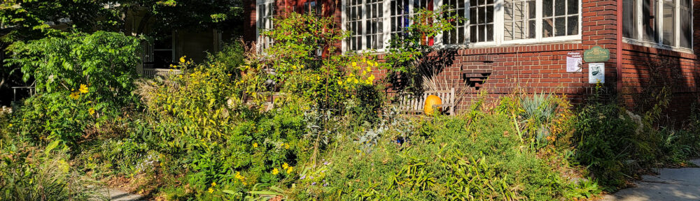
Illustration of Front Yard Planting from DCP’s proposed Yards Text Amendment online presentation
At tonight’s CB14 Public Hearing, this is sure to be one of the items on the agenda. On September 17, NYC’s Department of City Planning (DCP) released a proposal to amend zoning regulations to address, for the first time, the extent of paved and planted areas on private property:
The new regulations would prevent excessive paving of front yards by requiring that a minimum percentage of all front yards be landscaped. They would also prohibit steeply pitched driveways in front yards and encouraging rear yard garages to maximize plantings. Excessively tall fences and steps in front yards would also be prohibited. The zoning would clarify definitions of side and rear yards to provide predictability and ensure that all homes have adequate open spaces. Together with the Department’s initiative requiring the greening of commercial parking lots this package of regulations will enhance the attractiveness of neighborhood streets, mitigate storm water run-off and reduce surrounding temperatures while furthering Mayor Bloomberg’s goals for a greener, greater New York.
– Press Release
The Department of City Planning in proposing amendments to the Zoning Resolution relating to yard regulations for residential developments. Although the current regulations prescribe minimum requirements relating to location and size of yards, they generally do not deal with the amount of paving and planting in the yards [emphasis added]. In addition, the current regulations are in some cases unclear and do not deal with fences and steps.
– Yards Text Amendment, DCP
This will potentially provide huge collective benefits to individual homeowners, neighborhoods, and the city:
- Improved streetscape livability, promoting community and economic sustainability
- Reduced storm drainage and combined sewer outflow
- Improved community health, eg: from reduced asthma rates
- Reduced energy costs, especially for summer cooling and air conditioning
This proposal is a first step toward providing some protections. However, it can only work if the underlying zoning is appropriate. Most of the freestanding homes in what’s known as Victorian Flatbush are zoned R3-2, which permits semi-detached row houses, or R6, which is for 6-story townhouses with a continuous street wall. An R2X designation has been used in other down-zoning initiatives, would appropriately reflect the built environment, and provide even more protections if DCP’s proposed changes are approved.
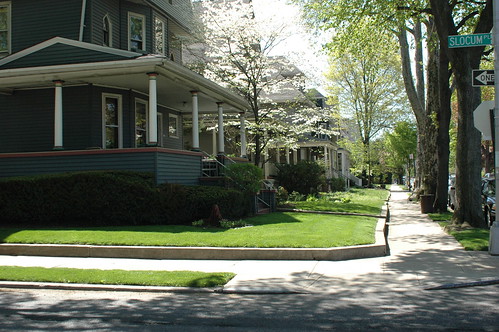
Looking south down Westminster Road in Beverley Square West
Million Trees NYC outlines the economic, tangible, and intangible benefits of NYC’s urban forest:
- Urban trees help offset climate change by capturing atmospheric carbon dioxide in their tissue, reducing energy used by buildings, and reducing carbon dioxide emissions from fossil-fuel based power plants. Our City’s trees store about 1.35 million tons of carbon valued at $24.9 million. In addition, our trees remove over 42,000 tons of carbon each year.
- Urban trees capture rainfall on their leaves and branches and take up water, acting as natural stormwater capture and retention devices. Street trees intercept 890.6 million gallons of stormwater annually, or 1,525 gallons per tree on average. The total value of this benefit to New York City is over $35 million each year.
- Trees remove dust and other pollutants from the air. In fact, one tree can remove 26 pounds of carbon dioxide from the atmosphere annually, the equivalent of 11,000 miles of car emissions. Our trees remove about 2,200 tons of air pollution per year, valued at $10 million annually.
- According to the U.S. Environmental Protection Agency, urban forests reduce urban temperatures significantly by shading buildings and concrete and returning humidity to the air through evaporative cooling.
- By using trees to modify temperatures, the amount of fossil fuels used for cooling and heating by homeowners and businesses is reduced. Our City’s street trees provide $27 million a year in energy savings.
- New York City’s urban forest provides habitat – including food and shelter for many species of birds, insects, and other wildlife, as well as environmental education resources for New Yorkers of all ages.
- Over the years the City has invested millions in its urban forest. Trees provide $5.60 in benefits for every dollar spent on tree planting and care.
- A significant link exists between the value of a property and its proximity to parks, greenbelts, and other green spaces. Smart Money magazine indicated that consumers value a landscaped home up to 11.3 percent higher than its base price. Street trees provide $52 million each year in increased property values.
- The greening of business districts increases community pride and positive perception of an area, drawing customers to the businesses.
- There is growing evidence that trees help reduce air pollutants that can trigger asthma and other respiratory illnesses. Green spaces also encourage physical activity – a healthy habit for any New Yorker.
Looking south down Stratford Road in Beverley Square West
To reach the goal of one million new trees planted in NYC over the next decade, 40% – 400,000 trees – will have to be planted on private property:
The City of New York will plant 60% of trees in parks and other public spaces. The other 40% will come from private organizations, homeowners, and community organizations.
- Street Trees: 220,000
- Parks: 280,000
- Capital Projects and new Zoning Requirements: 100,000
- Private Partners: 400,000
We also need to preserve the existing urban forest, much of which is in private hands, and, with no legal protections, at risk. The proposed zoning amendments would provide much-needed protection in the form of restrictions and incentives.
East side of Rugby Rd, looking north from Church Av, in Caton Park
I had sent this article to myself to write about it when it first appeared. Just getting around to it now. It got caught in a “draft”. (I’m sick today, I have an excuse.)
Lawns, manicured bushes and a riot of flowers have helped distinguish the borough’s streetscape, enhancing the livability of its communities and giving almost a county-in-the-city aura to many blocks.
However, in recent years, that trend has shifted. Front yards in many areas have been paved over, and blooms have been replaced by parking pads, as ever-increasing population density combined with an up-tick in the number of cars per family has made a guaranteed parking spot something of a holy grail, with portions of residential neighborhoods morphing into something akin to a concrete jungle.
[The Department of City Planning (DCP)] has proposed an amendment to the city’s zoning resolution that would require that a certain minimum percentage of all front yards be landscaped, based on the length of the property’s street frontage.
– Parking it here has many people angry, Flatbush Life, October 18, 2007
[goo.gl]
Related Posts
Victorian Flatbush at risk from inappropriate zoning, 2007-10-23
Carolina Silverbell: One of a Million, 2007-10-09
State of Flatbush/Midwood, 2007-10-05
How Much is a Street Tree Worth, 2007-04-09
Landscape and Politics in Brooklyn’s City Council District 40, 2007-02-14
NASA Maps NYC’s Heat Island, 2006-08-01
Links
DCP: Yards Text Amendment Home Page, Press Release, Full text (PDF, 26 pages), Online Slide Show (25 pages, PDF version available)
DCP: Green Initiatives (including the Yards Text Amendment)
DCP Zoning Glossary
Million Trees NYC
November 12: Sustainable Flatbush Town Hall Meeting
This is listed in the sidebar Calendar, but I wanted to highlight this community meeting happening next Monday.
Sustainable Flatbush is about to enter an exciting new phase of our activities in the neighborhood, and we’d love for YOU to be involved! Please join us:
WHAT: Sustainable Flatbush Town Hall Meeting
WHEN: Monday, November 12th at 7pm
WHERE: 462 Marlborough Road (between Ditmas and Dorchester)
Longtime Flatbush resident Mark Levy has come onboard, bringing his history of commitment to the neighborhood and experience as a community organizer and environmental educator. He has also kindly offered to host this meeting at his home. Thanks Mark!
We will form committees geared toward specific activities and service projects, establish leadership roles, and set some new goals for 2008. To give you an idea of what’s in store, here are some of the proposed committees:
• RECYCLING/WASTE REDUCTION
Focusing on recycling education and promotion, as well as other methods of reducing waste in our homes and businesses, from composting to blocking unwanted fliers.
• SUSTAINABLE GARDENING
Sharing knowledge and resources on sustainable approaches to all forms of urban gardening, from yard landscaping to street tree pits to organic farming. We will also be actively involved in the new neighborhood community garden.
• TRANSPORTATION/LIVABLE STREETS
Working with Transportation Alternatives and other Livable Streets advocates, we will bring a local perspective to the citywide discussion of such issues as traffic calming, congestion pricing, public transportation improvements, and infrastructure for pedestrians and cyclists.
• ENERGY EFFICIENCY/ALTERNATIVE ENERGY AND FUELS
Let’s talk about how to save money by using less energy in our homes and businesses, and how to incorporate alternative energy sources such as biofuels and solar power into the landscape.
• LOCAL BUSINESS OUTREACH
Helping neighborhood businesses to adopt sustainability practices that improve their “Triple Bottom Line”: People, Planet, and Profit.
• LOCAL SCHOOLS OUTREACH
Implementing environmental education and practices in our local schools.
Hope to see you there!
Meta: Blog Care & Feeding
I’m home sick today, and it’s cold out, an opportunity to do some blog maintenance, dust off a draft or two, catch up on some of the huge backlog of blog reading.
Links
I’ve been working on re-organizing the sidebar. The newest addition is a section titled “Links > Flatbush & Neighbors.” For the first time, there are enough blogs and other online resources in my area to warrant its own section; four of the blogs listed there are new in the past few months. I don’t want my list for local resources to get lost in the It’s “and neighbors” because I want to recognize the connections, geographical, political, and otherwise, we share.
Blogger recently added a “Link List” widget to their layout tools. It’s pretty basic, but it captures most of what I’ve had since the beginning in the larger, longer “Links” section of the sidebar. It can be kept sorted alphabetically, and I can have multiple sections for each group of links. So I’m gradually migrating from my old, manually-edited raw HTML links to the Blogger widget.
November 7: CB14 Public Hearing on Land Use and Open Space
COMMUNITY BOARD 14 will hold a public hearing on Nov. 7 at 7 p.m. at the district office, 810 E. 16th St (at Avenue H). Zoning issues, tree planting, yards and open space requirements in the area will be discussed. For more information, call (718) 859-6357.
Contact info
Brooklyn Community Board 14
810 East 16th Street
Brooklyn, NY 11230-3010
Phone: 718.859.6357
Fax: 718.421.6077
Email: bklcb14@optonline.net
The OASIS Mapping Service
Welcome, OASIS visitors! In addition to this tutorial, you can see some other examples of OASIS maps elsewhere on this blog:
Flatbush Rezoning Proposal will define the future of Victorian Flatbush, 2008-06-13
Weather Alert: Flood Watch Tonight and Tomorrow, 2008-03-04
Imagine Flatbush 2030, 2007-11-20
The Future Home of the Ex-Lax Gardens, 2007-11-01
In NYC, the non-profit OASIS – New York City Open Accessible Space Information System Cooperative – provides a thematic mapping service on their Web site. I have a link to them in the sidebar of my blog under “Links > NYC”. They consolidate multiple sources of public information. In addition to all the real estate related information, they have layers for groundcover classification, street trees, aerial maps, flood hazards, and so on.
I’ve been using it for the past three and a half years. I’ve used it to generate many of the maps in my blog posts to visualize different themes and issues. I’ve become very comfortable using it.
The Kensington (Brooklyn) blog notes that it “seems to have a ton of info though we can’t seem to figure it out.” They mention a couple of empty lots, including one on Caton Avenue which caught my eye when I passed it on my way to visit their East 4th Street Community Garden this past Saturday. I’ll use that empty lot as an example. What follows is a step by step tutorial on how to use the OASIS Mapping Service to get information about your neighborhood, and get details about a particular piece of property.
1. Select a Theme
An easy way to get started using it is to use the “Search By” drop-down box at the top of the page to select the topic of interest. For this tutorial, select “Neighborhood” for “Search By”, then select “Kensington” for “Neighborhood.” That gets you into the general area. Your map should look like this.
2. Choose your Layers
Note the right-hand column, labeled “New Layers”.
Here you can control what is, and isn’t, displayed on the map. The “Layer” checkboxes on the left control points, lines and borders, and areas. The “Label” checkboxes on the right control text labels, like “Brooklyn” and “Kensington” in the map above.
Let’s get rid of “Brooklyn”; we know that’s where we are! Look for the section labeled “Boundaries & Labels” and uncheck the “County/Borough” box.
Town/Neighborhood
County / Borough
Community Districts
City Council Districts
Let’s see the subway lines and stations, and let’s also see the station names.
Streets
Bridges / Overpasses
zoom in/out Highways / Major RoadsSubway Stations
Subway Routes
Ferry Stops
Ferry Routes
3. Redraw the map
Whenever you change the layers, you need to click the “Redraw Map” button at the top or bottom of the page for your changes to take effect. With our layer changes above, our new map looks like this.
4. Refine your Layers
We said we were interested in vacant lots, so let’s turn on that layer so we can see where they are. It’s the last layer listed in the “Property & Land Use” section. Check the box for that, then redraw.
zoom in/out Block/Lot Boundaries
zoom in/out BuildingsPiers
NYCHA Properties
Schools
Historic Houses
1 & 2 Family Residential
Multi-family Residential
Mixed Use
Commercial
Institutions
Transportation & Parking
Industrial
Vacant Lots
5. Zoom in
Notice that the first two layers in the Property & Land Use section – Block/Lot Boundaries and Buildings – are disabled: they have no check boxes. Instead, there’s a hint: zoom in/out. We can’t view those layers at this scale. We need to zoom in.
Notice the row of buttons across the top of the map.
Identify
Zoom In
Zoom Out
Recenter
Tag map
Help
The “Zoom In” button is enabled. If we click on the map, we zoom into it, centered on the location where we clicked.
Our large vacant lot on Caton is in the upper right of the map, one block east of Ocean Parkway and west of the Parade Grounds. Click on it to zoom in on it. Your map should look something like this, depending on exactly where you clicked.
Now we can see the lot boundaries. We could zoom in closer, but this is a large lot, and it’s big enough for us to select for identification.
6. Identify
At the top of the map, click the Identify button to enable it.
Identify
Zoom In
Zoom Out
Recenter
Tag map
Help
Now, whatever you click on in the map will be identified with detailed information in the area below the map. Click the vacant lot. The map changes to highlight the selected lot with a red border.
Scroll down to the area below the map to see all the details for this property.
Information about the Lot you identified:
Borough: Brooklyn Block: 5321 Lot: 64 Police Precinct: 72 |
Our vacant lot is 701 Caton Avenue. The Block-Lot numbers are 5321-64, information which we can use to get more information, such as the owner of the property, from city databases such as the Department of Buildings.
That’s the basics! You can play around with different layers to produce different thematic maps, zoom in and out, and so on.
Have fun!
Follow-up
There was some additional discussion in the Kensington blog post which sparked me to write this. In particular, comparison was made to PropertyShark, a commercial service that offers similar mapping features with free registration. I’m also registered with PropertyShark. I hardly ever use it.
- I’ve only found a couple of maps that PropertyShark generates that OASIS doesn’t provide. One nice thing that you can get from PropertyShark, but not OASIS, is a map with street addresses overlaid onto it.
- PropertyShark retains Copyright for everything you get through them. They place restrictions on how you can use and reuse the information, even though they’re based on largely the same public information sources as OASIS. Since I’m often posting the maps I create to Flickr and using then on my blog, it’s important to me that the maps be unrestricted.
- PropertyShark requires registration. OASIS does not.