The OASIS Mapping Service

Welcome, OASIS visitors! In addition to this tutorial, you can see some other examples of OASIS maps elsewhere on this blog:

Flatbush Rezoning Proposal will define the future of Victorian Flatbush, 2008-06-13
Weather Alert: Flood Watch Tonight and Tomorrow, 2008-03-04
Imagine Flatbush 2030, 2007-11-20
The Future Home of the Ex-Lax Gardens, 2007-11-01


In NYC, the non-profit OASIS – New York City Open Accessible Space Information System Cooperative – provides a thematic mapping service on their Web site. I have a link to them in the sidebar of my blog under “Links > NYC”. They consolidate multiple sources of public information. In addition to all the real estate related information, they have layers for groundcover classification, street trees, aerial maps, flood hazards, and so on.

I’ve been using it for the past three and a half years. I’ve used it to generate many of the maps in my blog posts to visualize different themes and issues. I’ve become very comfortable using it.

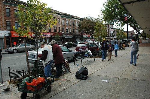
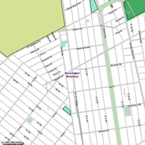
The Kensington (Brooklyn) blog notes that it “seems to have a ton of info though we can’t seem to figure it out.” They mention a couple of empty lots, including one on Caton Avenue which caught my eye when I passed it on my way to visit their East 4th Street Community Garden this past Saturday. I’ll use that empty lot as an example. What follows is a step by step tutorial on how to use the OASIS Mapping Service to get information about your neighborhood, and get details about a particular piece of property.

1. Select a Theme

An easy way to get started using it is to use the “Search By” drop-down box at the top of the page to select the topic of interest. For this tutorial, select “Neighborhood” for “Search By”, then select “Kensington” for “Neighborhood.” That gets you into the general area. Your map should look like this.

Default OASIS Neighborhood Map for Kensington, Brooklyn

2. Choose your Layers

Note the right-hand column, labeled “New Layers”.

New Layers

Here you can control what is, and isn’t, displayed on the map. The “Layer” checkboxes on the left control points, lines and borders, and areas. The “Label” checkboxes on the right control text labels, like “Brooklyn” and “Kensington” in the map above.

Let’s get rid of “Brooklyn”; we know that’s where we are! Look for the section labeled “Boundaries & Labels” and uncheck the “County/Borough” box.

Boundaries & Labels

Legend imageTown/Neighborhood
Legend imageCounty / Borough
Legend imageCommunity Districts
Legend imageCity Council Districts

Let’s see the subway lines and stations, and let’s also see the station names.

Transportation

Legend imageStreets
Legend imageBridges / Overpasses
zoom in/out Highways / Major Roads
Legend imageSubway Stations
Legend imageSubway Routes
Legend imageFerry Stops
Legend imageFerry Routes

3. Redraw the map

Whenever you change the layers, you need to click the “Redraw Map” button at the top or bottom of the page for your changes to take effect. With our layer changes above, our new map looks like this.

OASIS Neighborhood Map for Kensington With Subway Layers

4. Refine your Layers

We said we were interested in vacant lots, so let’s turn on that layer so we can see where they are. It’s the last layer listed in the “Property & Land Use” section. Check the box for that, then redraw.

Property & Land Use

zoom in/out Block/Lot Boundaries
zoom in/out Buildings
Legend imagePiers
Legend imageNYCHA Properties
Legend imageSchools
Legend imageHistoric Houses
Legend image1 & 2 Family Residential
Legend imageMulti-family Residential
Legend imageMixed Use
Legend imageCommercial
Legend imageInstitutions
Legend imageTransportation & Parking
Legend imageIndustrial
Legend imageVacant Lots

OASIS Neighborhood Map for Kensington with Vacant Lots

5. Zoom in

Notice that the first two layers in the Property & Land Use section – Block/Lot Boundaries and Buildings – are disabled: they have no check boxes. Instead, there’s a hint: zoom in/out. We can’t view those layers at this scale. We need to zoom in.

Notice the row of buttons across the top of the map.

Identify Identify Zoom In Zoom In Zoom Out Zoom Out Pan Recenter Tag map Help

The “Zoom In” button is enabled. If we click on the map, we zoom into it, centered on the location where we clicked.

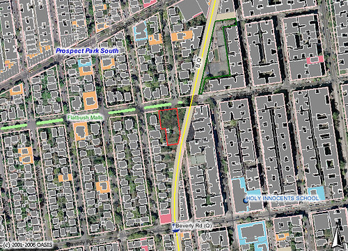
Our large vacant lot on Caton is in the upper right of the map, one block east of Ocean Parkway and west of the Parade Grounds. Click on it to zoom in on it. Your map should look something like this, depending on exactly where you clicked.

Map of Vacant Lot on Caton Avenue in Kensington

Now we can see the lot boundaries. We could zoom in closer, but this is a large lot, and it’s big enough for us to select for identification.

6. Identify

At the top of the map, click the Identify button to enable it.

Identify Identify Zoom In Zoom In Zoom Out Zoom Out Pan Recenter Tag map Help

Now, whatever you click on in the map will be identified with detailed information in the area below the map. Click the vacant lot. The map changes to highlight the selected lot with a red border.

701 Caton Avenue, Kensington, Brooklyn

Scroll down to the area below the map to see all the details for this property.

Information about the Lot you identified:

Borough: Brooklyn Block: 5321 Lot: 64 Police Precinct: 72
Address, ZIP Code: 701 CATON AVENUE, 11218
Lot Area: 29210 sq. feet Lot Frontage: 248.17 feet Lot Depth: 100 feet
Number of buildings: 0 Year built: 0
Number of floors: 0 Building Gross Area: 0 sq. feet
Residential Units: 0 Total # of Units: 0
Landuse: Vacant Land
Zoning: R6: Residential
Commercial Overlay: Zoning Map #: 22C
(PDF version of most recent City Planning zoning map & proposed zoning changes for this area.)
Floor Area Ratio: 0 Max. Allowable Floor Area Ratio: 2.43
(FAR may depend on street widths or other characteristics. Contact City Planning Dept. for latest information.)
Owner: 701 CATON AVE REALTY,
More building information: NYC Dept. of Buildings
More property information: NYC Dept. of Finance Assessment Roll
More zoning information: CITI Zoning Guide

Our vacant lot is 701 Caton Avenue. The Block-Lot numbers are 5321-64, information which we can use to get more information, such as the owner of the property, from city databases such as the Department of Buildings.


That’s the basics! You can play around with different layers to produce different thematic maps, zoom in and out, and so on.

Have fun!


Follow-up

There was some additional discussion in the Kensington blog post which sparked me to write this. In particular, comparison was made to PropertyShark, a commercial service that offers similar mapping features with free registration. I’m also registered with PropertyShark. I hardly ever use it.

  • I’ve only found a couple of maps that PropertyShark generates that OASIS doesn’t provide. One nice thing that you can get from PropertyShark, but not OASIS, is a map with street addresses overlaid onto it.
  • PropertyShark retains Copyright for everything you get through them. They place restrictions on how you can use and reuse the information, even though they’re based on largely the same public information sources as OASIS. Since I’m often posting the maps I create to Flickr and using then on my blog, it’s important to me that the maps be unrestricted.
  • PropertyShark requires registration. OASIS does not.

The Daffodil Project Plantings on Cortelyou Road

Parallel Pit Planting

We had a great turnout this weekend for planting Daffodils along Cortelyou Road. I couldn’t make it yesterday; I heard we had 7 or 8 people. Today we had 13, half of them children.

Yesterday all the new tree pits between Argyle and Rugby Roads were planted. Today we planted nine more: 8 between Marlborough and Rugby, plus the one tree pit between Marlborough and the train station, which has an Oak tree. With 13 people we finished up in a little over two hours.

This is my neighbor, Stacey, one of those who ordered and picked up the bulbs from the Daffodil Project and got this whole thing going.
Stacey

Liena and Hugo

DSC_6020

Group Shot

Thanks to everyone who turned out this weekend, including (in alphabetical order):

  • Ben
  • Cecile
  • Chaakam
  • Emma
  • Faith
  • Hugo
  • Jan
  • Jonathan
  • Kaya
  • Liena
  • Natasha
  • Stacey
  • Tracey
  • Zariya

(If I’ve omitted or misspelled your name, please let me know!)

I’m bad with names, and faces, well, people, basically, but I’m pretty sure I’d never met any of the folks I worked with today. I’ve spoken with some on the phone, or corresponded by email. With most I’d had no previous contact. This is the remarkable community aspect of these kinds of activities. I hope we can do more of them.

Weather permitting, we’ll do it again next Saturday, November 10. We’ll meet at 10am in front of the library at Argyle and Cortelyou. We’ll plant the block from Argyle to Westminster, at least.

The following Sunday, November 11, if we still have bulbs to plant, we’ll schedule it later in the day. There will be another gardening-related community event that morning. I’ll post the details as they’re confirmed.

Links

The Daffodil Project
My Flickr photo set from today

Brooklyn Leaf Collection Dates

This year, leaf collection dates for Brooklyn are Saturday, November 10 (next Saturday) and November 24. You can bag your leaves only in designated paper leaf collection bags. Put them out at the curb Saturday night for Sunday morning pickup.

In fall 2007, it will be mandatory (according to NYC’s Yard Waste Composting Law ) for NYC residents in the city’s leaf collection districts to set out their fall leaves in paper bags (or in unlined rigid containers) during the designated DSNY fall leaf collection period.

How to Set Out Leaves for DSNY Collection:

1. Place leaves into large paper leaf bags. Leaves may also be set out loose in unlined garbage cans. You can be fined for setting out your leaves in plastic bags during DSNY’s leaf collection period.

2. Place leaves at the curb on the designated Saturday evenings.

3. Leaf pickup may take place early the next morning, so place leaves at the curb on the designated Saturday night. Leaves not picked up the next day, will be collected later in the week.

Unfortunately, with the closing of the Spring Creek Composting Site, Brooklyn and
Queens residents are effectively cut off from the spring and fall compost givebacks.

Links

Fall Leaf Collection Program, NYC Department of Sanitation

East 4th Street Community Garden

Updated 2007.11.04: Added Community section.


Afternoon Morning Glory, East 4th Street Community Garden (Windsor Terrace Kensington Veterans Memorial Garden), Kensington, Brooklyn
Afternoon Morning Glory

This afternoon a couple of Flatbush neighbors and I visited the East 4th Street Community Garden. It occupies .184 acres at 179 East 4th Street, between Caton Avenue and Fort Hamilton Parkway in Kensington. It also serves the neighborhood of Windsor Terrace.

The dedicated local residents of the East Fourth Street Garden Association have tended this site, formerly known as the Windsor Terrace Kensington Veterans Memorial Garden, since they first organized it in 1979. The garden, incorporated in 1981, has come to serve a central role as a gathering place in this community. The East Fourth Street garden has funded its operations and special projects through dues collection, flea markets, and two Mollie Parnis Dress Up Your Neighborhood Awards.
Parks Sign, East 4th Street Community Garden

The purpose of our visit was to meet with our gardening neighbors to the west, get ideas from their gardens, and learn from their experience.I arrived around 3pm, before anyone else showed up. That’s when I took most of these photos. I met one of the gardens, Mary Beth, who had brought her pumpkin for composting. We were then joined by two of my neighbors, Gary Jonas and Nelson Ryland. Michael O’Hara, who’s been with the garden for six years, arrived, then Susan Siegel.

Established on city property, the East Fourth Street Garden uses land originally cleared of homes for the construction of the F subway line in the 1930s. Transit builders changed their plans, running the line underground where the Windsor Terrace branch of the Public Library now stands. In 1998, the Department of Housing Preservation and Development (HPD) surrendered the Fourth Street garden between Fort Hamilton Parkway and Caton Avenue to Parks. This arrangement safeguards the garden’s status as a green space while leaving the administration largely in the hands of its community developers.

You can see the grates for the subway in the sidewalk in front of the garden. During our visit, we heard, and felt, the subway rumbling beneath us every few minutes. The future home for the Flatbush Community Garden is adjacent to the open-cut B/Q line; the sounds and sensations of subway trains will be frequent there, as well.

East 4th Street Community Garden

Individual Plots

Here’s a view from the rear of the garden, looking West toward the entrance and East 4th Street. The individual plots are in the center of the photo, extending off-frame to the right. I counted 26 plots.
Individual Plots, East 4th Street Community Garden

Here’s a view from the North, from the shelter of the shady path which is one of the common areas in the garden.
Individual Plots, East 4th Street Community Garden

DSC_5913

The plots are edged with untreated, exterior-grade boards. These are concessions to decorum; as Michael explained, “Plots tend to expand.” Well-defined plot edges, like good fences, make good neighbors. They also keep the plants from spilling into the paths, which need to be mowed regularly, and keep people walking the paths from trampling the plants and plots.

DSC_5915

DSC_5933

DSC_5916

DSC_5917

Plot Signs
Plot Signs

Common Areas

Common areas wrap the garden on its south, west, and north sides. Here are some views of the common areas along the front/street side of the garden.

DSC_5895

DSC_5896

DSC_5882

DSC_5888

One of the features which interested us today was the north side of the garden with several mature trees, including some old apple trees. The Flatbush site, with its forest of 50-year-old trees, has lots of shade. Here a path enjoys the shade from the trees, leading from the front to the rear of the garden, toward the compost area and pond.

View along the shady path

White-Throated Sparrow

Squirrel on old Apple Tree

There Be Woodpeckers

DSC_5900

DSC_5904

Necessaries

I met Mary Beth, one of the gardeners, here by the composting area. She came by to contribute her spent Jack-o-lantern. She lives in an apartment in the area. She told me she “always loved the smell of dirt” growing up. She now has an individual plot in the garden.

Composting area
DSC_5901

I thought the signs were a great way to encourage people to use the compost. They distinguish the finished product from that still in-process, and explicitly grant permission to people to use what they need.
DSC_5902

Also important are clear signs detailing what can and can’t go into the compost.
DSC_5903

Salvaging building materials for reuse in the garden is a way to keep costs down and keep construction and other building debris out of the waste stream.
Salvaged Slate

Salvaged Brick

There’s no free source of water for the garden. Their water bill runs about $400 a year. So collecting and storing rainwater is another sustainability practice that saves the garden money.
Rainwater Collection

Rainwater Diverter

I want to build a bat house. Some of the Flatbush visitors wanted to know “where do you get the bats?” They didn’t know that bats are already native residents of Brooklyn, and “if you build it, they will come.”
Bat House

Bat House

Community

When we visited, the day was overcast and buffeted by winds from tropical storm Noel passing off-shore. We were there after the normal visiting hours, and the garden was empty except for the six of us. Michael told us that we would “have to come here on a busy day in the summer” to see the community in evidence in the garden.

According to Michael, the garden was “a well-kept secret for a long time.” Today there are about 60 people on the mailing list, and 20-30 active members, with a 1 year waiting list. Dues are about $20/year.

Members come from within a four or five block radius of the garden. Maintenance requires weekly visits over the summer, so geographic proximity is important. Members also need to sign up for shifts for shared responsibilities, such as seasonal cleanups and keeping the garden open to the public during scheduled hours. They encourage members who don’t yet have individual plots to plant and maintain containers, or sign-up for the numerous gardening tasks in the common areas. This gives them a feel for the time commitment it takes, especially important for those with little gardening experience.

The garden hosts the Kensington/Windsor Terrace CSA (Community-Supported Agriculture). This CSA is supplied by the Garden of Eve farm on the East End of Long Island. In a recent survey of CSA members, 100% of those responding said they were happy with the garden as a distribution site.

Links

Flickr photo set
East 4th Street Community Garden (OASIS page)
East 4th Street Community Garden (Parks page)
Kensington/Windsor Terrace CSA (Blog)
Garden of Eve
[where: 179 East 4th Street, Brooklyn, NY]

Time to take the umbrella down

The National Weather Service has issued several weather advisories for NYC tomorrow, as Hurricane Noel passes off-shore:

New York City will feel the remnants of Hurricane Noel this weekend, starting late Friday, November 2. High winds will blow into the city and be especially powerful between 6 a.m. and 6 p.m. on Saturday, November 3. During this time, sustained wind speeds will be 30-35 mph, and gusts may reach 45-55 mph.
Wind Advisory

The National Weather Service has also issued a Coastal Flood Advisory and High Surf Advisory for Saturday into Sunday morning.

High winds can cause downed trees and power lines, flying debris and building collapses, which may lead to power outages, transportation disruptions, damage to buildings and vehicles, and serious injury. New Yorkers should secure objects that are outside their homes.

The Future Home of the Ex-Lax Gardens

Updated 2007.11.03: Updated with more history from Erin’s comment. Added photos of the site I took last April.


Future Flatbush Community Garden

This map highlights the future location of a new community garden to be created in Flatbush, in the neighborhood of Prospect Park South. The red border outlines part of the property, which also includes the smaller wedge of land to the east, next to the B/Q subway line. The underlying image is aerial photography from 2004. The gray shapes are the outlines of buildings. The gray box within the red border is a garage, which you can see in the photos below.

The total area is .8 acres, huge by city standards. You can see from the photo that the property is covered by trees. The property is vacant, but not abandoned. It’s owned by a resident of the area who wants it to benefit the community, as a community garden.

Susan Siegel, outgoing Executive Director of Flatbush Development Corporation, has been in communication with the owner of the property for some time. I first heard about this project in February of this year from Jan Rosenberg of Friends of Cortelyou and Brooklyn Hearth Realty. I attended a meeting of some interested community members. Things have been quiet until this week, when Susan let us know that the owner has given us the go-ahead.

The site has an interesting history. As my neighbor, Erin Joslyn, notes, this was originally the home of Dean Alvord, the developer of Prospect Park South, later purchased by Israel Matz:

One of the most impressive homes in Prospect Park South, was the enormous mansion purchased in 1920 by Israel Matz, founder of the Ex-Lax company. After years of neglect, it was consumed by fire in 1958.
Forgotten Flatbush: When Flatbush was Greenwich, Victorian Flatbush, An Architectural history

The forest which lives on the site now is just 50 years old, grown since the building burned down in 1958. “Forgotten Flatbush” includes an old aerial photo of the area from 1908, a hundred years ago, which shows the old “Ex-Lax Mansion”, and the future location of the community garden. The trees for which the neighborhood is known are absent from the photo; they were just a few years old.

Here are some views of the site, taken last April.

Future Site of Flatbush Community Garden
This is the view south down the central drive into the site. The garage is on the right. There’s a lamp post on the left, with Daffodils blooming at its base. Not visible in this photo, the house foundation is to the right.

Future home of the Flatbush Community Garden
This is a view southwest, to the right of the central drive. The garage is to the left. The area in front of the garage and extending to the right is where the house stood.

Old foundation
The sunken area in this photo is part of the original foundation of the house.

Future Site of Flatbush Community Garden
This view is southeast. You can see the garage in this view, too. Somewhere between the garage and where I stood, behind the fence on the right, is the foundation of the house which stood there.

Most community gardens don’t start with a forest. This presents unique opportunities and challenges. The southern end of the property is already partially cleared and cultivated as gardens. For more residents to grow vegetables, more trees will need to be cleared.

I hope that the northern end, at least, can be kept forested. Many of the trees are likely “weed” trees, invasive species, which can and should be removed. There is already wildlife there, and this part of the property could be preserved as a wildlife and bird refuge and sanctuary. There could be wildflower walks and native plant gardens, cool ferny sanctuaries, shady refuges, and story circles.

The foundation of the old house is largely intact, now largely filled in by a half-century of leaf litter and plant growth. This could be cleared and restored. This could become an educational part of the site, evidence of its history. I have visions of developing it as a sunken garden, a grotto of native plants and ferns, which can fulfill other important educational purposes.

Now that the owner has given their go-ahead, there will be many community meetings and other events for those who want to participate and contribute. I’ll post these here on this blog and add them to the calendar in the sidebar.

Links

Backyard of the Day
Forgotten Flatbush
OASIS online mapping service
Ditmas Park Blog
[where: 1522 Albemarle Road, Brooklyn, NY 11226]

Good Place for a Haunting #2

1305 Albemarle Road

This is 1305 Albemarle Road in the landmarked district of Prospect Park South. The ground floor alone has the square footage of our entire house. It’s the largest house in a neighborhood of huge homes. That alone qualifies it as a “monster house.”

But my favorite feature, for this post: check out the windows on the second floor balcony and dormer:

SPIDER WEBS

I’m out of town this week, so I’m “phoning it in”. If I was home, I would get some detail shots of the 2nd floor and dormer windows. Instead, here are a couple of other views. Visit the Flickr photo pages where you can view these images at their largest sizes and see the windows more clearly.

1305 Albemarle Road

1305 Albemarle Road

1305 Albemarle Road

[where: 1305 Albemarle Road, Brooklyn, NY, 11226]

1,000 Daffodils for Cortelyou Road

Two weeks ago I put out a call for volunteers to plant Daffodils along Cortelyou Road, from East 17th Street to Coney Island Avenue. My neighbor Stacey had arranged for 300 bulbs from the Daffodil Project.

Well, she got her order increased to 500 bulbs and received them today. And Friends of Cortelyou and the Cortelyou Road Merchants Association (CORMA) is getting another 500 bulbs for the effort. So we have 1,000 Daffodil bulbs to plant this season which will bloom along the new streetscape of Cortelyou Road next Spring.

The dates for planting are the first two weekends in November, Saturday and Sunday, 11/5 and 11/6, and 11/11 and 11/12. To help us estimate how many hands we’ll have on deck, please fill out the survey in the sidebar, “What date could you help plant bulbs along Cortelyou Road?” To join us, meet at P.S. 139 at the northwest corner of Cortelyou Road and Rugby Road at 10am. You’ll need to bring your own gardening tools for planting: trowels, gloves, gardening forks or spades. But if you don’t have tools of your own, don’t let that stop you; how about bringing some hot chocolate?!

How to plant Daffodil bulbs

Planting Daffodils

When to plant

Keep bulbs cool and dry until you’re ready to plant. You can plant when nights start getting cool. You can plant as long as the ground isn’t frozen. I’ve even planted when the top inch of soil was frozen by frost. I just lifted the top slab of frozen earth, planted my bulbs, then replaced the slab.

Depth

The rule-of-thumb is to plant most bulbs at a depth 3x the height of the bulb. For larger Daffodils, this places the base of the bulb about 6-8 inches down. Smaller varieties, with smaller bulbs, should be planted at a shallower depth.

Spacing

You can space the bulbs about as far apart as the depth you plant them. It depends on the look you want. I like a natural, informal look, so I like to scatter the bulbs gently over the planting area, then plant them where they land.

Plant the bulbs with the nose, the pointy end, facing up, resting on the flat base.
Daffodil bulb

Tips

When planting larger areas, you can dig out the bed to the depth you want to plant, dig in any fertilizer, then place all the bulbs at once before back-filling with the soil you removed.
Daffodil bulbs in place

Daffodils covered

You can plant other, smaller bulbs at a shallower depth over the Daffodil bulbs before completely filling the hole. Bulbs that bloom earlier, such as Crocus (which are corms, not true bulbs, which serve the same function), will extend the Spring bloom season. Anything which blooms later may get smothered or covered by the Daffodil foliage, depending on how densely you’ve planted them.
Crocus corms

Crocus corms scattered above the Daffodil bulbs

Bulbs already have stored most of the food and energy they need to bloom once. To give them a boost, you can dig a little fertilizer into the bottom of each hole before placing the bulb. More important, to keep them blooming and spreading year after year, leave the leaves on the plants after they bloom until they turn brown. It will look messy, but that’s how the bulbs store food for next year’s blooms. Perennials and annuals can be planted alongside the bulbs; their leaves will help cover the dying foliage and keep the area looking neat.