New Flatbush Rezoning Proposal Gets It Right

Update, 2009-07-29: Flatbush Rezoning Proposal approved by City Council


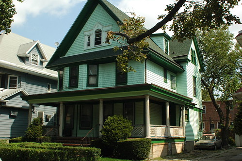
477 Westminster Road, Ditmas Park West, one of hundreds of homes that will receive more protection with DCP’s revised draft
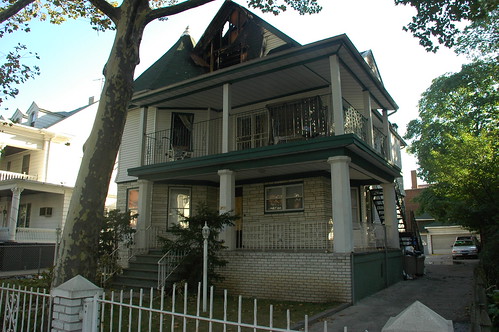
447 Westminster Road, Ditmas Park West

NYC’s Department of City Planning (DCP) provided the first view of their revised draft of the Flatbush Rezoning Proposal to Brooklyn’s Community Board 14 (CB14) on September 3, and more recently to the CB14 Executive Committee on September 18. I wasn’t able to sit in on any of the meetings, but I’ve spoken with folks who’ve seen the new proposal first hand.

The revised draft is covered in Flatbush Life, including a photo of the redrafted map:

After a presentation to the executive committee of Community Board 14 – which greeted the plan warmly – the Department of City Planning (DCP) is moving forward to certify the proposal, which will launch the formal approval process for the rezoning.

During the meeting, which was held in the board office, 810 East 16th Street, DCP received accolades from board members and area residents for reworking the plan to take into account neighborhood concerns.

Flatbush rezoning moving forward

I wrote a detailed report about the earlier draft that DCP presented to CB14 and at a public hearing back in June. From everything I’ve heard and seen about this second draft, they got it right. In general, lots that are 50×100 feet will get the R3X designation, while lots that are 40×100 will get R4A. This is a more tailored approach than the broad brush of R4A that was painted over Ditmas Park West and South Midwood in the first draft. (See my original post for complete details on these zoning designations.)

They really listened to the concerns of residents, went back and re-drafted to address them. The free-standing homes responsible for the physical character of this area of Flatbush will be protected. All of Flatbush will be protected against unlimited height residential development. There are new opportunities for commercial development, and incentives for affordable housing. It’s hard to find something to critique in this draft.

Related Posts

Flatbush Rezoning Proposal will define the future of Victorian Flatbush, 2008-06-13

Links

Flatbush rezoning moving forward, Flatbush Life, 2008-09-28
Rezonings for Flatbush, Canarsie Move Forward, Campaign for Community-Based Planning, 2008-10-06
Flatbush Rezoning Moving Forward, Ditmas Park Blog, 2008-10-07

Flatbush Rezoning Proposal will define the future of Victorian Flatbush

Update, 2009-07-29: Flatbush Rezoning Proposal approved by City Council
Update, 2009-03-02: DCP certified the proposal.


David Parish, DCP, describing the proposed rezoning for South Midwood
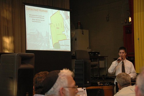
David Parish describing the proposed rezoning for South Midwood

Last night I attended Brooklyn Community Board 14’s (CB14) preliminary public hearing on the NYC Department of City Planning’s (DCP) rezoning proposal for the northern half of CB14, ie: Flatbush. I didn’t take a head count, but roughly 100 people turned out to attend the hearing in Public School 249’s uncooled auditorium. CB14 chair Alvin Berk informally explained the context and ground rules for the meeting, then officially called the hearing to order at 7:23. After the school guard kicked us out – gently, but firmly – after 9:30pm, conversations continued onto the school plaza and sidewalks. I didn’t get home until well after 10pm last night.


Some highlights:

  • One of the four major goals of the proposal is to preserve the existing free-standing single- and two-family homes that characterize the area. On this point, support seemed unanimous, although the terms detached, semi-detached, and attached were new to some in the room and is the cause of some confusion.
  • Not only Ditmas Park West, but South Midwood would be rezoned to R4A. This was the most troublesome part of the proposal at last night’s hearing; nearly all who spoke during the public comments section of the meeting (including me) opposed this particular zoning designation, for reasons explained below.
  • While current zoning puts many of these homes and streets at risk from development, the proposed rezoning may endanger even more.
  • Zoning is a blunt instrument. Currently available zoning designations are insufficient, or at least too coarse, to reflect and respect the existing housing stock in these neighborhoods.

My report will necessarily be incomplete. This was the first time I’ve ever attended a public hearing, so I had only a general idea of what to expect. I had not seen the details of the proposal prior to the meeting. My main purpose in attending the meeting was to learn more details. Unfortunately, there was no opportunity to study the large, detailed exhibits that DCP brought with them. There was only the presentation, and I was writing furiously to try to capture details as they were presented. I also had an opportunity to speak during the public comments section of the meeting. After I spoke, I was out of the room for a few minutes while I (unsuccessfully) sought water. I missed a few speakers during my absence.

The study area

The study area encompasses nearly all of the northern half of CB14. Here’s a detailed map of the study area provided by DCP.

Boundaries of the Study Area
DCP Flatbush Neighborhood Rezoning Study Area

This map of the existing zoning districts was also provided by DCP. To view the map more clearly, follow the link from the map to its Flickr page (just click the image), then select All Sizes > Original.

Existing Zoning
DCP Flatbush Neighborhood Rezoning Existing Zoning

Nearly all of the study area is zoned for residential use. The few commercial-only districts are at the edges. The C4-3 district at the southeast corner of the area is Brooklyn Junction, the intersection of Flatbush and Nostrand Avenues. The largest commercial area is the C4-2 district on the eastern boundary of the study area. This is bounded roughly by Flatbush and Bedford Avenues on the west and east, and Church Avenue and Cortelyou Road on the north and south. Important commercial/retail landmarks in this district include Sears and the Kings Theater.

Loew’s Kings Theater, Flatbush Avenue, just north of Beverly Road
Loew's Kings Theater, Flatbush Avenue

Most of the commercial space is provided as commercial overlays, shown with hatch marks on the map. You can see these along Nostrand and Flatbush Avenues, Church Avenue, Coney Island Avenue, Cortelyou Road, and Newkirk and Foster Avenues. The overlay that spans Newkirk and Foster Avenues at the Newkirk Avenue subway station is Newkirk Plaza.

589-597 Coney Island Avenue
589 (left), 591, 593, 595 and 597 Coney Island Avenue

Cortelyou Road, south side, looking west from Westminster Road

Newkirk Plaza, looking south from Newkirk Avenue toward Foster Avenue. The subway cut is on the right of the photo.
Newkirk Plaza

Within the study area, there’s a wide range of density in residential districts, from R1-2 to R7-1. R1 through R5 are lower-density districts. R6 and R7 are medium-density. There’s also a wide range of housing types.

There are three landmarked historic districts typified by free-standing homes. You can easily locate these on the map by the R1-2 districts. From north to south, they are Prospect Park South, Ditmas Park, and the recently approved Fiske Terrace-Midwood Park. Midwood Park is the southernmost R1-2 area, and Fiske Terrace is the R2 area just south of that. Both R1-2 and R2 allow only single-family detached houses.

Our detached houses are not limited to the landmarked areas. The majority are not landmarked, occupying residential zones ranging from R2 to R6. Those in R6 zones – including those in my neighborhood of Beverley Square West – are at greatest risk.

Summary of the Proposal

The proposal is still only a draft, so all the specifics are still subject to change before the formal proposal, which kicks off the ULURP process. There are four major goals for the rezoning:

  1. Preserve the existing free-standing (detached) single- and two-family houses.
  2. Match new zoning to existing buildings as closely as possible without “under zoning”.
  3. Encourage creation of affordable housing through incentives.
  4. Create opportunities for commercial growth.

In rezoning projects, one of the things DCP looks at is “non-compliance”: does existing development on a site comply with what’s allowed by its zoning designation? Non-compliant and under-zoned describe the same situation: the former applies to the house, the latter to the zoning of the property. Non-compliant does not necessarily mean illegal. The conditions may have pre-dated the zoning; in a neighborhood of homes over 100 years old, they likely do. To understand non-compliance, we need to know the current zoning designation and what it permits.

Case Study: Beverley Square West

Beverley Square West is bounded by Beverly and Cortelyou Roads on the north and south, and the B/Q subway cut and Coney Island Avenue on the east and west. The homes here are detached, single- and two-family homes with peaked roofs, most of which were built in the late 1890s and early 1900s. Most of the lots are 50 feet wide by 100 feet deep.

308 Stratford Road, Beverley Square West
308 Stratford Road

This map shows the outlines of buildings on all properties in the area. The detached homes stand in contrast to row houses along the southern side of Cortelyou Road and the eastern side of Coney Island Avenue.

Single- and Two-Family Homes and existing Structures, Beverley Square West

Most of the area is zoned R3-2, with R6 zoned along the western and southern boundaries.

Existing Zoning, Beverley Square West

Neither R3-2 nor R6 match the existing character of the neighborhood. R3-2 allows not only detached homes but semi-detached homes – side-by-side – as well as fully attached homes, ie: rowhouses. R3-2 specifies a minimum lot width of 40 feet for detached houses, but only 18 feet for semi-detached or attached.

The base floor-to-area ratio (FAR) for R3-2 is .5, or 50%. A typical lot is 50′ wide by 100′ deep, for a total lot area of 5,000 square feet. 50% of that is 2,500 square feet, the maximum permitted floor area for a building with a flat roof. R3-2 also carries an attic allowance, which encourages preservation and development of homes with peaked roofs, of .1, for a total FAR of .6. Since the typical lot area here is 5,000 square feet, 50 x 100, and 60% of that is 3,000 square feet, a house with 3,000 square feet or less is compliant with the .6 FAR. Our house, for example, is 2,750 square feet, as it’s been since it was converted from a single-family to a two-family home in the 1930s, during the Great Depression of that era.

R6 is a medium-density designation and allows for much denser development, typified by this new condo building recently completed at the corner of Stratford and Cortelyou Roads.

1103 Cortelyou Road

The R6 districts are at greatest risk from being torn down for new development. In Ditmas Park West, several homes have already been lost to teardown. To achieve the first goal of the rezoning project, preservation of the existing detached homes, the new zoning must allow only detached houses. Zones which permit only such housing are R3A, R3-X, R4A, and R5A. To preserve the scale of the neighborhoods, the new zoning must come close to the existing FAR of the homes already built. Both R3A and R3-X share the .6 FAR of R3-2. R3-X has the larger minimum lot width, at 35 feet. Of currently available zoning designations, R3-X comes closest to what’s already in place in Beverley Square West. In fact, the current draft of DCP’s zoning study proposes R3-X for both Beverley Square West and East.

Case Study: South Midwood

A house in South Midwood
House in South Midwood

Many of those attending the meeting seemed to be from South Midwood, one of the many neighborhoods that comprise the “Victorian Flatbush” part of Flatbush. The current and proposed zoning for this neighborhood provides a good case study for what’s at stake: the risks to the area from current, inappropriate zoning; the strategies DCP employs when trying to select new zoning most likely to be approved; and the issues with the new designation DCP selected. Also, it’s the only section of the presentation for which I got some usable photographs.

This neighborhood was developed at the turn of the 20th Century, before zoning existed. When the current zoning was established in 1961 (more or less), over 45 years ago, there was little consideration for what was already in place, and whether or not the new zones fit the existing context.

Ditmas Park West and South Midwood, the areas to be rezoned R4A, have a mix of zoning, the majority of which is R3-2. As explained above, R3-2 allows a FAR of .6: .5 base, plus an attic allowance of .1. R4A allows a .9 FAR: .75 base, plus a .15 attic allowance. The R4A FAR of .9 is an increase of 50% over what’s permitted today. It’s this large increase in FAR that raises concerns for residents in these two neighborhoods, who are concerned it will open the door for expansion and enlargement of existing homes, or new development, out-of-scale with the existing homes.

South Midwood, Current Zoning

South Midwood, Proposed Zoning
South Midwood, proposed rezoning

Another house in South Midwood
A house in South Midwood

DCP’s rationale for proposing R4A over R3-X comes back to the issue of under-zoning. They look at the existing buildings to see whether or not they are compliant with the current zoning. When rezoning, they try to assign a new designation in which 75-80% of existing structures would be compliant. This numeric goal arises from practical and political considerations: they want to minimize objections to the rezoning proposal from property owners concerned that their options for expanding or enlarging their homes are being restricted.

However, the situation here is different. By DCP’s calculations, only 51% of existing homes in South Midwood are compliant with the FAR of their current zoning, mostly .6 FAR in the R3-2 district. But the homeowners here are not complaining about lack of expansion options. They are concerned for the future character of their neighborhood caused by an increase in FAR of 50%.

This is one reason why I referred to zoning as a “blunt instrument” at the beginning. There’s no zoning designation which permits only detached houses with a FAR between .6 and .9. To reach their goal of 75-80% compliance – a threshold determined by political efficacy, not a legal mandate – DCP has to leap to the next available FAR of .9 in R4A. But this leap has generated opposition which the threshold was intended to avoid. An intermediate total FAR, of .75 say, which would be an increase of only 25% instead of 50%, would be a better fit and would not receive the same level of opposition. Barring creation of a new zoning designation, residents speaking at Thursday’s meeting called for a new designation of R3X, maintaining the status quo, instead of R4A, which would open up the neighborhood to out-of-scale development.

Related Posts

Flatbush Rezoning Proposal, May 23, 2008
Preserving Livable Streets: DCP’s Yards Text Amendment, November 7, 2007
Victorian Flatbush at risk from inappropriate zoning, October 23, 2007
State of Flatbush/Midwood, October 5, 2007
Landscape and Politics in Brooklyn’s City Council District 40, February 14
NASA Earth Observatory Maps NYC’s Heat Island, Block by Block, August 1, 2006

Important DCP Links

Residence District Zoning Explained
Table comparing R1 through R3 (PDF)
Table comparing R4 through R5 (PDF)
DCP Zoning Glossary

Other Links

South Midwood Residents Association
Brooklyn Community District 14 Profile (PDF)

Times admits past errors: We are not all Ditmas Park

A House in Caton Park
House in Caton Park

I am astonished to find that tomorrow’s New York Times City Section has an article on Victorian Flatbush, not “Ditmas Park,” which they finally realize only applies to one historic district in this large area. And in this article, they focus on the “forgotten” neighborhoods, those which don’t have landmark protection, and which are in danger of being eroded and lost forever to “development”:

The neighborhoods of Victorian Flatbush are of particular interest to historians because in many respects they were the first suburbs. With the newly built Brooklyn Rapid Transit rail line stretching out to Coney Island, the farmland of the Dutch village of Flatbush became a prime location in the early 20th century for what was considered commuter living.
Peaked Roofs, Crossed Fingers

315 East 18th Street, Beverly Square East

All the neighborhoods featured houses built in the most fashionable of Victorian-era styles, among them Tudor, Queen Anne, Colonial Revival and Georgian. These houses, adorned with carved moldings, fluted columns, copper trimmings and wide, open porches, evoked a lifestyle that went beyond architecture. Exclusive social clubs flourished in the area, as did community associations, many of which have been the driving force in campaigns for historic protection.

457 Rugby Road, Ditmas Park West
457 Rugby Road

House in South Midwood

“We don’t want the Manhattanization of Brooklyn,” said Ron Schweiger, the Brooklyn borough historian and a longtime resident of Beverley Square West. “We don’t want high-rises coming into residential areas. That’s why we want all of Victorian Flatbush to get historic district status.”

And though the neighborhoods of Victorian Flatbush have distinct characters, nearly all of them have one thing in common: residents eager to protect what is a remarkable and in some cases irreplaceable architectural history.

Beverley Square West

341 Rugby Road, Beverley Square West

209 (Left) & 215 (Right) Stratford Road, Beverley Square West
209 (Left) & 215 (Right) Stratford Road

There’s a little bit of hand-waving around my neighborhood of Beverley Square West, resulting in several inaccuracies.

Beverley Square East and West, nestled between Prospect Park South and Ditmas Park [and Ditmas Park West] and completed just after the turn of the 20th century, were Ackerson’s major projects. The developer also got certain streets that run through Beverley Square West rechristened with upper-crust British names: East 12th, 13th, 14th and 15th Streets became Westminster, Argyle, Rugby and Marlborough Roads.

Somehow the Times lost one-fifth of Beverley Square West, omitting Stratford Road (East 11th Street) from their description of the neighborhood. Stratford Road is both the westernmost block and the one most at risk from inappropriate zoning in Beverley Square West and Ditmas Park West.

The street names originated in the development of Prospect Park South by Dean Alvord. Ackerson’s early advertising for developments here still used the numbered designations of East 11th, 12th, and so forth, not the names. By 1902, the named designations were extended south to what would become Beverley Square West and Ditmas Park West. Our bill from Con Ed, which was around before this building boom of the early 1900s, still uses the numbered designation for our street address.

All the original homes of the Beverley Squares were individually designed. Ackerson himself lived in a house in Beverley Square West, and the developer Pounds, a future borough president, lived in Beverley Square East.

From what I’ve learned of the history of the development here, this is not accurate. The houses on Stratford and Westminster Roads are stylistically different from those on Argyle, Rugby and Marlborough. Although no two houses are exactly alike on Stratford and Westminster, neither do they feature much of the architectural details – turrets, round oeil de boeuf (ox-eye) windows, unusual dormers, and so on – visible on nearly every house on the other blocks.

I think the houses on these two westernmost blocks were built largely using Victorian pattern books widely available at the time; they were mostly “builders’ specials,” not designed by architects. They were built earlier, and not by Ackerson. Early Ackerson promotional photos show houses already standing on Stratford and Westminster while Argyle and Rugby are nothing more than empty lots.

The earliest neighborhood name I’ve found for these five blocks is Matthews Park. Matthews Court is one of the short side streets joining Stratford Road and Coney Island Avenue. Not that long ago, “Beverley Square West” referred only to the Ackerson-developed blocks of Argyle, Rugby and Marlborough Roads. Stratford and Westminster had their own neighborhood association, called Westford Park. These two neighborhood associations joined forces to form the current, five-block Beverley Square West Association.

Street Sign, Matthews Court

Related Posts

Victorian Flatbush at risk from inappropriate zoning, October 23, 2007
Landscape and Politics in Brooklyn’s City Council District 40, February 14, 2007
Matthews Park, September 29, 2006

Links

NoProPaSo, Kneel Before Your Creator, Crazy Stable
Victorian Flatbush: An Architectural History (Warning: contains intrusive popups)

The Luminous Streets

P.S. 139, Cortelyou and Rugby Roads, Beverley Square West, Flatbush, Brooklyn
P.S. 139, Beverley Square West, Brooklyn

This has been a spectacular year for fall foliage. We had ample, sometimes record, rainfall over the summer. We didn’t get a long drought at the end of the summer which often ruins the fall colors. And temperatures finally got cool at night, while warm during the day. We just had our first hard freeze this week.

Barbara Corcoran, avert your eyes. The rest of us can enjoy this gift. We’re just past peak this weekend, but there’s still plenty of great color. So get out and walk around.

Fothergilla, Vinca minor, and Maple leaves, 329 Westminster Road, Beverley Square West
329 Westminster Road

Japanese Maple, 1505 Albemarle Road, Prospect Park South

Field 11, Parade Grounds, Caton Avenue

Abandoned, East 16th Street

315 East 18th Street, Beverly Square East

346 East 18th Street, Beverly Square East
346 East 18th Street, Beverly Square East, Brooklyn

196 Marlborough Road, Prospect Park South

Beverly Road, Beverley Square West
Beverly Road, Beverley Square West, Flatbush, Brooklyn

Japanese Maple in front yard, 260 Westminster Road, Beverley Square West
Japanese Maple in front yard, 260 Westminster Road

I’ve been walking past, beneath, this every morning on my way to the Beverly Road subway station. Nothing like starting your commute in awe.

1422 Beverly Road, Beverley Square West
1422 Beverly Road

Sunday: Bonus Daffodil Planting on Beverly Road

Sunday morning there will be additional Daffodil planting along Beverly Road. I’ve been in correspondence with a neighbor, Natasha, from Beverly Square East. She wrote me earlier today:

This is just a quick note to let you know that I’m planning to plant Daffodils on Sunday 11/11 starting at 10am. I’ll be meeting some friends on Beverley between 16th and 17th street. We’re going to start at 16th Street and head towards Flatbush. I borrowed some extra planting implements from a friend, so people should feel free to come even if they don’t have tools.

So Sunday you have two opportunities for planting Daffodil bulbs. Meet at 10am on Beverly Road between 16th and 17th Street; planting will proceed east along Beverly Road. Or meet at 10am at the library plaza on Cortelyou Road at Argyle; planting will proceed west toward Coney Island Avenue.

1,000 Daffodils for Cortelyou Road

Two weeks ago I put out a call for volunteers to plant Daffodils along Cortelyou Road, from East 17th Street to Coney Island Avenue. My neighbor Stacey had arranged for 300 bulbs from the Daffodil Project.

Well, she got her order increased to 500 bulbs and received them today. And Friends of Cortelyou and the Cortelyou Road Merchants Association (CORMA) is getting another 500 bulbs for the effort. So we have 1,000 Daffodil bulbs to plant this season which will bloom along the new streetscape of Cortelyou Road next Spring.

The dates for planting are the first two weekends in November, Saturday and Sunday, 11/5 and 11/6, and 11/11 and 11/12. To help us estimate how many hands we’ll have on deck, please fill out the survey in the sidebar, “What date could you help plant bulbs along Cortelyou Road?” To join us, meet at P.S. 139 at the northwest corner of Cortelyou Road and Rugby Road at 10am. You’ll need to bring your own gardening tools for planting: trowels, gloves, gardening forks or spades. But if you don’t have tools of your own, don’t let that stop you; how about bringing some hot chocolate?!

Illegal Conversions Kill

Update, September 25: This morning’s news reports have additional information about the living situation in the building.


251 East 19th Street, the morning of September 25
251 East 19th Street

Shortly after midnight this morning (September 24), a fire broke out in a house several blocks from mine, in the adjacent neighborhood of Beverly Square East, one of the neighborhoods of free-standing, wood-frame Victorian homes in the larger area known as Victorian Flatbush. Early reports misidentified the neighborhood as Kensington. Some reports are still misidentifying the neighborhood as Ditmas Park, which is a historic district whose northern boundary lies two blocks to the south.

The immediate cause of the fire was an electric malfunction. The deeper cause is the illegal conversion of a single-family home to multiple units. The property is on file as a single residential unit, a single-family home. There were as many as 6 people living on the attic floor where the fire broke out; three of them, aged 76, 50 and 12, were killed by this fire, and one remains in serious condition. The only working smoke detector was on the first floor.

At least one report cites “numerous violations” against the owner of the building. However, most of the violations and complaints I can find are all several years old, and were all “cured” or “resolved”. There is one active complaint, created today, for failure to maintain a fire-damaged building.

I learned from news reports the morning of the 25th that this was not an absentee landlord situation. The 11 people who lived on the top two floors of the building, including the three killed, are part of the owner’s extended family. Three more people live on the first floor.

The existing system of DOB violations is broken. Fines and liens are insufficient deterrents. DOB and FDNY must have the authority to obtain warrants to enter buildings to investigate outstanding safety and occupancy violations. Owners’ income from such buildings must be seized, paid into escrow, until the DOB and FDNY certify that life-threatening conditions have been resolved.

Links:

Hero boy dies trying to save 2 from fire (NY Daily News, September 25)
Boy, 12, dies in fire trying to save grandmother (Newsday, September 25)
Fire Kills 3, From 3 Generations, in a Crowded House in Brooklyn (New York Times, September 25)
Man Rescues Teenager From Blazing Brooklyn Rooftop (New York Sun, September 25)
Deadly fire rips through a home in Brooklyn (7Online, ABC local affiliate)
FDNY Says Electrical Wiring To Blame For Deadly Brooklyn Fire (NY1 News)
Google News