TODAY: Imagine Flatbush 2030 on the Brian Lehrer Show

UPDATE: The podcast is available from WNYC’s Web site, or through the widget below.


I just learned of this a few minutes ago. Today on the Brian Lehrer Show:

Susan Siegel, outgoing executive director of the Flatbush Development Corporation (FDC)and Zenobia McNally, local resident and business owner and Eve Baron, director of The Municipal Art Society Planning Center and the project manager for Imagine Flatbush 2030, discuss their efforts to create a community-directed development plan for Brooklyn’s Flatbush neighborhood.

The Brian Lehrer Show airs weekdays at 10AM on 93.9 FM and AM 820 and Tuesdays through Saturdays at 1AM on AM 820. The call-in number is 212-433-9692 (or 212 433 WNYC).

Related Posts

The Albemarle Road Pedestrian Bridge, November 25
Imagine Flatbush 2030, November 20

Links

Making Jane Jacobs Proud in Flatbush, The Brian Lehrer Show
Imagine Flatbush 2030, Municipal Art Society

Where is Flatbush, Anyway?

Update 2007.11.04: For others’ reactions to the Times piece, see the Links at the end of this post, or check out the list on Brooklyn Junction. Also added a link to a 1998 letter to the editor about their invention of “Greater Ditmas Park.”


Map of Flatbush in 1873
Map of Flatbush, 1873


Today, the “Living In” feature of the Real Estate section of the New York Times looks at Flatbush:

More than a neighborhood, Flatbush often refers to a sprawling community in central Brooklyn comprising multiple smaller ones.
… But many smaller neighborhoods traditionally under the Flatbush umbrella, including Ditmas Park and Prospect Park South, have asserted distinct identities. So, the character of what might be called Flatbush proper — a rectangle anchored at the south by Brooklyn College — has come into sharper focus.
Note to City Dwellers: Steals Available Here

The article claims “the borders of Flatbush are ambiguous”:

Neighborhoods once considered part of it have reclaimed their more specific names. Today, its western border is generally considered Ocean Avenue, beyond which are the various parts of Victorian Flatbush. Its eastern border is New York Avenue, beyond which is East Flatbush. The northern boundary is Parkside Avenue; on the south it is the Long Island Rail Road tracks, just above Avenue I.

This is not the first time the Times has gotten confused about the boundaries of the area. In 1998, they invented the term “Greater Ditmas Park” to cover several other neighborhoods, and a West Midwood resident took them to task for it:

Ditmas Park, along with Prospect Park South, Beverley Square West, West Midwood, South Midwood, Fiske Terrace, and the other neighborhoods in the area discussed are not part of ”Greater Ditmas Park” but of Flatbush.

Maybe that’s where Corcoran picked up their bad habits.

Part of the ambiguity is that the name “Flatbush” is used at two different scales, at least. There was the old Village, then town, of Flatbush, located along what was a trading trail and became the Flatbush Avenue of today. There was also the Township of Flatbush prior to consolidation, with Brooklyn in 1894, then with New York City in 1898. The township included the farmlands to the west of the town of Flatbush. These were developed at the turn of the last century into the “many smaller neighborhoods” the Times mentions.

The Township of Flatbush also extended north of the Times designation, bordering the Township of Brooklyn. In the Brooklyn Botanic Garden, a few hundred feet in from its southwestern entrance near the Carousel in Prospect Park, is a brass line and plaque marking this boundary:

Brooklyn-Flatbush Boundary Marker

Brooklyn-Flatbush Boundary Marker

Brooklyn-Flatbush Boundary Marker

The only substantial community garden in the area also gets a mention:

In 2002, the couple bought a one-bedroom co-op on Glenwood Road with an eat-in kitchen and spacious foyer … They started meeting neighbors through a residents’ association and the Campus Road garden, a community garden at Brooklyn College. In addition to the pleasure of tending their 10-by-13-foot plot, they enjoy summer social gatherings in the garden.

Related Posts

Forgotten Flatbush: The Albemarle Road Pedestrian Bridge

Links

Across the Park
Brooklyn Junction
Ditmas Park Blog
Fading Ad Blog
Hawthorne Street

Summary of the Kickoff Meeting of the Gardening Committee of Sustainable Flatbush

Updated 2007.11.30: Added the complete list of ideas which came out of the brainstorming session.


Last night I hosted the kickoff meeting for the Gardening Committee of Sustainable Flatbush. Clockwise from lower left in the photo are Mela, Anne, Lashonda, and Bruni.
Sustainable Flatbush Gardening Committee Kickoff Meeting

At the end of the evening, I asked if someone was willing to co-chair, and Bruni volunteered. She will report to the general meeting next Monday. What follows is my summary of how the evening went.


We opened with some quick introductions, everyone helped themselves to tea and cookies, then we settled in for a quick brainstorming session. As you can see in the photo above, my little card table wasn’t big enough to hold all the ideas we generated in just a few minutes. Next time I’ll use a bigger table.

Next we reviewed everything each of us had written while grouping and clustering the cards. For example, we had clusters for ideas related to composting, schools and youth, gardening techniques, street trees, and community. This sparked more discussion, questions and answers, and more ideas.

The strongest theme to come out of the meeting was “community.” Each of us feels strongly about the connections between community and gardening. I talked about my experiences with the Daffodil planting on Cortelyou Road. Bruni talked about her experiences with a community garden, and the community of gardeners, in the East Village. Others talked about their desires to organize people in their buildings, and on their blocks.

We decided to focus on a single near-term action: a public community meeting in late February. The idea is to get people excited about the possibility of doing something with their building, their block, their neighbors in 2008, and connect them with opportunities to learn more and organize. I’ve contacted BBG’s Brooklyn Greenbridge to see if they can do a Flatbush-oriented version of their “Greening Up Your Street” program. Even if not, we’ll be able to put some kind of program together.

We don’t have a date yet for our next meeting. We’re thinking it might be sometime in January. When we have a date, it’ll be announced here and on the Sustainable Flatbush motherblog.

I’m inspired by this definition of community gardening:

What is a Community Garden?
Any piece of land gardened by a group of people.
American Community Gardening Association

By this definition, we can create “Community Gardens” everywhere:

  • Tree pits
  • Median strips
  • Planter boxes
  • Grounds and foundation planting areas of apartment/coop/condo
    buildings

Imagine turning our streets into community gardens …

I’ll close with this photo. This shows the state of our table workspace after we had done the grouping and clustering. Visit the Flickr photo pages for this and the opening photo; they have notes with the text from some of the cards. This photo also shows that my home-made, from scratch, double Callebaut bittersweet chocolate chip cookies were well-received.
Sustainable Flatbush Gardening Committee Kickoff Meeting

The crayons were popular. I also ended up with some nice drawings and doodles on the paper covering the card table. I’ll have to get some photographs of those as well.

Ideas

Here’s the complete list of ideas, in alphabetical order, which came out of our brainstorming session.

Adopt a tree
Apartment building gardens/landscaping
Aromatic gardening
Assisting renters in taking/using green space in or around buildings
BBG/Brooklyn Greenbridge
Benches around tree pits (wood benches)
Brooklyn College Garden
Buddy gardening
Build community
City repair (Portland model)
Community composting
Community garden
Compost
Demonstration gardens
Donate food grown to families with food challenges
Educate neighbors about types of trees in neighborhood
Engage youth/children
Find neighbors with farming experience
Food, not lawns
Gardens/farms in schools
Green roofs
Ground cover for older tree pits
Grow food
Guerilla gardening
Highlight/profile local gardeners
Kids education (PS 139, PS 217, and at other local schools)
Lawn care practices
Library Plaza Garden
Million Trees NYC
Planting in Newkirk Plaza
Public composting
Rain barrels
Rain gardens
Red Hood Community Farm
School compost
Sponsor a tree
Street arboretum
Tree signs
Vermi-composting
Window boxes
Xeri-scaping

Good Place for a Haunting Landmarked

2274 Church Avenue, Flatbush, Brooklyn
2274 Church Avenue

Remember me? I’m now a landmark:

A former public school in Flatbush has been approved for designation as an individual landmark by the Landmarks Preservation Commission. At its meeting on Tuesday, Nov. 20, the commission voted 8-0-0 to approve a recommendation by its research department to designate the former Flatbush District No. 1 School, later named PS 90, at the corner of Church and Bedford avenues and adjacent to Erasmus Hall High School.
Landmarks Commission Designates Former PS 90 in Flatbush, Linda Collins, Brooklyn Eagle, 11/26/2007

Given the condition it’s in, I hope this action hasn’t come too late to save this building. I bet this would make a terrific community center in an area that’s sorely lacking public meeting space.

Related Posts

Good Place for a Haunting, October 27

Links

[where: 2274 Church Avenue, Brooklyn, NY]

Forgotten Flatbush: The Albemarle Road Pedestrian Bridge

In the first Imagine Flatbush 2030 workshop, we enumerated “Assets” and “Challenges”. At our table – and it sounded like the experience was shared at others’ – where someone lived emerged as a primary determinant of what appeared in which category. Sometimes shared concerns, such as transportation, appeared as both an asset and a challenge, depending on where one lived. It became clear to me that the lines can be sharply drawn, sometimes block-by-block.

I’m a newcomer to the area, having moved here only in Spring of 2005. I researched more and more about the area and its history as we committed to buying a home and moving here. I’ve still only visited a small portion of Flatbush. IF2030 is making me curious about exploring more of it.

Part of what I want to explore more of is literally “on the other side of the tracks” from where I make my home. The B/Q subway line runs through this neighborhood as an open trench. There are several places where there is no crossing, and the cut forms a geographical barrier, a steel river, separating one side from the other. It wasn’t always so. With homage to Forgotten NY, here’s a little piece of Flatbush that’s not quite forgotten, still part of living memory, the Albemarle Road pedestrian bridge.

Google Map of the location of the old Albemarle Road pedestrian bridge. 143 Buckingham Road is also highlighted; it’s a landmark in all the historical photos of this crossing. The markers show where I took the photos for this article.

View Larger Map

The BMT as I remember — never rode it much, but had relatives on East 17th & Beverley Road. We would always go to the Albemarle Road footbridge by the tennis courts over the BMT cut, and watch the trains.
– Steve Hoskins, SubTalk Post #93389, NYC Subway

Eastern Dead End of Albemarle Road at Buckingham Road. 143 Buckingham Road is at the left of the photograph.
Dead End, Albemarle Road at Buckingham Road

Western foundation of Albemarle Road Pedestrian Bridge

“I seem to have a memory – or is it just a dream? – going back to my earliest childhood, associated with a place about a mile in a different direction from where I lived, towards Prospect Park: it is a stretch of about five blocks of Albemarle Road, going from the Brighton subway underpass to Coney Island Avenue. One got there from our side of the subway tracks by crossing over on a small footbridge. On the far end of the bridge, Albemarle Road suddenly widens, and in the middle of it there is a traffic island, covered with trees and extending a 11 the way to Coney Island Avenue; there are also trees on both sides of the street. My first encounters with this scene are in my memory entirely intermingled with my dreams of it, a recurring vision of overwhelming loveliness at the edge of things, beyond which something entirely new and different must lie.”
– Ronald Sanders, A Brooklyn Memoir, via Living in Victorian Flatbush

Western Dead End of Albemarle Road near East 17th Street. 143 Buckingham Road is at the right of the photograph, across the tracks.
Western Dead End, Albemarle Road, near East 17th Street

East Foundation of Albemarle Road Pedestrian Bridge. 143 Buckingham Road is in the center, across the tracks.
East Foundation of Albemarle Road Pedestrian Bridge

Albemarle Road is interrupted by the subway cut for the B/Q lines. In the late 19th Century, several rail lines were developed to take passengers from the City of Brooklyn, what we now think of as downtown Brooklyn, through the other villages and towns such as Flatbush, to the beach resorts on Coney Island and Brighton Beach. By the 1870s the Brooklyn Coney Island Railroad ran along Coney Island Avenue. By the 1890s, the Brooklyn, Flatbush and Coney Island Railroad (BF&CI) ran along what is now the current route of the B/Q subway line. Most of Flatbush was still farmland at the time. When the Flatbush farms were sold and the area was developed at the turn of the 20th Century, the tracks still ran at grade.

In this 1873 map of Flatbush, Prospect Park and the Parade Grounds are already laid out to the north, and the Brooklyn Coney Island Railroad runs along Coney Island Avenue. On this map, Parkside Avenue is named Franklin Avenue, Church Avenue is named Church Lane, and Cortelyou Road is named Turner Harrow (or Narrow?) Lane. The Waverly Avenue shown on this map no longer exists; it’s later replaced by Albemarle and Beverly Roads Road, whose future locations are shown, but neither named nor yet built. The future route of the B/Q line is not shown. The families whose landholdings and houses appear on this map lent their names to several streets and neighborhoods: Turner, Hinkley, Ditmas and Vanderveer.
Map of Flatbush, Brooklyn, 1873

In an 1888 USGS Survey Map of Brooklyn, just a small portion of which is shown here, Waverly Avenue has been “de-mapped.” The roads built in its place, unnamed on this map, are Avenues B and C; these will be renamed later to Beverly and Cortelyou Roads. Between them run East 11th through East 14th Streets; in the early 1900s, these will be renamed to Stratford, Westminster, Argyle and Rugby Roads to cash in on the cachet of Prospect Park South. The BF&CI, which began service in July 1878, is also now in place. East of that, the eastern half of Avenue A (Albemarle Road) has been built, along with East 17th through 19th Streets.
Detail, 1888 USGS Survey Map of Brooklyn

Through the early 1900s, all these railroad lines ran at grade, at street level. There were also trolley lines, at first horse-drawn, then later electrified, on many of the crossing streets. Development brought a burgeoning residential population, more traffic, and more traffic conflicts and accidents. The decision was made to separate the rail and street traffic by moving them to different levels, passing above and below each other.

This photo from the 1918 “Reports of the Brooklyn Grade Crossing Elimination Commission” shows the Albemarle Road Footbridge. The line has been widened to four tracks and now runs below grade. Today, the local Q train runs on the outer tracks, while the express B runs on the inner tracks. 143 Buckingham Road is visible on the upper left of the photograph. Thanks to Art Huneke for permission to use this photograph. This photo appears on his page Brighton Beach Line, Part 3.
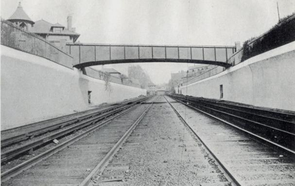
Albemarle Road Footbridge

The physical contrasts could hardly be stronger across the tracks: a wide, tree-lined boulevard with large, detached wood-frame houses on one side, and tall, multiple-unit residential buildings with few trees on the other. It is tempting to imagine what it would be like to restore the pedestrian bridge, eliminating at least a geographical barrier between these two halves of the same neighborhood. Would it help us to make other connections, to recognize our common assets and challenges, and work together to create a future we can all live with?

Related posts

Imagine Flatbush 2030

Links

My Flickr photo set
Brighton Line, NYC Subway
ARRT’s Archives, Art Huneke’s Web site
Rapid Transit Net
The Brooklyn Grade Crossing Elimination Project, 1903-1918

The Luminous Streets

P.S. 139, Cortelyou and Rugby Roads, Beverley Square West, Flatbush, Brooklyn
P.S. 139, Beverley Square West, Brooklyn

This has been a spectacular year for fall foliage. We had ample, sometimes record, rainfall over the summer. We didn’t get a long drought at the end of the summer which often ruins the fall colors. And temperatures finally got cool at night, while warm during the day. We just had our first hard freeze this week.

Barbara Corcoran, avert your eyes. The rest of us can enjoy this gift. We’re just past peak this weekend, but there’s still plenty of great color. So get out and walk around.

Fothergilla, Vinca minor, and Maple leaves, 329 Westminster Road, Beverley Square West
329 Westminster Road

Japanese Maple, 1505 Albemarle Road, Prospect Park South

Field 11, Parade Grounds, Caton Avenue

Abandoned, East 16th Street

315 East 18th Street, Beverly Square East

346 East 18th Street, Beverly Square East
346 East 18th Street, Beverly Square East, Brooklyn

196 Marlborough Road, Prospect Park South

Beverly Road, Beverley Square West
Beverly Road, Beverley Square West, Flatbush, Brooklyn

Japanese Maple in front yard, 260 Westminster Road, Beverley Square West
Japanese Maple in front yard, 260 Westminster Road

I’ve been walking past, beneath, this every morning on my way to the Beverly Road subway station. Nothing like starting your commute in awe.

1422 Beverly Road, Beverley Square West
1422 Beverly Road

Monday 11/26: Kickoff Meeting for the Gardening Committee of Sustainable Flatbush

At last week’s Sustainable Flatbush Town Hall Meeting, six committees were established to focus on different areas:

  • R3 (Reduce, Reuse, Recycle)
  • Livable Streets
  • Energy Efficiency
  • Businesses
  • Schools
  • Gardening

Next Monday, November 26, at 7pm, the Gardening Committee will have a kickoff meeting.

There are three main items on the agenda:

  • Brainstorm ideas about what the committee can do. Sustainable Flatbush’s mission is to educate, advocate, and act on issues of sustainability in our area. What are our ideas for how gardening relates to that mission?
  • Identify a couple of things we can do immediately, especially over the winter
  • Identify co-chairs for the committee who will coordinate with the other committees and larger organization and recruit and support committee members.

If you want to attend next Monday’s meeting please email me at [xrisfg at gmail dot com]. I’ve setup a Google group for committee planning. If you can’t attend next Monday but want to help with gardening committee planning, let me know as well.

Imagine Flatbush 2030

Update 2007.12.13: Added link for all related posts on Imagine Flatbush 2030.


Imagine Flatbush 2030 Winning Logo, Credit: Imani Aegedoy, 11-9-2007

Last night I attended the first of a series of four workshops for Imagine Flatbush 2030. Brooklyn Junction and
Sustainable Flatbush were also in attendance. Sponsored by the Municipal Arts Society (MAS) and Flatbush Development Corporation (FDC), IF2030 is a community-based process to develop goals and indicators to inform any future planning for the area:

The Mayor’s PlaNYC2030 is a citywide sustainability agenda that lays the groundwork for achieving and maintaining affordable housing, open space, good transportation, clean air, water, and land and reliable energy. It affords an enormous opportunity to rethink the development of the city. As part of Jane Jacobs and the Future of New York, MAS will work with the residents, business owners, and civic leaders of Flatbush, Brooklyn, with the partnership of the Flatbush Development Corporation, to assist in creating neighborhood sustainability goals and tools to measure progress toward consensus-based goals.
Imagine Your Neighborhood 2030: a Community Visioning Project

The project study area [PDF] comprises the northern half of Brooklyn’s Community District 14, north of the old LIRR right-of-way which runs between Avenues H and I.
Northern Half of Brooklyn's Community District 14

There will be three more meetings, one each in December, January and February. The final report will be published in March 2008. The next meeting will be Wednesday, December 12, likely to be hosted at Brooklyn College. If you live or work within the study area and would like to get involved, contact Sideya Sherman of MAS [ssherman at mas dot org] or Aga Trojniak of FDC [trojniak at fdconline dot org].

Flatbush is one of the most culturally and ethnically diverse neighborhoods in the city, growing at a rate of eight percent annually, and mirroring the needs and attributes of a growing population within a district that is both architecturally and historically distinct. Yet the lack of affordable housing undermines the ability of the neighborhood to stay diverse, the resident to open space ratio is among the highest in the city, and heavy vehicular traffic compromise the quality of life.

This area is one of great diversity: ethnic, cultural, religious, and other. It is also an area of great disparity in economics, services, and environmental amenities.

“Welcome” in eleven languages on street sign for Newkirk Family Health Center, 1401 Newkirk Avenue
Newkirk Family Health Center, 1401 Newkirk Avenue

Kings Theater, Flatbush Avenue

GreenBranches, Flatbush Branch, Brooklyn Public Library

Da Pride a Flatbush, FDNY Engine 281
Da Pride a Flatbush

Greenmarket, Cortelyou Road

Flatbush-Tompkins Congregational Church, Ditmas Park
Flatbush-Tompkins Congregational Church

599 Coney Island Avenue

2274 Church Avenue
2274 Church Avenue

Christ My Sufficiency, Brooklyn Foursquare Church, 603 Rugby Road

Townhouses in Caton Park

Flatbush E-Cycling, Cortelyou Road
Flatbush E-Cycling

Together We Can Change the World

Susan Siegel of FDC opened the meeting and introduced the MAS team. Conducting the meeting on behalf of MAS were:

  • Eve Barron
  • Sideya Sherman
  • Lacey Tauber
  • Elizabeth Yeampierre (Executive Director, UPROSE)
  • Juan-Camillo Osario

The IF2030 Advisory Committee includes:

  • State Senator Kevin Parker
  • State Assembly Member Rhoda Jacobs
  • State Assembly Member Jim Brennan
  • Brooklyn Borough President Marty Markowitz
  • City Council Member Mathieu Eugene
  • Ms. Anne Pope (Sustainable Flatbush)
  • Ms. Gretchen Maneval (Center for the Study of Brooklyn, Brooklyn College)

Contact

Imagine Flatbush 2030 c/o
Municipal Art Society
457 Madison Avenue
New York, NY 10022
Tel: 212.935.3960, x259
Fax: 212.753.1816

Related Posts

Imagine Flatbush 2030

Links

Municipal Arts Society (MAS)
Flatbush Development Corporation
UPROSE
PlaNYC2030

To the New York Post, we’re all just Brooklyn, anyway

I was startled to read on Ditmas Park Blog just a few minutes ago that a man had been murdered Monday night around the corner from me. They quoted what was reported in the New York Post:

A suspect was busted after fatally stabbing a man on a Kensington [sic] street, police said yesterday. The 29-year-old suspect, whose name was not immediately released, knifed the 26-year-old man in the chest at Westminster Road and Slocum Place at 10 p.m. Monday. The victim, whose name was withheld pending family notification, was rushed to Methodist Hospital, where he died. Police busted the assailant, who suffered minor injuries in the fight. Charges were pending.
– New York Post NYPD Daily Blotter, November 14, 2007

This is almost not even wrong. They got the ages and night of the attack correct, but that’s it.

Going through my feeds, I saw that The Brooklyn Paper reported it today:

An East New York man was stabbed and killed on 12th Street on Monday night after an argument with another man, who was later arrested for the crime, cops said. Police said William Rosario, 26, succumbed to a single stab wound in the chest in the 10 pm incident between Fifth and Sixth avenues. He was taken to New York Methodist Hospital, but was dead on arrival. It’s unclear what sparked the dispute. Police said they arrested the suspect, who also needed treatment for “minor injuries he received during the dispute.” The arrested man, 29, was charged with manslaughter and criminal possession of a weapon — the knife, which was recovered at the scene.
A man is stabbed to death, The Brooklyn Paper, November 17, 2007 [issue date; it was on their Web site as of 11/15]

Then I learned from Brooklynonometry that the Daily News had reported it first, giving the same location as The Brooklyn Paper, and identifying the neighborhood correctly:

A 26-year-old man was stabbed to death after a fight in front of a Park Slope home, police said. The victim – whose family has not been notified of his death – was fighting with Antonio Bruno, 29, on 12th St., between 5th and 6th Avenues, at 8 p.m. Monday, a police source said. The victim was stabbed once in the chest and taken to Methodist Hospital where he died of his wound a short time later. Police responding to the scene arrested Bruno and found a knife at the scene. Bruno, who was treated at the same Brooklyn hospital for minor injuries, has a lengthy rap sheet dotted with drug arrests, the police source said. Charges against Bruno are pending, officials said.
Man stabbed to death in Park Slope street fight, New York Daily News, November 13, 2007

As if I needed a reminder that the New York Post is not even suitable for wiping my @$$.