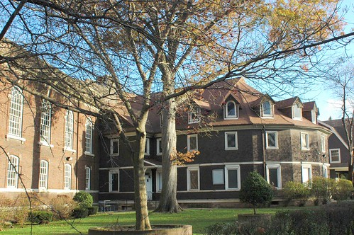
Tonight, Imagine Flatbush 2030 Workshop #3

Imagine Flatbush 2030 Logo

Tonight’s Imagine Flatbush 2030 meeting will take place at 6:00 pm at the Brooklyn College Student Center, 6th Floor, at East 27th St. & Campus Road (ramp entrance near Amersfort Place).

This video, composed of images and footage from the second workshop, held at Brooklyn College back in December, provides some information on the process. If you’re curious about the man behind the blog, I make two very brief appearances, presenting issues raised in the group I was in. From 2:00-2:04, transportation is mentioned. And from 2:23-2:29, I report retail affordability as an issue: “We don’t want all of our local businesses to be replaced by chain stores.” And I think I recognize my voice as the voiceover from 3:02 to 3:13.


Imagine Flatbush 2030 from MAS on Vimeo.

If you have not sent an RSVP and are interested in attending, please contact Sideya Sherman, at the Municipal Art Society (MAS) Planning Center, 212/935-3960 or via email at ssherman@mas.org.

Snacks and sandwiches will be served at tonight’s workshop.

Please be advised that there will be a supervised homework room provided for school aged children. If you need to bring a child, please contact us in advance.

Resource: DCP’s Census Fact Finder

Map of Brooklyn Census Tract 520 returned by the DCP Census Tract Finder when searching on the Q Train Cortelyou Road Station.
Brooklyn Census Tract 520

At last night’s Workshop #2 of Imagine Flatbush 2030, they had something new: a brief slide show of orientation information, similar in content to that presented at the first workshop, plus some census data about the study area. You can see some photos of these by Frank Jump, who attended last night’s workshop and happened to be in my breakout group, on his blog, Fading Ad Blog.

I just discovered that the NYC Department of City Planning (DCP) provides online access to census data in their Census Fact Finder. The finder is tabbed to provide searches by:

  • Street address
  • Community District
  • Point of Interest (not enough “points” to be widely useful)
  • Subway station

Except for Community District, once you’ve identified a point, you can view census data by a single Census Tract, by neighboring Census tracts within a .1 to .5 miles range you specify, or by Community District.

At the top of the resulting report is a map showing the point or area you selected and the matching census tracts. A pink dot identifies the focus, the selected tracts are highlighted in blue, and all visible tracts are numbered. Associated with the map are the usual zoom and navigation tools. It also provides tools to select or exclude additional census tracts.

For example, the map at the top of this post is returned when selecting the Q Train Cortelyou Road Station as the focus of the map. The finder returned Census Tract 520, which news reports in 2005 highlighted as the most diverse Census Tract in the entire United States:

In 1970, Census Tract 520 in Ditmas Park [sic] was 92.1% white. Less than a quarter of the population was foreign-born, and most of them were Italian and Jewish. Today, the neighborhood is a miniature United Nations, with nearly two-thirds of the population coming from other countries.

Although Elmhurst and Jackson Heights have a larger percentage of foreign-born residents, the city’s demographer, Joseph Salvo, said it’s the convergence of racial and ethnic diversity that distinguishes Ditmas Park.
In a Diverse City, Ditmas Park Takes the Cake, New York Sun, May 26, 2005

Note, however, that Census Tract 520 is not in the historic district of Ditmas Park. It comprises the eastern half of Ditmas Park West, my neighborhood neighbor to the south, plus the blocks between Newkirk and Foster Avenues.

Below the map in the report is a table showing all the census data, aggregated for the selected census tracts. The table is tabbed for the major categories of data available:

  • Demographic
  • Socio-economic
  • Age
  • Income in 1999
  • Labor
  • Education
  • Housing Characteristics
  • Housing Costs

For example, to examine the claim that this tract is the most diverse, let’s look at the demographic data:

Demographic Profile Tract(s) Brooklyn New York City
Total Population 4,399 2,465,326 8,008,278
Single Race, Nonhispanic: (by percentage)
White 19.3% 34.7% 35.0%
Black / African American 29.2% 34.4% 24.5%
American Indian and Alaska Native 0.3% 0.2% 0.2%
Asian 22.4% 7.5% 9.7%
Native Hawaiian and other Pacific Islander 0% 0% 0.0%
Some other Race 1.3% 0.7% 0.7%
Two or More Races, Nonhispanic 7.8% 2.8% 2.8%
Hispanic Origin (of any race) 19.8% 19.8% 27.0%

The “most diverse” claim arises from the observation that the demographic category comprising the largest single group, Black / African American, only comprises 29.2% of the population. Across the city as a whole, there is diversity. Queens has the largest percentage of foreign-born residents of all five boroughs. But when you get down to the level of a few blocks, what you usually see is a predominant group.


At last night’s workshop, at each breakout group, the facilitators asked each of us to briefly identify our main concern, our main wish or goal for Flatbush in the years to come. By the time it got around to me, I’d had time to practice in my mind what I wanted to say, and wrote it down in my notebook:

Diversity Without Disparity

And I explained that I mean this “in every way I can think of.” This captures the asset of diversity we enjoy today, one which I think most of those who’ve participated in the workshops so far value as well. It also presents the challenge: how can we mitigate existing disparities, and keep the gap from widening. How can we avoid becoming the victims of our own success as a vibrant, interesting, developing community?

Related Posts

Imagine Flatbush 2030

Links

Imagine Flatbush 2030 (Sponsored by the Municipal Art Society of NY) – Workshop #2, Brooklyn College, Frank Jump, Fading Ad Blog
Over 100 People Imagining Flatbush 2030, Brooklyn Junction
In a Diverse City, Ditmas Park Takes the Cake, Daniela Gerson, The New York Sun, May 26, 2005

Notes from Imagine Flatbush 2030 Workshop #1

Your host, reporting the observations of his breakout group to the larger assembly at IF2030 Workshop . Credit: Municipal Art Society.

Yesterday’s Brian Lehrer Show on WNYC has brought wider awareness of and interest in Imagine Flatbush 2030. For those who are curious about the process, or might even be interested in attending Workshop #2, here are the notes which the Municipal Art Society facilitators compiled from the first workshop back in November.

Imagine Flatbush 2030 kicked off on Monday, November 19 at Temple Beth Emeth, with a preliminary stakeholders meeting. (A list of approximately 150 stakeholders was cultivated with help from FDC, neighborhood groups, and elected officials. Stakeholders who attended were asked to serve as project ambassadors and assist with outreach for the next meeting.) [At least three of us who live within the study area and write about it on our blogs – Sustainable Flatbush, Brooklyn Junction, and I – attended the first workshop.] Approximately 50 of those invited attended—representing Brooklyn College, tenant associations, city government, homeowners associations, the local YMCA, merchants groups, community development groups, and civic and faith-based groups.

After an introduction by the Planning Center to MAS, Jane Jacobs, and the goals of the project, Elizabeth Yeampierre, Executive Director of UPROSE led a discussion of the meaning of neighborhood sustainability, the Mayor’s PlaNYC, and why neighborhoods needed to create their own agendas to work in tandem with the Mayor’s plan.

Attendees were asked to work in groups to brainstorm neighborhood assets and challenges, as a way of beginning a dialogue. Six groups produced observations that they first recorded on paper, then shared with the entire group at the end of the workshop. [A full transcript of all the notes from all groups will be available from MAS. I’ve asked for a copy as soon as its available. In my group, we covered both sides of two large sheets of paper!]

Shared observations about Flatbush’s assets included:

  • diversity (cultural; economic; ethnic; racial; religious);
  • proximity to Prospect Park;
  • good public transportation;
  • good schools;
  • proximity to Brooklyn College;
  • distinctive, historic neighborhood character;
  • strong and active community-based organizations;
  • aesthetically pleasing;
  • long tenure of many residents;
  • and locally-owned businesses.

Shared observations about challenges included:

  • lack of neighborhood parks;
  • school overcrowding;
  • lack of space for artists;
  • lack of active ways to engage youth;
  • lack of space for public assembly, such as community, senior, and youth centers; gentrification;
  • lack of affordable housing;
  • traffic;
  • achieving energy efficiency in buildings;
  • gang activity (both real and perceived);
  • lack of parking;
  • and inadequate sanitation in some areas.

Some interesting macro-level impressions: the neighborhood is large and varies in character and composition from place to place and consequently assets and challenges vary from place to place.

Next step: Workshop 2 at Brooklyn College Conference Center, Wednesday, December 12. [Note: This will start at 6:30pm, not 7pm as reported in these notes as sent out to Workshop participants.] Agenda: public forum to identify sustainability goals.

Related Posts

Posts tagged “Imagine Flatbush 2030”

Links

Municipal Art Society
Flatbush Development Corporation
Sustainable Flatbush
Brooklyn Junction

12/12: Imagine Flatbush 2030 Workshop #2

Imagine Flatbush 2030 Winning Logo, Credit: Imani Aegedoy, 11-9-2007
Imagine Flatbush 2030 Logo
Next week, on Wednesday, December 12, the second community workshop of Imagine Flatbush 2030 will be held at Brooklyn College:

Come and participate in a special dialogue about the future of Flatbush. The Flatbush Development Corporation (FDC) and the Municipal Art Society (MAS) are inviting you to take part in Imagine Flatbush 2030—a community visioning and dialogue process—designed to get you together with other Flatbush community members to collectively create a more sustainable neighborhood. If you care about the environment, community health, protecting diversity, ensuring affordable housing and a whole host of other community issues, this is the meeting for you!

When: Wednesday, December 12th @ 6:30 pm
Where: Brooklyn College Student Center, 6th Floor
East 27th St. & Campus Road
(ramp entrance near Amersfort Place, see map below)

The star highlights the location of IF2030 Workshop . The closest subway stop is the 2/5 Brooklyn College-Flatbush Avenue / Nostrand Avenue station. North is to the lower-right in this map.
Imagine Flatbush 2030: Location of Workshop#2

For more information and to RSVP, please contact Sideya Sherman, at the MAS Planning Center, at 212/935-3960 or via email at ssherman@mas.org.

Please be advised that there will be a supervised homework room provided for school aged children. If you need to bring a child, please contact us in advance.

Refreshments will be served

Related Posts

IF2030 on the Brian Lehrer Show, earlier today
The Albemarle Road Pedestrian Bridge, November 25
Imagine Flatbush 2030, November 20

Links

Imagine Flatbush 2030, Municipal Art Society

TODAY: Imagine Flatbush 2030 on the Brian Lehrer Show

UPDATE: The podcast is available from WNYC’s Web site, or through the widget below.


I just learned of this a few minutes ago. Today on the Brian Lehrer Show:

Susan Siegel, outgoing executive director of the Flatbush Development Corporation (FDC)and Zenobia McNally, local resident and business owner and Eve Baron, director of The Municipal Art Society Planning Center and the project manager for Imagine Flatbush 2030, discuss their efforts to create a community-directed development plan for Brooklyn’s Flatbush neighborhood.

The Brian Lehrer Show airs weekdays at 10AM on 93.9 FM and AM 820 and Tuesdays through Saturdays at 1AM on AM 820. The call-in number is 212-433-9692 (or 212 433 WNYC).

Related Posts

The Albemarle Road Pedestrian Bridge, November 25
Imagine Flatbush 2030, November 20

Links

Making Jane Jacobs Proud in Flatbush, The Brian Lehrer Show
Imagine Flatbush 2030, Municipal Art Society

Forgotten Flatbush: The Albemarle Road Pedestrian Bridge

In the first Imagine Flatbush 2030 workshop, we enumerated “Assets” and “Challenges”. At our table – and it sounded like the experience was shared at others’ – where someone lived emerged as a primary determinant of what appeared in which category. Sometimes shared concerns, such as transportation, appeared as both an asset and a challenge, depending on where one lived. It became clear to me that the lines can be sharply drawn, sometimes block-by-block.

I’m a newcomer to the area, having moved here only in Spring of 2005. I researched more and more about the area and its history as we committed to buying a home and moving here. I’ve still only visited a small portion of Flatbush. IF2030 is making me curious about exploring more of it.

Part of what I want to explore more of is literally “on the other side of the tracks” from where I make my home. The B/Q subway line runs through this neighborhood as an open trench. There are several places where there is no crossing, and the cut forms a geographical barrier, a steel river, separating one side from the other. It wasn’t always so. With homage to Forgotten NY, here’s a little piece of Flatbush that’s not quite forgotten, still part of living memory, the Albemarle Road pedestrian bridge.

Google Map of the location of the old Albemarle Road pedestrian bridge. 143 Buckingham Road is also highlighted; it’s a landmark in all the historical photos of this crossing. The markers show where I took the photos for this article.

View Larger Map

The BMT as I remember — never rode it much, but had relatives on East 17th & Beverley Road. We would always go to the Albemarle Road footbridge by the tennis courts over the BMT cut, and watch the trains.
– Steve Hoskins, SubTalk Post #93389, NYC Subway

Eastern Dead End of Albemarle Road at Buckingham Road. 143 Buckingham Road is at the left of the photograph.
Dead End, Albemarle Road at Buckingham Road

Western foundation of Albemarle Road Pedestrian Bridge

“I seem to have a memory – or is it just a dream? – going back to my earliest childhood, associated with a place about a mile in a different direction from where I lived, towards Prospect Park: it is a stretch of about five blocks of Albemarle Road, going from the Brighton subway underpass to Coney Island Avenue. One got there from our side of the subway tracks by crossing over on a small footbridge. On the far end of the bridge, Albemarle Road suddenly widens, and in the middle of it there is a traffic island, covered with trees and extending a 11 the way to Coney Island Avenue; there are also trees on both sides of the street. My first encounters with this scene are in my memory entirely intermingled with my dreams of it, a recurring vision of overwhelming loveliness at the edge of things, beyond which something entirely new and different must lie.”
– Ronald Sanders, A Brooklyn Memoir, via Living in Victorian Flatbush

Western Dead End of Albemarle Road near East 17th Street. 143 Buckingham Road is at the right of the photograph, across the tracks.
Western Dead End, Albemarle Road, near East 17th Street

East Foundation of Albemarle Road Pedestrian Bridge. 143 Buckingham Road is in the center, across the tracks.
East Foundation of Albemarle Road Pedestrian Bridge

Albemarle Road is interrupted by the subway cut for the B/Q lines. In the late 19th Century, several rail lines were developed to take passengers from the City of Brooklyn, what we now think of as downtown Brooklyn, through the other villages and towns such as Flatbush, to the beach resorts on Coney Island and Brighton Beach. By the 1870s the Brooklyn Coney Island Railroad ran along Coney Island Avenue. By the 1890s, the Brooklyn, Flatbush and Coney Island Railroad (BF&CI) ran along what is now the current route of the B/Q subway line. Most of Flatbush was still farmland at the time. When the Flatbush farms were sold and the area was developed at the turn of the 20th Century, the tracks still ran at grade.

In this 1873 map of Flatbush, Prospect Park and the Parade Grounds are already laid out to the north, and the Brooklyn Coney Island Railroad runs along Coney Island Avenue. On this map, Parkside Avenue is named Franklin Avenue, Church Avenue is named Church Lane, and Cortelyou Road is named Turner Harrow (or Narrow?) Lane. The Waverly Avenue shown on this map no longer exists; it’s later replaced by Albemarle and Beverly Roads Road, whose future locations are shown, but neither named nor yet built. The future route of the B/Q line is not shown. The families whose landholdings and houses appear on this map lent their names to several streets and neighborhoods: Turner, Hinkley, Ditmas and Vanderveer.
Map of Flatbush, Brooklyn, 1873

In an 1888 USGS Survey Map of Brooklyn, just a small portion of which is shown here, Waverly Avenue has been “de-mapped.” The roads built in its place, unnamed on this map, are Avenues B and C; these will be renamed later to Beverly and Cortelyou Roads. Between them run East 11th through East 14th Streets; in the early 1900s, these will be renamed to Stratford, Westminster, Argyle and Rugby Roads to cash in on the cachet of Prospect Park South. The BF&CI, which began service in July 1878, is also now in place. East of that, the eastern half of Avenue A (Albemarle Road) has been built, along with East 17th through 19th Streets.
Detail, 1888 USGS Survey Map of Brooklyn

Through the early 1900s, all these railroad lines ran at grade, at street level. There were also trolley lines, at first horse-drawn, then later electrified, on many of the crossing streets. Development brought a burgeoning residential population, more traffic, and more traffic conflicts and accidents. The decision was made to separate the rail and street traffic by moving them to different levels, passing above and below each other.

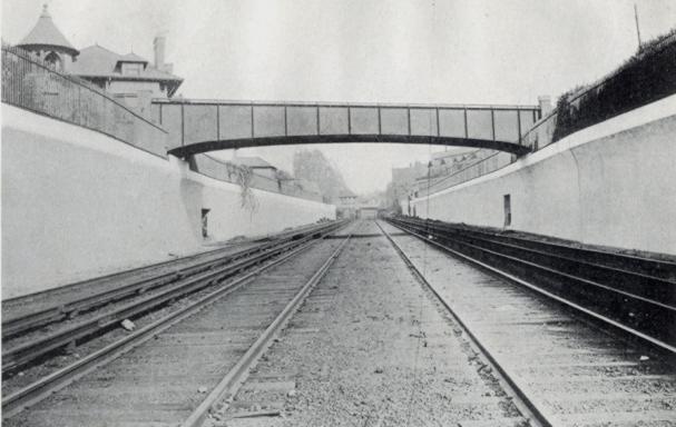
This photo from the 1918 “Reports of the Brooklyn Grade Crossing Elimination Commission” shows the Albemarle Road Footbridge. The line has been widened to four tracks and now runs below grade. Today, the local Q train runs on the outer tracks, while the express B runs on the inner tracks. 143 Buckingham Road is visible on the upper left of the photograph. Thanks to Art Huneke for permission to use this photograph. This photo appears on his page Brighton Beach Line, Part 3.
Albemarle Road Footbridge

The physical contrasts could hardly be stronger across the tracks: a wide, tree-lined boulevard with large, detached wood-frame houses on one side, and tall, multiple-unit residential buildings with few trees on the other. It is tempting to imagine what it would be like to restore the pedestrian bridge, eliminating at least a geographical barrier between these two halves of the same neighborhood. Would it help us to make other connections, to recognize our common assets and challenges, and work together to create a future we can all live with?

Related posts

Imagine Flatbush 2030

Links

My Flickr photo set
Brighton Line, NYC Subway
ARRT’s Archives, Art Huneke’s Web site
Rapid Transit Net
The Brooklyn Grade Crossing Elimination Project, 1903-1918

Imagine Flatbush 2030

Update 2007.12.13: Added link for all related posts on Imagine Flatbush 2030.


Imagine Flatbush 2030 Winning Logo, Credit: Imani Aegedoy, 11-9-2007

Last night I attended the first of a series of four workshops for Imagine Flatbush 2030. Brooklyn Junction and
Sustainable Flatbush were also in attendance. Sponsored by the Municipal Arts Society (MAS) and Flatbush Development Corporation (FDC), IF2030 is a community-based process to develop goals and indicators to inform any future planning for the area:

The Mayor’s PlaNYC2030 is a citywide sustainability agenda that lays the groundwork for achieving and maintaining affordable housing, open space, good transportation, clean air, water, and land and reliable energy. It affords an enormous opportunity to rethink the development of the city. As part of Jane Jacobs and the Future of New York, MAS will work with the residents, business owners, and civic leaders of Flatbush, Brooklyn, with the partnership of the Flatbush Development Corporation, to assist in creating neighborhood sustainability goals and tools to measure progress toward consensus-based goals.
Imagine Your Neighborhood 2030: a Community Visioning Project

The project study area [PDF] comprises the northern half of Brooklyn’s Community District 14, north of the old LIRR right-of-way which runs between Avenues H and I.
Northern Half of Brooklyn's Community District 14

There will be three more meetings, one each in December, January and February. The final report will be published in March 2008. The next meeting will be Wednesday, December 12, likely to be hosted at Brooklyn College. If you live or work within the study area and would like to get involved, contact Sideya Sherman of MAS [ssherman at mas dot org] or Aga Trojniak of FDC [trojniak at fdconline dot org].

Flatbush is one of the most culturally and ethnically diverse neighborhoods in the city, growing at a rate of eight percent annually, and mirroring the needs and attributes of a growing population within a district that is both architecturally and historically distinct. Yet the lack of affordable housing undermines the ability of the neighborhood to stay diverse, the resident to open space ratio is among the highest in the city, and heavy vehicular traffic compromise the quality of life.

This area is one of great diversity: ethnic, cultural, religious, and other. It is also an area of great disparity in economics, services, and environmental amenities.

“Welcome” in eleven languages on street sign for Newkirk Family Health Center, 1401 Newkirk Avenue
Newkirk Family Health Center, 1401 Newkirk Avenue

Kings Theater, Flatbush Avenue

GreenBranches, Flatbush Branch, Brooklyn Public Library

Da Pride a Flatbush, FDNY Engine 281
Da Pride a Flatbush

Greenmarket, Cortelyou Road

Flatbush-Tompkins Congregational Church, Ditmas Park
Flatbush-Tompkins Congregational Church

599 Coney Island Avenue

2274 Church Avenue
2274 Church Avenue

Christ My Sufficiency, Brooklyn Foursquare Church, 603 Rugby Road

Townhouses in Caton Park

Flatbush E-Cycling, Cortelyou Road
Flatbush E-Cycling

Together We Can Change the World

Susan Siegel of FDC opened the meeting and introduced the MAS team. Conducting the meeting on behalf of MAS were:

  • Eve Barron
  • Sideya Sherman
  • Lacey Tauber
  • Elizabeth Yeampierre (Executive Director, UPROSE)
  • Juan-Camillo Osario

The IF2030 Advisory Committee includes:

  • State Senator Kevin Parker
  • State Assembly Member Rhoda Jacobs
  • State Assembly Member Jim Brennan
  • Brooklyn Borough President Marty Markowitz
  • City Council Member Mathieu Eugene
  • Ms. Anne Pope (Sustainable Flatbush)
  • Ms. Gretchen Maneval (Center for the Study of Brooklyn, Brooklyn College)

Contact

Imagine Flatbush 2030 c/o
Municipal Art Society
457 Madison Avenue
New York, NY 10022
Tel: 212.935.3960, x259
Fax: 212.753.1816

Related Posts

Imagine Flatbush 2030

Links

Municipal Arts Society (MAS)
Flatbush Development Corporation
UPROSE
PlaNYC2030