State of Flatbush/Midwood

The Brooklyn Daily Eagle reported yesterday that this report was “just released”, although it was released back in April [PDF]. Nevertheless, the State of New York City’s Housing and Neighborhoods 2006 report, from NYU’s Furman Center for Real Estate and Urban Policy, is worth a second look (or first look if, like me, you somehow missed the full report the first time).

In addition to statistics and trends by borough, they include the details and rankings by Community District. Most of Victorian Flatbush lies in the northern half of CD14, which covered Flatbush and Midwood:

Flatbush/Midwood tops the citywide rankings in price appreciation and median price per unit for single-family homes. Median incomes have been trending upward, poverty has declined by 3 percentage points and overall income disparities in the district have decreased. CD 214 is Brooklyn’s most racially diverse district and almost 60% of its households are immigrant-headed. CD 214 is the borough’s second densest district and has a very low proportion of open space or vacant land compared to the rest of the borough. The housing stock in CD 214 is in worse shape than average—serious housing code violations are high, and although a high percentage is rent-regulated, little subsidized housing is available.
– State of NYC’s Housing and Neighborhoods 2006, Brooklyn Community District 14, Flatbush/Midwood [PDF]

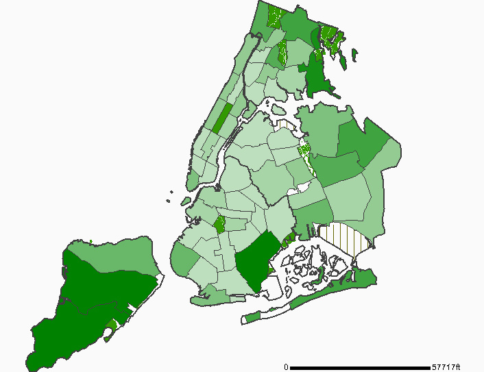
At just .77 acres of open space per 1,000 residents [PDF], CD14 ranks 47th out of 59 Community Districts. Worst off across the whole city is East Flatbush (Brooklyn CD17), with just .11 acres for 1,000 residents.

Generated with NYCHANIS.
Open Space by Community District, NYC

The Web site for the report has a complete index of reports by Community District.

Links:

State of New York City’s Housing and Neighborhoods 2006
The Furman Center for Real Estate and Urban Policy
New York City Housing and Neighborhood Information System (Requires free registration)

Illegal Conversions Kill

Update, September 25: This morning’s news reports have additional information about the living situation in the building.


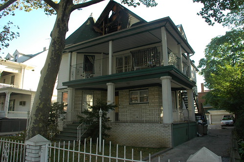
251 East 19th Street, the morning of September 25
251 East 19th Street

Shortly after midnight this morning (September 24), a fire broke out in a house several blocks from mine, in the adjacent neighborhood of Beverly Square East, one of the neighborhoods of free-standing, wood-frame Victorian homes in the larger area known as Victorian Flatbush. Early reports misidentified the neighborhood as Kensington. Some reports are still misidentifying the neighborhood as Ditmas Park, which is a historic district whose northern boundary lies two blocks to the south.

The immediate cause of the fire was an electric malfunction. The deeper cause is the illegal conversion of a single-family home to multiple units. The property is on file as a single residential unit, a single-family home. There were as many as 6 people living on the attic floor where the fire broke out; three of them, aged 76, 50 and 12, were killed by this fire, and one remains in serious condition. The only working smoke detector was on the first floor.

At least one report cites “numerous violations” against the owner of the building. However, most of the violations and complaints I can find are all several years old, and were all “cured” or “resolved”. There is one active complaint, created today, for failure to maintain a fire-damaged building.

I learned from news reports the morning of the 25th that this was not an absentee landlord situation. The 11 people who lived on the top two floors of the building, including the three killed, are part of the owner’s extended family. Three more people live on the first floor.

The existing system of DOB violations is broken. Fines and liens are insufficient deterrents. DOB and FDNY must have the authority to obtain warrants to enter buildings to investigate outstanding safety and occupancy violations. Owners’ income from such buildings must be seized, paid into escrow, until the DOB and FDNY certify that life-threatening conditions have been resolved.

Links:

Hero boy dies trying to save 2 from fire (NY Daily News, September 25)
Boy, 12, dies in fire trying to save grandmother (Newsday, September 25)
Fire Kills 3, From 3 Generations, in a Crowded House in Brooklyn (New York Times, September 25)
Man Rescues Teenager From Blazing Brooklyn Rooftop (New York Sun, September 25)
Deadly fire rips through a home in Brooklyn (7Online, ABC local affiliate)
FDNY Says Electrical Wiring To Blame For Deadly Brooklyn Fire (NY1 News)
Google News

Gowanus Nursery under threat

Updated 22:00 EDT: Added links, maps, and legend.

Gowanus Nursery, as it appeared on their opening day this Spring
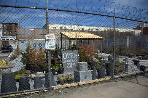
Gowanus Nursery
I received the following email this afternoon through the Gowanus Nursery mailing list.

On Wednesday August 22, a small group of business owners, employees and clients attended a city planning meeting that was to decide the fate of a few parcels of land located on Summit and Carroll streets.

The likely outcome is that Gowanus Nursery (45 Summit Street) will be forced to move, once again.

Remarkably, this change is a thinly disguised ‘spot zoning’ to allow for a residential development in a grandfathered commercial zone. This action, in the words of Community Board 6, has been the most aggressive use of ULURP (re-zoning) procedures that the current board has ever seen, forcing out active and flourishing businesses to make way for residential development.

Borough President Marty Markowitz’s recommendations suggest that the nursery occupied lot provides property owners the opportunity to lease under-developed land with minimal investment (part true since the only investment came in the form of our own labor and financial funding.) There seems something fundamentally wrong with labeling well-used open ‘green’ space as ‘under-developed’.

On a personal note, I am frustrated not only by the futility of the work we have already logged here, but also by the casual way that zoning change is happening in ‘our’ neighborhood. Last year, you, my customers and colleagues came to offer your services during the first move. Now, I ask for your help to help save this ‘green oasis’ from perishing in the changes affecting all of Brooklyn.

One of the questions asked by the city planning commissioners was “We have heard a lot of testimony about how this is the ‘best’ nursery, could you please give some definite examples to support this statement?” Well, we hope that our garden making has been successful; stimulating ideas and offering advice, suggesting different ways of seeing plants and how they affect our environment directly and indirectly. Of course, something akin to a mission remains: providing to gardeners experience-based knowledge and the broadest selection of perennial plants for Brooklyn gardens.

We hope that you can take the time to email the following parties to let them know in a few words what makes us an important part of the neighborhood and the whole Brooklyn experience.

Council representative – Bill de Blasio, deblasio@council.nyc.ny.us;
City Council Speaker – Christine Quinn, quinn@council.nyc.ny.us;
Land Use Committee Chairperson – Melinda R. Katz, katz@council.nyc.ny.us;
Mayor Michael Bloomberg

The following are some statements to paste into your appeal:

It’s impossible to run a nursery without land.

Businesses such as these provide necessary services to the community, and are the reason we choose Brooklyn.

Please help Gowanus Nursery to remain a Brooklyn institution.

I located a map of the proposed zoning change. This was certified to begin ULURP as far back as May 14th of this year.

Proposed Zoning Change Affecting Gowanus Nursery

The area enclosed by the dotted line is proposed to be rezoned by changing from an M1-1 District to an R6 District. The heavy solid lines indicate where the Zoning District Boundaries would like after the proposed zoning change. To become effective, the proposed changes must be approved first by the City Planning Commission, then the City Council.

Here’s a map, courtesy of OASIS-NYC, that shows the current uses of 45 Summit Street and nearby properties:

Gowanus Nursery, 45 Summit Street

Legend:
Legend image1 & 2 Family Residential
Legend imageMulti-family Residential (3 or more Residential Units)
Legend imageMixed Use (Residential and Commercial)
Legend imageCommercial
Legend imageInstitutions
Legend imageTransportation & Parking
Legend imageIndustrial (corresponds to Zoning’s “Manufacturing” designation)
Legend imageVacant Lots

Comparing these two maps, it appears that most of the properties along Carroll Street within the proposed zoning change are already in residential use. The proeprties along Summit Street, however, are in industrial use, consistent with their M-1 Zoning designation.

The question of whether or not Gowanus is “the best” nursery is a red herring. This seems like a suspiciously convenient carve-out for someone. Who is going to reap the windfall from eminent domain-style tactics that strip privileges from one group and class of residents to benefit another?

Links:
Landscape and Politics in Brooklyn’s City Council District 40

Brooklyn City Council District 40Next week, on Tuesday, February 20, there will be a special election to replace Yvette Clarke as Brooklyn’s 40th District City Council Member. Clarke was elected to Congress in last year’s elections. The council member elected on February 20 will serve only until the end of 2007. A general election in November will elect the member to serve the remainder of Clarke’s unfinished term.

Last week I attended a Candidates’ Forum on Preservation and Development. The Historic Districts Council, a sponsor of the Forum, has issued a Preservation Voter Guide.

There are several landmarked historic districts within District 40, and hopefully another soon. Still, most of the Victorian Flatbush neighborhoods are at risk of being lost forever due to inappropriate zoning and development.

NYC asks us to imagine What kind of city we want to live in by 2030. What happens to this area in the next decade will determine not only what happens by 2030, but this century and beyond. The neighborhoods of Victorian Flatbush are not only worth preserving, it’s critical to the future of this area that we do so. It’s not just about pretty houses, or property values. It’s about open space and shade. It’s about the rates of asthma and respiratory disorders. It’s about moderating surface temperatures by preserving and managing the urban forest, reducing heating and cooling demands. It’s about how many people will die in the heat waves we will experience by the end of the century. It’s about the quality of life for the entire area, and whether or not it will be livable in the future.


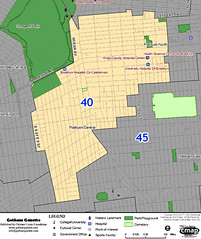
This map shows the locations of schools and parks in City Council District 40. Schools are indicated with blue dots. The green labels identify the location of parks. Open space, including cemeteries, ball fields, and so on, are outlined in green. Prospect Park abuts District 40 on the northwest. The Parade Ground south of that is ballfields. Other than that, there is a near complete absence of parks within District 40.

Brooklyn City Council District 40: Schools and Parks

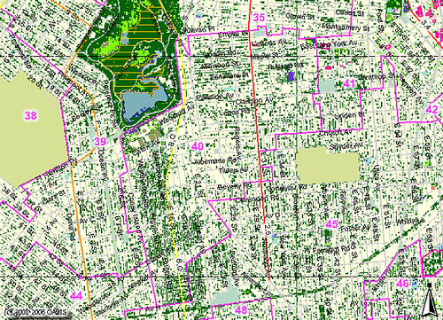
This map shows landcover classification in District 40. Dark green areas are trees and forest. Light green areas are grassland, fields and such. Everything else is classified “impervious”, ie: buildings, streets, sidewalks, pavement, etc.

Brooklyn City Council District 40: Classified Landcover

South of Prospect Park, note the interrupted band of dark green that extends to the south boundary of the District. These trees provide the only greenery and shelter in District 40. This area is the lungs of Flatbush.

Now we zoom in on my little neck of the woods, the Victorian Flatbush neighborhood of Beverly Square West. This map shows the outlines of buildings and the landcover classification. At this scale, it becomes clear that it is the trees on private property, not street trees, and certainly not parks or “open areas”, that provide most of the tree cover.

Beverly Square West: Buildings and Classified Landcover

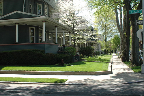
And this is what it looks like from the ground. These two photos show the view from the same street corner on my block, as it looks in Spring and Fall.

DSC_0498
Stratford Road, East side, looking South from the corner of Slocum Place

With no parks for blocks around, and few playgrounds, it’s no wonder that parents come to our streets to stroll their babies and walk their children. It’s the only green space within walking distance for many people.

Links:

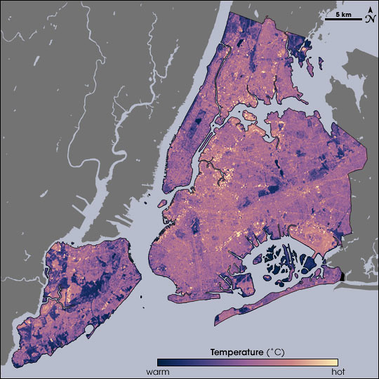
News, August 1, 2006: NASA Earth Observatory Maps NYC’s Heat Island, Block by Block

Timely enough, given the record temperatures we’re experiencing this week. Tomorrow’s forecast has been “upgraded” from what I reported yesterday: the THI may reach 117F tomorrow.

Temperatures in New York City as measured by Landsat on August 14, 2002, at 10:30am, during a heat wave. Cooler temperatures are blue, hotter are yellow.
Source: NASA Earth Observatory. Map by Robert Simmon, using data from the Landsat Program.
NASA Map of Surface Temperatures in New York City, 2002-08-14

Temperatures in New York City as measured by Landsat on August 14, 2002, at 10:30am, during a heat wave. Cooler temperatures are blue, hotter are yellow.
Source: NASA Earth Observatory. Map by Robert Simmon, using data from the Landsat Program.
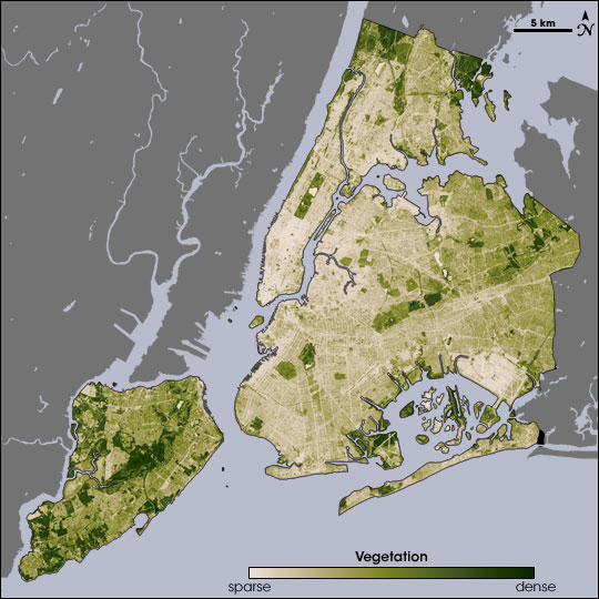
NASA Map of Surface Vegetation in New York City

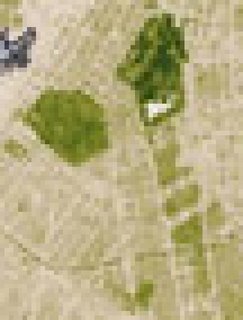
The ability of vegetation to moderate urban temperatures is graphically demonstrated in these paired images from NASA’s Earth Observatory. The spatial resolution of these images is 60 meters per pixel. At that scale, I can just about make out the block where I garden:

Closeup of the vegetation map, centered on central Brooklyn. The green area at the left is Greenwood Cemetery. Prospect Park is the dark green area at the top; the white area within it is Prospect Lake.

Below the park, to the south, Victorian Flatbush, with its tree-lined streets, detached wood frame houses, and front lawns, spreads out as a series of olive green areas. The beige areas in-between the olive are rowhouses and apartment buildings. You can even make out a curving green line across the southern end of this area: That’s the old LIRR right-of-way, long abandoned, and overgrown with trees.

NASA has just published a report on urban heat islands highlighting the research of Stuart Gaffin, an associate research scientist with the Earth Institute at Columbia University in New York City, and his colleagues:

In the summer of 2002, Gaffin and his colleagues used satellite temperature data, city-wide land cover maps, and weather data, along with a regional climate model to identify the best strategies for cooling the city. The team estimated how much cooling the city could achieve by planting trees, replacing dark surfaces with lighter ones, and installing vegetation-covered “green roofs.”
The team studied the city as a whole, as well as six “hotspot” areas—including parts of Manhattan, the Bronx, Queens, and Brooklyn—where air temperatures near the ground were higher than the city-wide average. Each area was serviced by Con Edison, the local power company, so the scientists could compare electricity use. Each area also had available space so that the mitigation strategies the team considered could be modeled in the study and potentially implemented later on.
August 14 fell on one of the hottest heat wave days in New York’s summer of 2002, making it a good day to take the city’s temperature. Measuring the temperature of every last sidewalk, street, parking lot, roof, garden, and grassy area in an entire city isn’t easily done from the ground, so the researchers relied on NASA to take the city’s temperature from the sky. NASA’s Landsat Enhanced Thematic Mapper collected thermal infrared satellite data. …
Beating the Heat in the World’s Big Cities

Related posts

Urban Forestry