Gardening as if our lives depended on it

2014-10-13: I just discovered that none of the original links are good. Two web sites linked from this post – Climate Choices, and the Northeast Climate Impacts Assessment (NECIA) – now redirect to the Union of Concerned Scientists (UCS).


I first started writing this post in the Fall of 2006. I drafted it in October 2006, but never published it. I think I was too overwhelmed by the impact of what I was writing to release it. The IPCC report has been issued since then. What I wrote over a year ago no longer sounds so alarmist to me. A post on Garden Rant spurred me to dust this off and get it out there, however imperfect I may think it is.


There’s a lot to this, and I’ve gone through some changes just to take it all in. Here’s the short version:

  • Climate change is inevitable. It’s happening already. We can’t undo the damage we’ve already caused. We can only ride it out.
  • If we continue as we have, the impacts will be severe. It’s going to get really, really bad.
  • Actions we take now can reduce the impact. If we start doing things differently now, it won’t get as bad as it could. We can affect the future.

There are those who cling, at times violently, to ignorance and dismissal of the facts of climate change induced by human activity. “De-nial ain’t just a river in Egypt.” It reminds me of the classical stages of grieving described 40 years ago by Dr. Elisabeth Kübler-Ross, all of which are demonstrated in different responses expressed around this topic:

  • Denial. The three-dog argument – denial, minimization, projection – applies here: There’s no climate change (it’s not a problem). The climate change is within historical ranges (it’s not so bad). It’s a natural process (it’s not my problem).
  • Anger. Protest, boycott, rage against the machine, fight the system, fight the man.
  • Bargaining. Carbon “credits” is the most obvious example. Little different from buying indulgences from a corrupt church.
  • Depression. There’s nothing we can do about it.
  • Acceptance. It’s going to happen. It’s happening. Now what do we do about it?

In July 2006, I wrote about the Bemidji Statement on Seventh Generation Guardianship:

The seventh generation would be my great-grandchildren’s great-grandchildren’s children. (If I had, or were going to have, any children to begin with.) If a generation occurs within the range of 20-30 years, we’re talking 140-210 years. Call it 175 years from now.

It’s the year 2181. It’s hard for me to imagine anything I can do to stave off or reduce the multiple disasters which we will have caused.

That was the voice of depression. I feel some hope now. The changes I make now, the work I do now, can make a difference. But only if I accept what’s going to happen if I do nothing.


A report (PDF) issued in October 2006 details what’s going to happen to the climate of the Northeastern United States – Maine, New Hampshire, Vermont, Massachusetts, Rhode Island, Connecticut, New York, New Jersey, and Pennsylvania – in this century:

The Northeast Climate Impacts Assessment (NECIA) is a collaboration between the Union of Concerned Scientists and a team of independent experts using state-of-the-art tools to assess how global warming will affect the Northeast United States following two different paths: A higher emissions path with continued rapid growth in global warming pollution, and a lower emissions path with greatly reduced heat trapping emissions.


The goal of this assessment is to provide opinion leaders, policymakers, and the public with the best available science as we make informed choices about reducing our heat-trapping emissions and managing the changes we cannot avoid.
Climate Choices in the Northeast, Climate Choice

The [Northeast] region, comprising nine of the 50 US states, is critical, since it alone is the world’s seventh-largest emitter of greenhouse gases, just behind the entire nation of Germany and ahead of all of Canada …


Climate changes already under way will continue to accelerate in the next few decades, whether the high-emissions or low-emissions path is taken, but the results will diverge dramatically by the time today’s newborns reach middle age, the study found.
US Northeast Could Warm Drastically by 2100, PlanetArk

Even the more optimistic, lower-emission scenario – if we aggressively reduce our contributions to global warming – is concerning. If we do nothing, NYC will become unliveable by the end of this century.

The higher-emission scenario … represents a future with fossil fuel-intensive economic growth and a global population that peaks mid-century and then declines. In this scenario, concentrations of atmospheric carbon dioxide (the main heat-trapping gas) reach 940 parts per million (ppm) by 2100—more than triple pre-industrial levels.


The lower-emission scenario … also represents a world with high economic growth and a global population that peaks by mid-century, then declines. However, the lower-emission scenario includes a shift to less fossil fuel-intensive industries and the introduction of clean and resource-efficient technologies. Atmospheric carbon dioxide concentrations reach 550 ppm by 2100, about double pre-industrial levels. Current carbon dioxide concentrations stand at 380 ppm (about 40 percent above pre-industrial levels).
Scenarios and Models, Climate Choice


Over the past 40 years, NYC has averaged 15 days over 90F, and 2 days over 100F each year. In the lower-emission scenario, by the end of the century NYC will have 39 days over 90F, and 7 days over 100F. Under higher (unreduced) emissions, NYC will have 72 days over 90F (five times the current historical average), and 25 days over 100F (ten times the current historical average).

While these urban temperature projections seem to include the overall urban heat island effect, they do not describe surface temperatures, which I wrote about in August 2006. Rooftop temperatures can exceed 150F in the summer. These effects will be amplified even more when the city bakes for weeks and months without relief. We can expect heat-related deaths in the tens of thousands. Heat-related structural failures are not out of the question; the infrastructure of the city was not built with these conditions in mind.

What about winter temperatures? These will also increase. They have already increased by 3.8F from 1970 to 2000. Under the lower-emission scenario, average winter temperatures over the region will increase by 5-7.5F. With higher emissions, we will see 8-12F increase in winter temperatures. The USDA Hardiness Zones are delineated by 5F, so this means my garden is moving 1-2 zones this century, from Zone 7a to Zone 7b or 8a.

For another point of comparison, when things were that much cooler than they are now, NYC was under a mile of ice.


The temperature projections do not include the apparent temperature caused by increased humidity – the heat index – which can make it feel up to 20F hotter. Warmer air can hold more moisture. The increase in humidity will ramp up the heat index faster than the actual temperature.

This map represents how climate will shift in the NYC area through this century. This includes consideration of the heat index. Basically, we’ll be somewhere between Virgina Beach and Savannah.


Thanks to PlanetArk for bringing this to my attention
[bit.ly]
[goo.gl]

Related Posts

Imagine Flatbush 2030, November 20, 2007
Barbara Corcoran Hates the Earth, November 18, 2007
Preserving Livable Streets, November 7, 2007
2006 was the fifth-warmest year on record, February 20, 2007
The IPCC Report: Grief & Gardening #6, February 4, 2007
Buying Indulgences: The Carbon Market, November 23, 2006
NASA Earth Observatory Maps NYC’s Heat Island, Block by Block, August 6, 2006
The Bemidji Statement on Seventh Generation Guardianship, July 22, 2006

Links

Northeast Climate Impacts Assessment (NECIA) (link corrected 2014-10-13)
Full report (PDF, 159 pages, link corrected 2014-10-13)
Summary (PDF, 8 pages, link defunct 2014-10-13)
Climate Choice (link defunct, 2014-10-13)
Union of Concerned Scientists

Imagine Flatbush 2030

Update 2007.12.13: Added link for all related posts on Imagine Flatbush 2030.


Imagine Flatbush 2030 Winning Logo, Credit: Imani Aegedoy, 11-9-2007

Last night I attended the first of a series of four workshops for Imagine Flatbush 2030. Brooklyn Junction and
Sustainable Flatbush were also in attendance. Sponsored by the Municipal Arts Society (MAS) and Flatbush Development Corporation (FDC), IF2030 is a community-based process to develop goals and indicators to inform any future planning for the area:

The Mayor’s PlaNYC2030 is a citywide sustainability agenda that lays the groundwork for achieving and maintaining affordable housing, open space, good transportation, clean air, water, and land and reliable energy. It affords an enormous opportunity to rethink the development of the city. As part of Jane Jacobs and the Future of New York, MAS will work with the residents, business owners, and civic leaders of Flatbush, Brooklyn, with the partnership of the Flatbush Development Corporation, to assist in creating neighborhood sustainability goals and tools to measure progress toward consensus-based goals.
Imagine Your Neighborhood 2030: a Community Visioning Project

The project study area [PDF] comprises the northern half of Brooklyn’s Community District 14, north of the old LIRR right-of-way which runs between Avenues H and I.
Northern Half of Brooklyn's Community District 14

There will be three more meetings, one each in December, January and February. The final report will be published in March 2008. The next meeting will be Wednesday, December 12, likely to be hosted at Brooklyn College. If you live or work within the study area and would like to get involved, contact Sideya Sherman of MAS [ssherman at mas dot org] or Aga Trojniak of FDC [trojniak at fdconline dot org].

Flatbush is one of the most culturally and ethnically diverse neighborhoods in the city, growing at a rate of eight percent annually, and mirroring the needs and attributes of a growing population within a district that is both architecturally and historically distinct. Yet the lack of affordable housing undermines the ability of the neighborhood to stay diverse, the resident to open space ratio is among the highest in the city, and heavy vehicular traffic compromise the quality of life.

This area is one of great diversity: ethnic, cultural, religious, and other. It is also an area of great disparity in economics, services, and environmental amenities.

“Welcome” in eleven languages on street sign for Newkirk Family Health Center, 1401 Newkirk Avenue
Newkirk Family Health Center, 1401 Newkirk Avenue

Kings Theater, Flatbush Avenue

GreenBranches, Flatbush Branch, Brooklyn Public Library

Da Pride a Flatbush, FDNY Engine 281
Da Pride a Flatbush

Greenmarket, Cortelyou Road

Flatbush-Tompkins Congregational Church, Ditmas Park
Flatbush-Tompkins Congregational Church

599 Coney Island Avenue

2274 Church Avenue
2274 Church Avenue

Christ My Sufficiency, Brooklyn Foursquare Church, 603 Rugby Road

Townhouses in Caton Park

Flatbush E-Cycling, Cortelyou Road
Flatbush E-Cycling

Together We Can Change the World

Susan Siegel of FDC opened the meeting and introduced the MAS team. Conducting the meeting on behalf of MAS were:

  • Eve Barron
  • Sideya Sherman
  • Lacey Tauber
  • Elizabeth Yeampierre (Executive Director, UPROSE)
  • Juan-Camillo Osario

The IF2030 Advisory Committee includes:

  • State Senator Kevin Parker
  • State Assembly Member Rhoda Jacobs
  • State Assembly Member Jim Brennan
  • Brooklyn Borough President Marty Markowitz
  • City Council Member Mathieu Eugene
  • Ms. Anne Pope (Sustainable Flatbush)
  • Ms. Gretchen Maneval (Center for the Study of Brooklyn, Brooklyn College)

Contact

Imagine Flatbush 2030 c/o
Municipal Art Society
457 Madison Avenue
New York, NY 10022
Tel: 212.935.3960, x259
Fax: 212.753.1816

Related Posts

Imagine Flatbush 2030

Links

Municipal Arts Society (MAS)
Flatbush Development Corporation
UPROSE
PlaNYC2030

The OASIS Mapping Service

Welcome, OASIS visitors! In addition to this tutorial, you can see some other examples of OASIS maps elsewhere on this blog:

Flatbush Rezoning Proposal will define the future of Victorian Flatbush, 2008-06-13
Weather Alert: Flood Watch Tonight and Tomorrow, 2008-03-04
Imagine Flatbush 2030, 2007-11-20
The Future Home of the Ex-Lax Gardens, 2007-11-01


In NYC, the non-profit OASIS – New York City Open Accessible Space Information System Cooperative – provides a thematic mapping service on their Web site. I have a link to them in the sidebar of my blog under “Links > NYC”. They consolidate multiple sources of public information. In addition to all the real estate related information, they have layers for groundcover classification, street trees, aerial maps, flood hazards, and so on.

I’ve been using it for the past three and a half years. I’ve used it to generate many of the maps in my blog posts to visualize different themes and issues. I’ve become very comfortable using it.

The Kensington (Brooklyn) blog notes that it “seems to have a ton of info though we can’t seem to figure it out.” They mention a couple of empty lots, including one on Caton Avenue which caught my eye when I passed it on my way to visit their East 4th Street Community Garden this past Saturday. I’ll use that empty lot as an example. What follows is a step by step tutorial on how to use the OASIS Mapping Service to get information about your neighborhood, and get details about a particular piece of property.

1. Select a Theme

An easy way to get started using it is to use the “Search By” drop-down box at the top of the page to select the topic of interest. For this tutorial, select “Neighborhood” for “Search By”, then select “Kensington” for “Neighborhood.” That gets you into the general area. Your map should look like this.

Default OASIS Neighborhood Map for Kensington, Brooklyn

2. Choose your Layers

Note the right-hand column, labeled “New Layers”.

New Layers

Here you can control what is, and isn’t, displayed on the map. The “Layer” checkboxes on the left control points, lines and borders, and areas. The “Label” checkboxes on the right control text labels, like “Brooklyn” and “Kensington” in the map above.

Let’s get rid of “Brooklyn”; we know that’s where we are! Look for the section labeled “Boundaries & Labels” and uncheck the “County/Borough” box.

Boundaries & Labels

Legend imageTown/Neighborhood
Legend imageCounty / Borough
Legend imageCommunity Districts
Legend imageCity Council Districts

Let’s see the subway lines and stations, and let’s also see the station names.

Transportation

Legend imageStreets
Legend imageBridges / Overpasses
zoom in/out Highways / Major Roads
Legend imageSubway Stations
Legend imageSubway Routes
Legend imageFerry Stops
Legend imageFerry Routes

3. Redraw the map

Whenever you change the layers, you need to click the “Redraw Map” button at the top or bottom of the page for your changes to take effect. With our layer changes above, our new map looks like this.

OASIS Neighborhood Map for Kensington With Subway Layers

4. Refine your Layers

We said we were interested in vacant lots, so let’s turn on that layer so we can see where they are. It’s the last layer listed in the “Property & Land Use” section. Check the box for that, then redraw.

Property & Land Use

zoom in/out Block/Lot Boundaries
zoom in/out Buildings
Legend imagePiers
Legend imageNYCHA Properties
Legend imageSchools
Legend imageHistoric Houses
Legend image1 & 2 Family Residential
Legend imageMulti-family Residential
Legend imageMixed Use
Legend imageCommercial
Legend imageInstitutions
Legend imageTransportation & Parking
Legend imageIndustrial
Legend imageVacant Lots

OASIS Neighborhood Map for Kensington with Vacant Lots

5. Zoom in

Notice that the first two layers in the Property & Land Use section – Block/Lot Boundaries and Buildings – are disabled: they have no check boxes. Instead, there’s a hint: zoom in/out. We can’t view those layers at this scale. We need to zoom in.

Notice the row of buttons across the top of the map.

Identify Identify Zoom In Zoom In Zoom Out Zoom Out Pan Recenter Tag map Help

The “Zoom In” button is enabled. If we click on the map, we zoom into it, centered on the location where we clicked.

Our large vacant lot on Caton is in the upper right of the map, one block east of Ocean Parkway and west of the Parade Grounds. Click on it to zoom in on it. Your map should look something like this, depending on exactly where you clicked.

Map of Vacant Lot on Caton Avenue in Kensington

Now we can see the lot boundaries. We could zoom in closer, but this is a large lot, and it’s big enough for us to select for identification.

6. Identify

At the top of the map, click the Identify button to enable it.

Identify Identify Zoom In Zoom In Zoom Out Zoom Out Pan Recenter Tag map Help

Now, whatever you click on in the map will be identified with detailed information in the area below the map. Click the vacant lot. The map changes to highlight the selected lot with a red border.

701 Caton Avenue, Kensington, Brooklyn

Scroll down to the area below the map to see all the details for this property.

Information about the Lot you identified:

Borough: Brooklyn Block: 5321 Lot: 64 Police Precinct: 72
Address, ZIP Code: 701 CATON AVENUE, 11218
Lot Area: 29210 sq. feet Lot Frontage: 248.17 feet Lot Depth: 100 feet
Number of buildings: 0 Year built: 0
Number of floors: 0 Building Gross Area: 0 sq. feet
Residential Units: 0 Total # of Units: 0
Landuse: Vacant Land
Zoning: R6: Residential
Commercial Overlay: Zoning Map #: 22C
(PDF version of most recent City Planning zoning map & proposed zoning changes for this area.)
Floor Area Ratio: 0 Max. Allowable Floor Area Ratio: 2.43
(FAR may depend on street widths or other characteristics. Contact City Planning Dept. for latest information.)
Owner: 701 CATON AVE REALTY,
More building information: NYC Dept. of Buildings
More property information: NYC Dept. of Finance Assessment Roll
More zoning information: CITI Zoning Guide

Our vacant lot is 701 Caton Avenue. The Block-Lot numbers are 5321-64, information which we can use to get more information, such as the owner of the property, from city databases such as the Department of Buildings.


That’s the basics! You can play around with different layers to produce different thematic maps, zoom in and out, and so on.

Have fun!


Follow-up

There was some additional discussion in the Kensington blog post which sparked me to write this. In particular, comparison was made to PropertyShark, a commercial service that offers similar mapping features with free registration. I’m also registered with PropertyShark. I hardly ever use it.

  • I’ve only found a couple of maps that PropertyShark generates that OASIS doesn’t provide. One nice thing that you can get from PropertyShark, but not OASIS, is a map with street addresses overlaid onto it.
  • PropertyShark retains Copyright for everything you get through them. They place restrictions on how you can use and reuse the information, even though they’re based on largely the same public information sources as OASIS. Since I’m often posting the maps I create to Flickr and using then on my blog, it’s important to me that the maps be unrestricted.
  • PropertyShark requires registration. OASIS does not.

The Future Home of the Ex-Lax Gardens

Updated 2007.11.03: Updated with more history from Erin’s comment. Added photos of the site I took last April.


Future Flatbush Community Garden

This map highlights the future location of a new community garden to be created in Flatbush, in the neighborhood of Prospect Park South. The red border outlines part of the property, which also includes the smaller wedge of land to the east, next to the B/Q subway line. The underlying image is aerial photography from 2004. The gray shapes are the outlines of buildings. The gray box within the red border is a garage, which you can see in the photos below.

The total area is .8 acres, huge by city standards. You can see from the photo that the property is covered by trees. The property is vacant, but not abandoned. It’s owned by a resident of the area who wants it to benefit the community, as a community garden.

Susan Siegel, outgoing Executive Director of Flatbush Development Corporation, has been in communication with the owner of the property for some time. I first heard about this project in February of this year from Jan Rosenberg of Friends of Cortelyou and Brooklyn Hearth Realty. I attended a meeting of some interested community members. Things have been quiet until this week, when Susan let us know that the owner has given us the go-ahead.

The site has an interesting history. As my neighbor, Erin Joslyn, notes, this was originally the home of Dean Alvord, the developer of Prospect Park South, later purchased by Israel Matz:

One of the most impressive homes in Prospect Park South, was the enormous mansion purchased in 1920 by Israel Matz, founder of the Ex-Lax company. After years of neglect, it was consumed by fire in 1958.
Forgotten Flatbush: When Flatbush was Greenwich, Victorian Flatbush, An Architectural history

The forest which lives on the site now is just 50 years old, grown since the building burned down in 1958. “Forgotten Flatbush” includes an old aerial photo of the area from 1908, a hundred years ago, which shows the old “Ex-Lax Mansion”, and the future location of the community garden. The trees for which the neighborhood is known are absent from the photo; they were just a few years old.

Here are some views of the site, taken last April.

Future Site of Flatbush Community Garden
This is the view south down the central drive into the site. The garage is on the right. There’s a lamp post on the left, with Daffodils blooming at its base. Not visible in this photo, the house foundation is to the right.

Future home of the Flatbush Community Garden
This is a view southwest, to the right of the central drive. The garage is to the left. The area in front of the garage and extending to the right is where the house stood.

Old foundation
The sunken area in this photo is part of the original foundation of the house.

Future Site of Flatbush Community Garden
This view is southeast. You can see the garage in this view, too. Somewhere between the garage and where I stood, behind the fence on the right, is the foundation of the house which stood there.

Most community gardens don’t start with a forest. This presents unique opportunities and challenges. The southern end of the property is already partially cleared and cultivated as gardens. For more residents to grow vegetables, more trees will need to be cleared.

I hope that the northern end, at least, can be kept forested. Many of the trees are likely “weed” trees, invasive species, which can and should be removed. There is already wildlife there, and this part of the property could be preserved as a wildlife and bird refuge and sanctuary. There could be wildflower walks and native plant gardens, cool ferny sanctuaries, shady refuges, and story circles.

The foundation of the old house is largely intact, now largely filled in by a half-century of leaf litter and plant growth. This could be cleared and restored. This could become an educational part of the site, evidence of its history. I have visions of developing it as a sunken garden, a grotto of native plants and ferns, which can fulfill other important educational purposes.

Now that the owner has given their go-ahead, there will be many community meetings and other events for those who want to participate and contribute. I’ll post these here on this blog and add them to the calendar in the sidebar.

Links

Backyard of the Day
Forgotten Flatbush
OASIS online mapping service
Ditmas Park Blog
[where: 1522 Albemarle Road, Brooklyn, NY 11226]

State of Flatbush/Midwood

The Brooklyn Daily Eagle reported yesterday that this report was “just released”, although it was released back in April [PDF]. Nevertheless, the State of New York City’s Housing and Neighborhoods 2006 report, from NYU’s Furman Center for Real Estate and Urban Policy, is worth a second look (or first look if, like me, you somehow missed the full report the first time).

In addition to statistics and trends by borough, they include the details and rankings by Community District. Most of Victorian Flatbush lies in the northern half of CD14, which covered Flatbush and Midwood:

Flatbush/Midwood tops the citywide rankings in price appreciation and median price per unit for single-family homes. Median incomes have been trending upward, poverty has declined by 3 percentage points and overall income disparities in the district have decreased. CD 214 is Brooklyn’s most racially diverse district and almost 60% of its households are immigrant-headed. CD 214 is the borough’s second densest district and has a very low proportion of open space or vacant land compared to the rest of the borough. The housing stock in CD 214 is in worse shape than average—serious housing code violations are high, and although a high percentage is rent-regulated, little subsidized housing is available.
– State of NYC’s Housing and Neighborhoods 2006, Brooklyn Community District 14, Flatbush/Midwood [PDF]

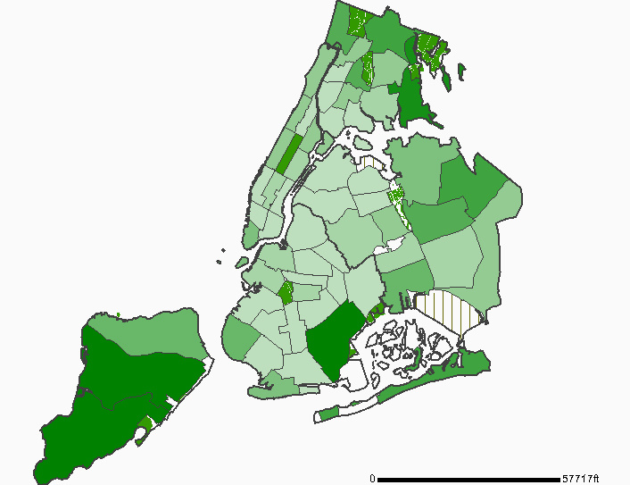
At just .77 acres of open space per 1,000 residents [PDF], CD14 ranks 47th out of 59 Community Districts. Worst off across the whole city is East Flatbush (Brooklyn CD17), with just .11 acres for 1,000 residents.

Generated with NYCHANIS.
Open Space by Community District, NYC

The Web site for the report has a complete index of reports by Community District.

Links:

State of New York City’s Housing and Neighborhoods 2006
The Furman Center for Real Estate and Urban Policy
New York City Housing and Neighborhood Information System (Requires free registration)

News: Creating Wildlife Habitat in Windsor Terrace

In the New York Daily News today:

In the densely populated strip of land between Prospect Park and Green-Wood Cemetery, [Jennifer] Hopkins and fellow gardeners are creating oases of green for butterflies and birds.

The goal of the Greenway Project is to link two of Brooklyn’s largest habitats – at least for airborne species.
Oases of green for butterflies and birds, New York Daily News, June 12

For the birds, Hopkins plants berry bushes, has a cherry tree and keeps her birdbath full. One neighbor has followed in her footsteps and put up a humming bird feeder. Another has a bush where a family of cardinals is nesting. The nearby Immaculate Heart of Mary Catholic Church is also on board and is set to plant a garden this summer, she said.

The article never mentions the name of the neighborhood “between Prospect Park and Green-Wood Cemetery.” It’s Windsor Terrace.

I know of a “Greenway Project” in Brooklyn, but the one mentioned in the article seems to be a different effort. Jennifer, if you read this, please let us know more.

Whatever the name, it’s important to educate and engage private landowners in maintaining and developing wildlife habitat by preserving and planting trees and other non-lawn plants on their properties.

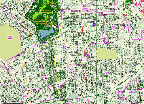
I’ve shown this map on this blog before. It shows the landcover classification for central Brooklyn.
Brooklyn City Council District 40: Classified Landcover

Windsor Terrace forms a corridor between two refuges: Greenwood Cemetery and Prospect Park. Victorian Flatbush forms a corridor extending south from Prospect Park, pointing toward the bays, beaches, and Atlantic Ocean. I recently saw an ovenbird in my backyard, “rare in the city” according to Hopkins as cited in the article.

Most of the tree canopy in Brooklyn is in private hands. It’s unprotected and vulnerable. If New York City is going to have a million more trees in the next ten years, we need to value and find ways to preserve and protect the ones we already have, including those on private property.

Resource: Animated Map of Historical Development

Trulia Hindsight is an animated map of homes in the United States from Trulia. The animations use the year the properties were built to show the growth of streets, neighborhoods and cities over time.

The title of this post links to a map covering most of Victorian Flatbush, as well as Kensington. On that map, the years range from 1800 to the present. I can only find one little blip for the year 1800; you can find it if you pause the animation, then drag the year slider one year at a time. Then the map shows nothing until 1895

Trulia uses publicly available data for the year of development. For NYC, these data are notoriously unreliable for specific properties; for example, it shows our house was built in the 1930s, although we know it was built in the early 1900s, most likely 1900. Nevertheless, the data are reasonably valid for showing trends.

I’ll try to get a good screenshot.

Via OuterB.

Brooklyn Botanic Garden, April 14, 2007

[Updated 2007.04.19 21:30 EDT: Added Fragrance Garden, Magnolia Plaza, Daffodil Hill, and Lily Pool Terrace.]

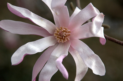
Magnolia Flower, Magnolia Plaza, Brooklyn Botanic Garden
Magnolia Flower

We visited the Brooklyn Botanic Garden last Saturday. So did a lot of other people. It was a perfect day, the day before the Nor’Easter hit and dumped a record rainfall on New York City.

As before, two ways you can explore. The title of this post links to the Flickr set of photos. Or, you can explore the Google Map of my visit.

Google Map of my visit to the Brooklyn Botanic Garden on April 14, 2007

Rock Garden

West Path, South of the Rock Garden Scilla, Rock Garden Tulipa biflora, Rock Garden Narcissus, Rock Garden Stone Basin, Rock Garden Stone Basin, Rock Garden Hellebores and Beyond Signage, Rock Garden Signage, Rock Garden Signage, Rock Garden Legacy Willow outside the Rock Garden John Perambulatin'

Caucasian Wingnut

Best. Name. Ever. For a tree. This may be the most photographed non-flowering tree in the Garden. I’ll honor it with its own post some day.

Caucasian Wingut Shadow of a Wingut Caucasian Wingut (the Tree)

Compost Demonstration Area

Another feature of the Garden deserving of its own post. Just a couple of shots here. Check the Flickr set for all the signage. I liked the homemade styles; either one would work in my garden, now that I have enough space. Yes, I’m a geek.

Compost Demonstration Site Two-Bin System Two-Bin System, Interior View Garden Gourmet Biostack Compost Bench

Native Flora Garden

Entrance to the Native Flora Garden Gate, Native Flora Garden Gate Panel, Native Flora Garden Spider Arboglyphs, American Beech, Native Flora Garden de Vries Sweet Gum, Native Flora Garden Flower, Lindera benzoin, Native Flora Garden Hepatica, Native Flora Garden Skunk Cabbage, Native Flora Garden Confederate Violet, Native Flora Garden

Japanese Garden

I walked the south path of the garden. I don’t remember ever walking this way before. It’s a different perspective. And it’s also where the turtles like to hang out.

Pond, Japanese Garden Cherry Tree, Japanese Garden Pond, Japanese Garden Cherry Tree, Japanese Garden Japanese Garden Sleeping Duck, Japanese Garden Curiosity Salix bockii, Japanese Garden Salix bockii, Japanese Garden Pond, Japanese Garden Red-Eared Slider on Rock, Japanese Garden Pond Overlook, Japanese Garden

Fragrance Garden

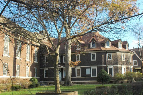
This has the most beautiful stonework in the whole garden. It lies between the Shakespeare Garden and the recently landmarked Laboratory Administration Building which faces Magnolia Plaza.

Fragrance Garden Fragrance Garden Fragrance Garden Fragrance Garden Braille Sign for Chives in the Fragrance Garden Fragrance Garden Gate Sign, Fragrance Garden

Magnolia Plaza

They were at their peak when we visited. They’ll be just passing their peak right now.

Magnolias and Lab Admin Building Magnolia Flowers Urn, Magnolia Plaza Urn, Magnolia Plaza Walkway Compass, Magnolia Plaza Urn, Magnolia Plaza Urn, Magnolia Plaza Magnolia in front of Lab Admin Building Magnolias and Cupola Magnolias in front of Lab Admin Building Magnolia Plaza and Lab Admin Building Lab Admin Building Magnolia Flower Magnolia Flower Armillary Sphere, Magnolia Plaza

Daffodil Hill

Originally known as Boulder Hill, there’s still a marker for the old name.

Daffodil Hill viewed from Magnolia Plaza Plaque, Boulder Hill (Daffodil Hill) Daffodil Hill Daffodil Hill Daffodil Hill Daffodil Hill Daffodil Hill

Lily Pool Terrace

The Annual Borders are about to explode with Tulips. I didn’t get any shots of the Mixed (Shrubs and Perennials) Border, which has year-round interest and is lovely right now. Next trip.

Lily Pool Terrace and Palm House Goldfish and Palm House Darwin Hybrid Tulip "“Garant”" Reflections Kaufmanianna Tulip "“Early Harvest”" Double Early Tulip "“Yellow Baby”"

Related content

Flickr photo set

Map: Brooklyn Coastal Storm Impact Zones

[Updated 2007.04.17 21:40 EDT: Removed bad link in title.]

Brooklyn Category 1-4 Coastal Storm Impact Zones

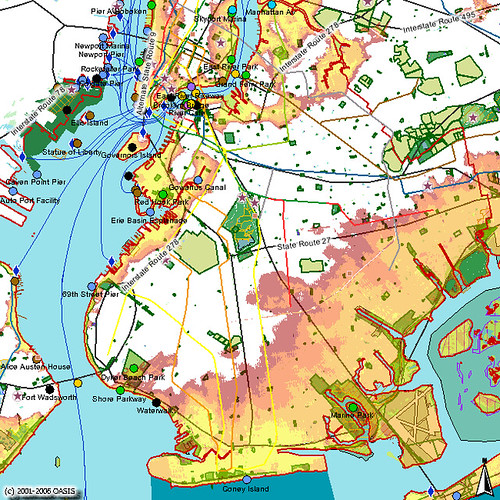
This maps shows Brooklyn impact zones for Category 1 through 4 coastal storms. OASIS recently added this layer to their already invaluable Web mapping service.

You can view the live map, where you can zoom in or out, select different layers and labels, and see how your neighborhood is affected.


A Visit to the Brooklyn Botanic Garden, April 1, 2007

[Updated 2007.04.07 14:30 EDT: Added photos from the Rock Garden.]
[Updated 2007.04.07 11:30 EDT: Began adding photos to this post, and added more photos to the map.]

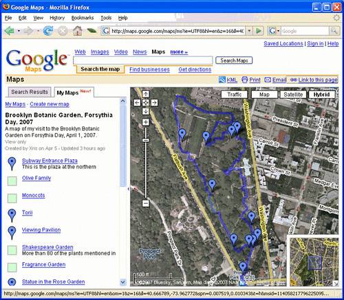
Screenshot of my Google Map of my visit to BBG on Forsythia Day
The post title and the image above are linked to my first attempt at using the new MyMaps feature of Google Maps. Let me know if/how it works for you. Is this annoying? Helpful? Interesting? Too geeky? Too slow?

The path shows the route I took, roughly, through BBG the day of my visit. Most of the areas and placemarks on the map along the way contain photos. The photos in turn are linked to their Flickr pages. You can also just browse the Flickr set of photos from my visit.

Here are some of the photos from my visit.

Forsythia Distribution

Waiting for Forsythia Waiting for Forsythia Opening the Gates Forsythia Line Forsythia Handouts

Forsythia Distribution Center

Rock Garden

I did get to see the Rock Garden as I had planned. I wasn’t disappointed. I don’t usually get to see this garden. It just seems off the beaten path during my usual visits. I want to visit it more often.


Dyer's Broom? Genista tinctoria Rock Garden Flowers, Erica carnea “Springwood Pink”


Rock Garden Rock Garden Leaves, Dyer's Broom Hellebores, Rock Garden Some kind of Willow flowers Corylopsis pauciflora, Buttercup Winterhazel

Other images


Signs of the Day Cornus mas and my doppelganger Andromeda Flowers Brooklyn-Flatbush Boundary Line

Children's Garden Cornus mas flowers Korean Azalea, Rhododendron mucronulatum Andromeda flowers Brooklyn-Flatbush Boundary Marker