Interactive Keys for Woody Plants in New York

In the Spring 2007 edition of their Members News newsletter, the Brooklyn Botanic Garden noted a new Web resource available from the BBG Research department:

BBG scientists have developed interactive identification keys to woody plants of the region …
… Users often experience difficulties naming a plant when the [field] guide refers to a structure (e.g., flowers) that the specimen does not have. If the structure doesn’t exist, the user is stuck at that identification step, with limited options for further classifying the plant.
– Woody Plant Identification Made Easy With Interactive Keys, BBG Members News Newsletter, Spring 2007 (PDF, requires membership login), p. 3

The keys are available for the New York City Metropolitan Area, and for New York State. They’re packaged as ZIP files for download for PCs and PDAs. I downloaded both PC versions to try them out; each file is about 4MB in size. (The PDA versions are huge, over 100MB, for reasons I’ll explain later.)

The PC version comes as a handful of HTML files (Web pages), Javascript files (little chunks of programs and information), and JPEGs (images). I tested using the keys with Internet Explorer 7. You need to enable or allow scripting to use the keys; if the IE Information Bar tells you it “restricted this webpage from running scripts”, you need to “Click here for options..” and select “Allow Blocked Content…”

The main page is a frameset (a Web page with different areas). The left-hand frame, or pane, provides the key. It’s much like a traditional key, a series of yes-or-no questions. However, instead of the traditional hierarchical key, the key is flattened out so that all 106 questions are presented at once. For example, here is their question #34:

34. Leaf (leaflet) apex:
mucronate-cuspidate
otherwise

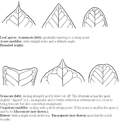
Of course, you still need to know what “mucronate-cuspidate” means. That’s where the images come in. The text for each key links to a JPEG file which provides an example of the key, and sometimes additional text. For example, here’s the image which comes up when you click the “Left (leaflet) apex” label from Key #34:

Leaf apices

The right-hand pane lists plant taxa, either genus or species. Clicking a genus expands to the list of species. For example, Amelanchier expands to:

Each species name links to the details for that plant. This Amelanchier example is from the Metro version of the keys; each name links to its page on BBG’s New York Metropolitan Flora Project (NYMF) Web site. The NY State version takes you to the New York Flora Association Atlas (NYFA) Web site. I’m guessing that the PDA versions of the keys load all these pages onto the PDA instead of linking to the external Web sites, which is why those download files are so large.

The next to each name gives you the keys for that species. Here are the keys for Amelanchier canadensis:

Amelanchier canadensis

Habit: undefined
Habit: not stoloniferous
Leaf development at flowering time: most leaves not fully developed (i.e., folded or in bud)
Underside pubescence in young leaves: densely pubescent
Color of young leaves: undefined
Leaf outline: undefined
Leaf outline: otherwise
Leaf apex: undefined
Leaf base: acuminate, acute, cuneate, obtuse or rounded
Leaf base: undefined
Leaf margin: finely toothed (more than 6 teeth per cm.)
Inflorescence: many flowered (usually more than 5) raceme
Inflorescence: erect or ascending
Inflorescence: axis and pedicels pubescent
Petal length: usually less than 10 mm.
Micropetaly (petals greatly reduced to nearly absent): absent
Ovary summit: glabrous or slightly pubescent and glabrate (i.e., not persistent)

Finally, the top frame/pane has two buttons which allow you to synch up or filter the contents of the left and right panes. After selecting one or more keys in the left pane, clicking the button filters the list in the right pane to matching genera and species. Similarly, after selecting a genus in the right pane, you can click the button to filter the keys to relevant questions to distinguish species within the genus. (This seems to happen automatically when you select a genus anyway, so I’m not sure why this button is needed.) If you know you’re looking at an Oak or a Maple, for example, you could use this feature to identify which species.

I haven’t had a chance to actually use the keys yet to identify anything. But there are some confusing Maples I’ve got my eyes on.

Links:

Gateway National Park Public Design Competition

There is a Public Competition open for envisioning and designing the future of Gateway National Park, also known as the Gateway National Recreation Area. The deadline for registration is next week, February 28, 2007.

Gateway is huge. It covers 10,374 acres of land and 16,233 acres of water, a total of 26,607 acres. For comparison, the entire island of Manhattan is about 12,800 acres. Gateway consists of three “units”: One in New Jersey, and two in New York City. The Jamaica Bay Unit straddles Brooklyn and Queens. It comprises the majority of Gateway: it covers 19,752 acres, 12,367 of which are water, the remainder of which are 15 different parks, beaches, wildlife refuges, and other sites of interest. Over 330 species of birds have been recorded in Jamaica Bay Wildlife Refuge, the largest designated area within the Jamaica Bay Unit.

Even if you don’t intend to compete, there are hundreds of pages of documentation, scores of maps, and innumerable photographs of Gateway available in the Site Brief section of the competition Web site. Although some details are available only to registrants, much of the information is available, intentionally, to the public at large, to help inform public discussion:

Gateway was designated the first urban National Recreation Area on October 27, 1972, exactly one century after Yellowstone became the first national park in the United States and the world. Thirty-five years later, Gateway continues to struggle to meet the aspirations of its founders, to negotiate its relationship with the communities that surround it, and to balance the goals of historic preservation, environmental conservation, and active recreation.

Gateway presents a significant regional resource with incredible infrastructural, ecological and cultural value in the New York metropolitan region, hosting endangered birds, fish and shellfish breeding grounds, marinas, playfields, and cultural relics. It is also the site of combined sewer outfalls, treated wastewater effluent, abandoned buildings, degraded habitat, drowned marshes, former landfills and vast asphalt runways.

Both the complexity of Gateway and the scope of this design competition call for an immense amount of background information about the park. The materials provided throughout the Site Brief area of the website are taken from a Research Report prepared by a team of investigators from Columbia University’s Graduate School of Architecture, Planning and Preservation. The report is comprised of written chapters, extensive mappings, external primary sources and site photographs. It is intended to provide a comprehensive overview of the conflicting issues facing Gateway historically and today.

We are pleased to make the majority of this information available to both competitors and the public-at-large. The Research Report can be downloaded in its entirety for the duration of the competition, and selected images and mappings are available for public browsing throughout this section of the website.

Links:

Grief & Gardening #2: Five Years After, “Ths Transetorey Life”

There are three sections to this post:

  1. Trinity
  2. Ground Zero
  3. St. Paul’s

Trinity

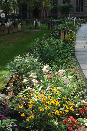
This is a flower border at one of my favorite gardens to visit. Earlier in the year, there has been a succession of Iris, Hemerocallis (Daylilies), Hosta, and other common and sturdy garden perennials. There are ferns, and flowering cherry trees on the grounds.
Flower Border
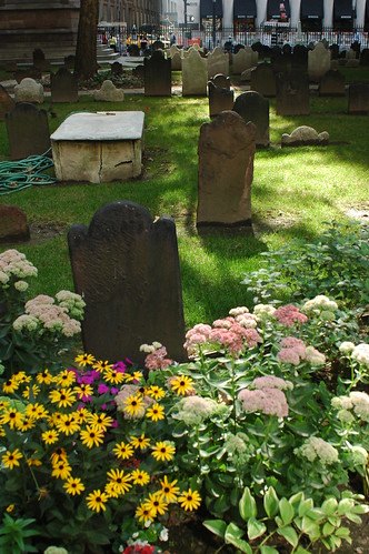
The garden is the cemetery at Trinity Church in downtown Manhattan, just down the block from Ground Zero. The photo above is looking south, toward the church itself. Here’s another view looking east, toward Broadway, which is just on the other side of the wrought iron fence surrounding the cemetery.

Flowers, Trinity Church Cemetery
This really is one of my favorite gardens to visit. First off, I love cemeteries. During my troubled adolescence, a cemetery at the end of our street was a refuge for me, a place I could go where no one would bother me, a place of solitude, and quiet. I came to enjoy the history of it, reading the stones to learn about people’s lives, how young they died, how many of them were children, and infants.

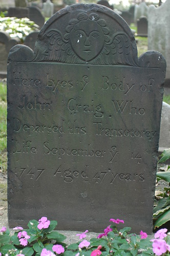
This garden cemetery also reminds me of impermanence. When I walk through it, I’m on my way to work, in the financial district of downtown Manhattan. It’s easy to get stressed about work. This walk helps me keep a healthier perspective on things. Check out the engraving on this headstone.

Headstone, Trinity Church Cemetery
“Here Lyes ye Body of John Craig Who Departed ths Transetorey Life September ye 14 1747 Aged 47 years” At 47 years, he was an old man when he died. He could have easily been a grandfather. And yet, “ths Transetorey Life” … Next week is the 259th anniversary of his death. How many lifetimes, how many generations, is 259 years?

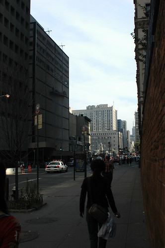
Another thing I enjoy about visiting this garden cemetery is the ritual I’ve developed for entering it. There’s really only one way: from the Rector Street station on the R/W subway line. This lets me out on Church Street. After emerging from the subway, the streetscape is the photo below.
Church Street, looking North toward Ground Zero
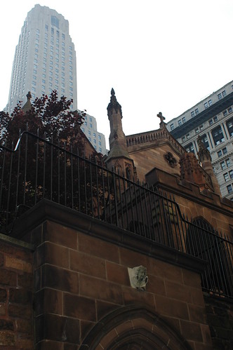
This is Church Street, looking north. Ground Zero (of which more below) is just one block away, where the buildings end on the left-hand side. On the right-hand side is a massive, and seemingly ancient, sandstone block wall. See the trees peeking out over the top of it? Those are from the garden cemetery. Here’s a view of the church from this vantage.
Trinity Church
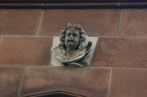
That’s right: the cemetery is two stories above your head. Behind those stone blocks are the dead. To reach the cemetery, we have to climb still further, through the street-level opening in the wall, of which we only see the top of its gothic arch in the photo above, and up another two flights of stairs. Lest one forget, the sculpture set in the stone above the passageway is no cherub.
Grieving Angel

Ground Zero

I wrote earlier this week about the arbitrariness of anniversaries. But I have been feeling this one, the 5th anniversary of 9/11. The city is feeling it, too. Peoples’ grief is closer to the surface, more accessible. Mine certainly is. I’ve also been remembering a lot of what it was like in the city right after. There are reminders of it everywhere, on the news, in the papers, special exhibits and events, and especially, at Ground Zero.

A Tribute Center was dedicated this week on Liberty Street, on the south side of Ground Zero. I’d heard about it and I went there after work on Thursday. The doors had signs on them which said “Closed.” There was a couple next to me also looking at the signs. Someone inside saw them and opened the door for them. I thought they were just closing for the day, and let us in anyway. I tailgated in. I didn’t realize that it’s not open to the public until September 18.

Anyway, it’s quite a collection. They have artifacts. It took me a while to figure out what this object was. When I did, it just shocked me. I didn’t have my camera with me, just my camera-phone/phonecam. It’s a lousy picture, and I’ll go back and get a better one.

Another thing which shook me was some photographs in one of the display cases. There was a contact print of a couple of frames from a still camera, with some clear problems with light leakage along the top of the frame. The text explained that these photographs were taken by a photographer on the scene. His camera was damaged, and he was killed, when the first tower fell. His camera and film were recovered, and those prints were made.

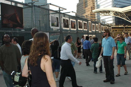
Outside the PATH (Light rail/Subway to New Jersey) station, on the fence surrounding the site, is an exhibit of photographs from September 11 and the recovery efforts. The photographs are incredible, from all different photographers.
DSC_1696

The names of the photographers and explanations of each scene are displayed alongside the photos. I didn’t make notes of their names. I’m hoping I can find a catalog of them online somewhere. Here’s one of the photographs.

St. Paul’s

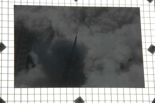
St. Paul's Enshrouded
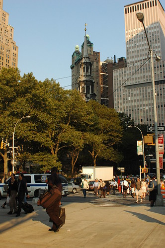
This shows the tower of St. Paul’s Church about to be engulfed by the debris cloud from the collapse of the first tower. I’m pretty sure this was taken from an office building to the east, looking west toward the church and the World Trade Center site. St. Paul’s is directly across the street from the PATH station, and just a couple of blocks up the street from Trinity Church.
St. Paul's Church, viewed from the PATH Station
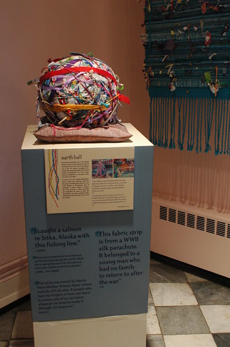
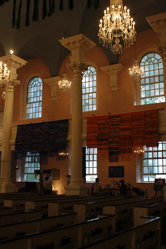
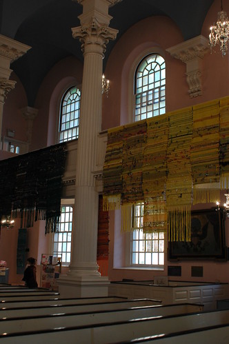
St. Paul’s sustained heavy damage, but it survived, and it served as one of the centers for recovery efforts downtown. Its fence was covered with memorials for months. Right now it’s housing the Threads Project, which collected threads, ribbons, and so on from all over the world and distributed it to weavers all over the world to create the works you see below.

St. Paul's Church, Interior, South Wall
St. Paul's Church, Interior, North Wall

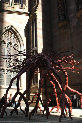
One of the losses at St. Paul’s was a large Sycamore from the cemetery. If the tree had not been there, the church would have sustained even greater damage from debris which felled the tree instead. The tree has been captured as a symbol of the day, by casting its root system as a sculpture in bronze. This sculpture is permanently placed in a courtyard outside Trinity Church. The sculpture is called “Trinity Root.”
Trinity Root

And so we’ve come full circle. From Trinity, to Ground Zero, to St. Paul’s, and back again. We grieve the loss of a great tree, whose death saved others’ lives, and celebrate it. We grieve the garden, and grieve through the garden. It’s the weekend before five years after. I will be mowing the lawn, weeding, maybe sifting some compost, and preparing the garden to receive the bulbs which should arrive in a few weeks. I will do all these ordinary things. And when I return to work on Monday, I will look up, and turn my face to the hole in the sky, and remember again.

Related content

Flickr photo set
Grief & Gardening series

News, August 1, 2006: NASA Earth Observatory Maps NYC’s Heat Island, Block by Block

Timely enough, given the record temperatures we’re experiencing this week. Tomorrow’s forecast has been “upgraded” from what I reported yesterday: the THI may reach 117F tomorrow.

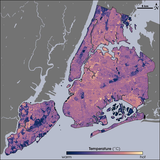
Temperatures in New York City as measured by Landsat on August 14, 2002, at 10:30am, during a heat wave. Cooler temperatures are blue, hotter are yellow.
Source: NASA Earth Observatory. Map by Robert Simmon, using data from the Landsat Program.
NASA Map of Surface Temperatures in New York City, 2002-08-14

Temperatures in New York City as measured by Landsat on August 14, 2002, at 10:30am, during a heat wave. Cooler temperatures are blue, hotter are yellow.
Source: NASA Earth Observatory. Map by Robert Simmon, using data from the Landsat Program.
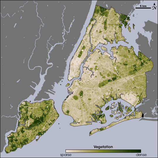
NASA Map of Surface Vegetation in New York City

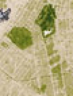
The ability of vegetation to moderate urban temperatures is graphically demonstrated in these paired images from NASA’s Earth Observatory. The spatial resolution of these images is 60 meters per pixel. At that scale, I can just about make out the block where I garden:

Closeup of the vegetation map, centered on central Brooklyn. The green area at the left is Greenwood Cemetery. Prospect Park is the dark green area at the top; the white area within it is Prospect Lake.

Below the park, to the south, Victorian Flatbush, with its tree-lined streets, detached wood frame houses, and front lawns, spreads out as a series of olive green areas. The beige areas in-between the olive are rowhouses and apartment buildings. You can even make out a curving green line across the southern end of this area: That’s the old LIRR right-of-way, long abandoned, and overgrown with trees.

NASA has just published a report on urban heat islands highlighting the research of Stuart Gaffin, an associate research scientist with the Earth Institute at Columbia University in New York City, and his colleagues:

In the summer of 2002, Gaffin and his colleagues used satellite temperature data, city-wide land cover maps, and weather data, along with a regional climate model to identify the best strategies for cooling the city. The team estimated how much cooling the city could achieve by planting trees, replacing dark surfaces with lighter ones, and installing vegetation-covered “green roofs.”
The team studied the city as a whole, as well as six “hotspot” areas—including parts of Manhattan, the Bronx, Queens, and Brooklyn—where air temperatures near the ground were higher than the city-wide average. Each area was serviced by Con Edison, the local power company, so the scientists could compare electricity use. Each area also had available space so that the mitigation strategies the team considered could be modeled in the study and potentially implemented later on.
August 14 fell on one of the hottest heat wave days in New York’s summer of 2002, making it a good day to take the city’s temperature. Measuring the temperature of every last sidewalk, street, parking lot, roof, garden, and grassy area in an entire city isn’t easily done from the ground, so the researchers relied on NASA to take the city’s temperature from the sky. NASA’s Landsat Enhanced Thematic Mapper collected thermal infrared satellite data. …
Beating the Heat in the World’s Big Cities

Related posts

Urban Forestry

Web Resource: New York Metropolitan Flora Project (NYMF)

Updated, 2013-08-25: Corrected links.


Brooklyn Botanic Garden‘s New York Metropolitan Flora Project (NYMF) documents the distribution of woody plant species among 25 counties in New York, New Jersey, and Connecticut within a 50-mile radius around New York City. Tools available online include:

While most of the botanical community concentrates on tracking the threats to biodiversity in the tropics, scientists at the Brooklyn Botanic Garden are undertaking the most comprehensive study ever of the plant biodiversity in metropolitan New York. Studying the vegetation changes in highly populated areas is critical to understanding the future of life in our rapidly urbanizing world. …
Understanding the urban landscape is critical in our rapidly urbanizing world. Findings of BBG’s Metropolitan Flora Project serve as vital references for those involved in environmental efforts, from preserving rare plants, to planning parks and greenways, to repairing degraded habitats, to designing home gardens in which native plant communities are preserved or restored.

Links

Brooklyn Botanic Garden: New York Metropolitan Flora Project

Article, Fall 2005: The Changing Flora of the New York Metropolitan Region

The authors compare past distribution data from historical records, and current data from Brooklyn Botanic Garden’s New York Metropolitan Flora Project to determine changes in distribution over the past century. They further compare these changes between native and introduced species within the same genus, such as Celastrus scandens, American bittersweet (native) and Celastrus orbiculata (or C. orbiculata), Oriental bittersweet (introduced, and invasive), or Lonicera sempervirens, Trumpet honeysuckle (native) and Lonicera japonica, Japanese honeysuckle (introduced, and invasive).

We statistically analyzed 100 years of herbarium specimen data for woody plants in the New York metropolitan region in order to measure the floristic changes of this area. Change Index values were computed for 224 of the region’s 556 woody species to provide a specific measure of whether these species are expanding, contracting, or stable. The results show that, in general, nonnative invasive species are spreading rapidly in the region, while native species are in slight decline.
The Changing Flora of the New York Metropolitan Region

Links

The Changing Flora of the New York Metropolitan Region, Urban Habitats, Volume 3, Number 1, Fall 2005, Brooklyn Botanic Garden, 1000 Washington Avenue, Brooklyn, NY 11225