New York Magazine: How Much Is a Street Tree Really Worth?

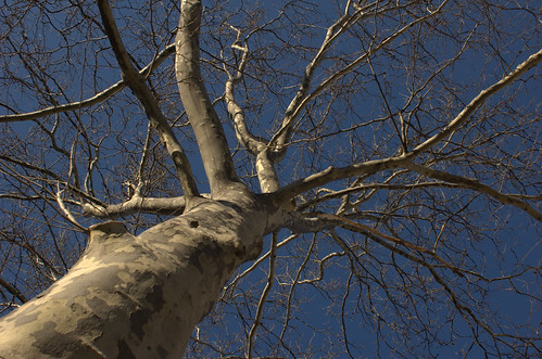
The London Plane Tree in front of our house. It’s taller than the house, and provides shade in the summer and fall.
Sycamore Maple? Street Tree, Stratford Road

Over the last two summers, more than a thousand people volunteered to conduct a tree census of the five boroughs, the second in the city’s history (the other was in 1995) — and the first to put a price tag on each specimen.

… Each tree’s type, age, size, and location was fed into a computer program, developed by the U.S. Forest Service and the University of California, Davis, that quantified the plant’s annual value in saving energy costs (more shade means less air-conditioning), improving air quality, absorbing storm-water runoff, and prettifying the block. The study determined that street trees are collectively worth $122 million a year to the city, with an average of $50 to $300 apiece.

How much is a street tree really worth?

Not surprisingly, the oldest and largest are worth the most. … The standard formula says a dwelling with a tree in front is worth .88 percent more than a home without one … The city’s math allowed for a tree’s effect on property values, but with a limitation: The survey priced all houses equally, at $537,300, the median cost of a single-family home in 2005.

The article goes on to profile the value to the city and the homeowner of four different street trees in four different settings. Based on its age, and the real estate prices in our neighborhood, I’m estimating our street tree is worth $300-400 a year to the city, and adds about $10,000 to our property value.

via New York Observer

Event, April 15, Bronx: Bartow-Pell’s Preservation of its Orangerie Doors

This is the first I’ve heard of the Bartow-Pell Mansion Museum. I’m not generally one for musty old rooms. The Orangery looks lovely. And there are some formal gardens to sweeten the visit.

On Sunday, April 15th at 4pm, Curtis Barnhart and Nate Shellkopf will provide a hands-on presentation about the techniques used and the intricacies of restoring Bartow-Pell’s L’Orangerie doors. They will also discuss the importance of preserving historic structures in an age when older structures are often taken down and replaced by new building. The fee is $8/pp. Please call 718-885-1461 or email info@bpmm.org to make a reservation.

The Bartow-Pell home was built by Pell descendent, Robert Bartow, between 1836 and 1842. The property was annexed by the City of New York in the late 1880s and was then left in derelict condition. In 1914, the women of the International Garden Club saved and restored the site and opened the gates to the public as a museum in 1946.

During the years of 1915-1918, the firm Delano and Aldrich undertook the restoration of the Bartow-Pell Mansion Museum and were credited with the creation of a new conservatory, otherwise known as L’Orangerie. After years of wear and tear; and witness to almost 100 years of history, the doors were in desperate need of repair. In the summer of 2006, the restoration and preservation of beautiful doors went underway. Curtis Barnhart of Barnhart Restoration and Nate Shellkopf of Southslope Woodworks were charged with the challenge of conserving the existing deteriorating wood, priming and painting of the word work. They also cleaned and conserved the door and transom hardware. At the end of the summer the team provided the Bartow-Pell Mansion Museum with a beautifully repaired L’Orangerie.

Links:

News: Border Collies to Herd Canada Geese in Central Park

I got to watch some sheepdog trials at the New York State Sheep & Wool Festival last Fall. It would be cool to watch them in action in Central Park. And there’s always Sheep Meadow in Prospect Park!

This April, the Central Park Conservancy and the New York City Department of Parks & Recreation will pilot a one-month program using an environmentally-safe method to attempt to reduce the number of geese in Central Park. The first step of the process includes herding- but never touching or attacking- the geese with highly-trained border collies. Skilled trainers will lead two border collies in driving the geese away from the Park’s lawns and water bodies throughout the month of April. Parks Department Rangers and Central Park Conservancy staffers will supervise training and goose management.

Large flocks of resident Canada geese leave excessive goose droppings, resulting in large areas of landscape that are unavailable for public use and recreation. In Central Park, geese continually overgraze the grass around the Harlem Meer and its surrounding landscapes, increasing erosion. The high nitrogen content in goose droppings can alter water chemistry and produce algae that rob the water of oxygen, killing fish and other wildlife.

Bred to herd sheep, collies have a natural instinct to round up flocks of geese. By patrolling various areas of the Park, the geese will be encouraged to abandon the lawns and water. In conjunction with the border collies, public education is crucial. Feeding geese only encourages them to linger in public areas. Herding dogs and education are two methods of Canada goose management that are approved by the Humane Society and the USDA Office of Wildlife Services.

To deem its effectiveness in Central Park, Geese Police Inc. will pilot a month-long, 24-hour-a- day program. At the end of the month, the Central Park Conservancy and the Parks Department will determine its effectiveness in moving the geese and interacting with the public before extending the project.

Links:

Happy National Invasive Weeds Awareness Week

It’s a day for news. I don’t know how I missed this, but February 25 through March 2 is National Invasive Weeds Awareness Week. The NYC Department of Parks and Recreation issued a press release Monday:

During National Invasive Weeds Awareness Week, the Department of Parks & Recreation reminds all New Yorkers not to plant invasive weeds, which are threats to New York City’s parks and green spaces. … Invasive species are sold in the City and are commonly added as ornamental interest to landscapes and gardens. …

… Over an extended period of time, an invasive species planted in a home garden has the ability to spread to other natural areas, degrade land, and disrupt natural habitat. Unlike native plants, invasive weeds have no natural predators in non-native natural environments, which allows their population to grow unchecked. One invasive species is the Japanese Barberry (some varieties), which is commonly planted in gardens for its pale yellow flowers and bright red berries but which pose a severe ecological threat in natural habitats by altering soil pH, nitrogen levels, and biological activity in the soil, thus reducing wildlife habitat. Another invasive weed is the Purple Loosetrife, commonly planted for it’s beautiful purple flowers but which outcompetes and replaces native grasses and flowering plants in wetlands areas, thus forming a dense, homogenous clump and reducing habitat for waterfowl.

Invasive weeds have plagued New York City’s natural environment for centuries, arriving with the first migration of Europeans to the continent and currently transported through trade and commerce. Invasive weeds that thrive in the New York City are able do so because the City’s climate is similar to that of their country of origin. Many common invasive weeds in New York City hail from Korea, Japan, and parts of China, where average temperature, amount of rainfall, and rainfall distribution is similar to that of New York City.

Gardeners should check out the Parks Department’s Do Not Plant list of species invasive in the New York City area.

Links:

Gateway National Park Public Design Competition

There is a Public Competition open for envisioning and designing the future of Gateway National Park, also known as the Gateway National Recreation Area. The deadline for registration is next week, February 28, 2007.

Gateway is huge. It covers 10,374 acres of land and 16,233 acres of water, a total of 26,607 acres. For comparison, the entire island of Manhattan is about 12,800 acres. Gateway consists of three “units”: One in New Jersey, and two in New York City. The Jamaica Bay Unit straddles Brooklyn and Queens. It comprises the majority of Gateway: it covers 19,752 acres, 12,367 of which are water, the remainder of which are 15 different parks, beaches, wildlife refuges, and other sites of interest. Over 330 species of birds have been recorded in Jamaica Bay Wildlife Refuge, the largest designated area within the Jamaica Bay Unit.

Even if you don’t intend to compete, there are hundreds of pages of documentation, scores of maps, and innumerable photographs of Gateway available in the Site Brief section of the competition Web site. Although some details are available only to registrants, much of the information is available, intentionally, to the public at large, to help inform public discussion:

Gateway was designated the first urban National Recreation Area on October 27, 1972, exactly one century after Yellowstone became the first national park in the United States and the world. Thirty-five years later, Gateway continues to struggle to meet the aspirations of its founders, to negotiate its relationship with the communities that surround it, and to balance the goals of historic preservation, environmental conservation, and active recreation.

Gateway presents a significant regional resource with incredible infrastructural, ecological and cultural value in the New York metropolitan region, hosting endangered birds, fish and shellfish breeding grounds, marinas, playfields, and cultural relics. It is also the site of combined sewer outfalls, treated wastewater effluent, abandoned buildings, degraded habitat, drowned marshes, former landfills and vast asphalt runways.

Both the complexity of Gateway and the scope of this design competition call for an immense amount of background information about the park. The materials provided throughout the Site Brief area of the website are taken from a Research Report prepared by a team of investigators from Columbia University’s Graduate School of Architecture, Planning and Preservation. The report is comprised of written chapters, extensive mappings, external primary sources and site photographs. It is intended to provide a comprehensive overview of the conflicting issues facing Gateway historically and today.

We are pleased to make the majority of this information available to both competitors and the public-at-large. The Research Report can be downloaded in its entirety for the duration of the competition, and selected images and mappings are available for public browsing throughout this section of the website.

Links:

“Mulch Ado About Nothing”

Christmas Tree, 2006Mulchfest 2007 is on this weekend at locations all around NYC. During this annual event, Christmas trees are shredded into mulch for use in the city’s parks.

NYC residents can drop off their trees at any of the locations. Trees must be free of any decorations: ornaments, lights, tinsel, and so on. At designated “chipping” sites, bring a sturdy bag and shovel and you can trade your tree for mulch. One of these sites is in Prospect Park, at 3rd Street and Prospect park West. Trees can also be left curbside for pickup.

(Don’t blame me for the title of this post. It’s a quote from Mayor Bloomberg.)

News, August 1, 2006: NASA Earth Observatory Maps NYC’s Heat Island, Block by Block

Timely enough, given the record temperatures we’re experiencing this week. Tomorrow’s forecast has been “upgraded” from what I reported yesterday: the THI may reach 117F tomorrow.

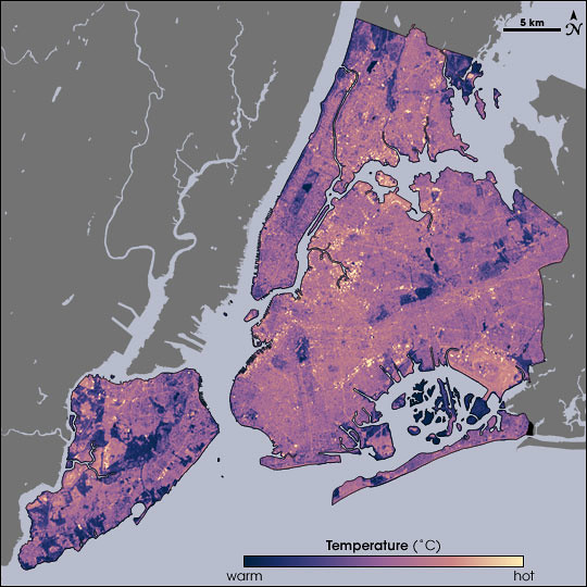
Temperatures in New York City as measured by Landsat on August 14, 2002, at 10:30am, during a heat wave. Cooler temperatures are blue, hotter are yellow.
Source: NASA Earth Observatory. Map by Robert Simmon, using data from the Landsat Program.
NASA Map of Surface Temperatures in New York City, 2002-08-14

Temperatures in New York City as measured by Landsat on August 14, 2002, at 10:30am, during a heat wave. Cooler temperatures are blue, hotter are yellow.
Source: NASA Earth Observatory. Map by Robert Simmon, using data from the Landsat Program.
NASA Map of Surface Vegetation in New York City

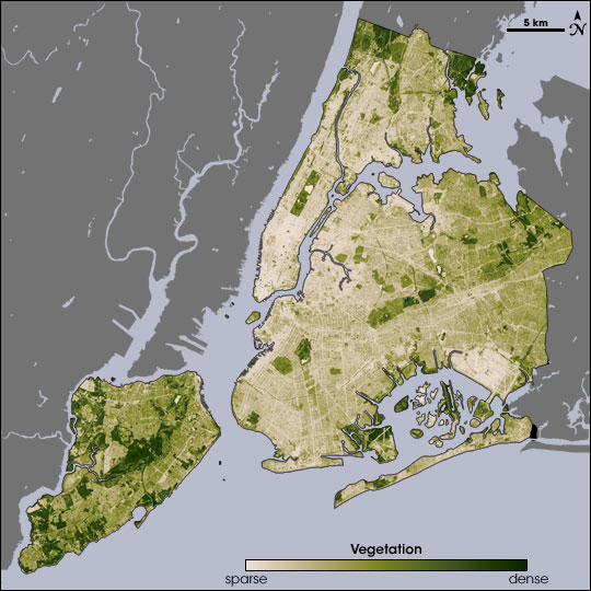
The ability of vegetation to moderate urban temperatures is graphically demonstrated in these paired images from NASA’s Earth Observatory. The spatial resolution of these images is 60 meters per pixel. At that scale, I can just about make out the block where I garden:

Closeup of the vegetation map, centered on central Brooklyn. The green area at the left is Greenwood Cemetery. Prospect Park is the dark green area at the top; the white area within it is Prospect Lake.
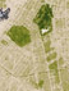
Below the park, to the south, Victorian Flatbush, with its tree-lined streets, detached wood frame houses, and front lawns, spreads out as a series of olive green areas. The beige areas in-between the olive are rowhouses and apartment buildings. You can even make out a curving green line across the southern end of this area: That’s the old LIRR right-of-way, long abandoned, and overgrown with trees.

NASA has just published a report on urban heat islands highlighting the research of Stuart Gaffin, an associate research scientist with the Earth Institute at Columbia University in New York City, and his colleagues:

In the summer of 2002, Gaffin and his colleagues used satellite temperature data, city-wide land cover maps, and weather data, along with a regional climate model to identify the best strategies for cooling the city. The team estimated how much cooling the city could achieve by planting trees, replacing dark surfaces with lighter ones, and installing vegetation-covered “green roofs.”
The team studied the city as a whole, as well as six “hotspot” areas—including parts of Manhattan, the Bronx, Queens, and Brooklyn—where air temperatures near the ground were higher than the city-wide average. Each area was serviced by Con Edison, the local power company, so the scientists could compare electricity use. Each area also had available space so that the mitigation strategies the team considered could be modeled in the study and potentially implemented later on.
August 14 fell on one of the hottest heat wave days in New York’s summer of 2002, making it a good day to take the city’s temperature. Measuring the temperature of every last sidewalk, street, parking lot, roof, garden, and grassy area in an entire city isn’t easily done from the ground, so the researchers relied on NASA to take the city’s temperature from the sky. NASA’s Landsat Enhanced Thematic Mapper collected thermal infrared satellite data. …
Beating the Heat in the World’s Big Cities

Related posts

Urban Forestry