Governor’s Island: What Might Have Been

Governor’s Island, Detail, 1911 New York Dock Dock Company Lithograph
Governor's Island
When we bought our house about three years ago, one of the attractions was “old house romance.” The previous owner believed the house had been in her family since it was built in 1900. I’ve written previously about finding a 1911 lithograph of the New York Dock Company in the basement. Earlier this week, Peter Miller, the new owner of Freebird books in Columbia Waterfront/Red Hook, contacted me by email asking for permission to use one of my photos of it:

Anyone living in the neighborhood, particularly Red Hook, will be familiar with the New York Dock Company’s remnants–hulking gray warehouses that must make Dumbo-drooling Corcoran agents weak in the knees. Seldom however do we get a chance to see a bird’s eye view of their domain, which once sprawled over two and a half miles of waterfront. The lithograph provides a rare peek at the commerce that transpired along the banks of Governors Island and Brooklyn.
– December 28, 2007, Peter Miller, Freebird Books

Miller goes on to write more about the history of Governor’s Island, and how it was nearly lost to infrastructure development.

In 1898 (the year Brooklyn became a borough of New York City), an assemblyman proposed using the island as a center span anchor for a bridge between Red Hook and the Battery. Proof that real estate value has never been far from New York’s beating heart, the assemblyman argued that the bridge “would cause a phenomenal development in South Brooklyn.”

That cheap promise would be reprised forty years later when Robert Moses demanded the very same public works project–but on a far grander scale. Given wide-ranging powers by La Guardia in 1938, Moses tried to reallocate the money meant for a tunnel to build a monumental (in all senses of the word) bridge that would hopscotch across Governors Island.

Today we have this view from Valentino Pier of both Governor’s Island and Downtown Manhattan.
Governor's Island, Downtown Manhattan, and ATF Pier
This view was saved, in part, by opposition from community leaders in both Manhattan and Brooklyn, and, in part, by none other than Eleanor Roosevelt:

Moses’s threats and ultimatums cowed city and state officials into submission. All he needed was the federal government’s rubber stamp. But, unforeseen, Eleanor Roosevelt publicly questioned the bridge’s impact: “Isn’t there room for some consideration of the preservation of the few beautiful spots that still remain to us on an overcrowded island?” The bridge’s opponents had infiltrated the White House. FDR allowed the War Department to kill the project and favor a tunnel out of national security concerns (but more likely out of spite).

Related Posts

1911 New York Dock Company Lithograph

Links

Freebird Books, 123 Columbia Street (GMAP), Brooklyn, New York 11231

Good Place for a Haunting Landmarked

2274 Church Avenue, Flatbush, Brooklyn
2274 Church Avenue

Remember me? I’m now a landmark:

A former public school in Flatbush has been approved for designation as an individual landmark by the Landmarks Preservation Commission. At its meeting on Tuesday, Nov. 20, the commission voted 8-0-0 to approve a recommendation by its research department to designate the former Flatbush District No. 1 School, later named PS 90, at the corner of Church and Bedford avenues and adjacent to Erasmus Hall High School.
Landmarks Commission Designates Former PS 90 in Flatbush, Linda Collins, Brooklyn Eagle, 11/26/2007

Given the condition it’s in, I hope this action hasn’t come too late to save this building. I bet this would make a terrific community center in an area that’s sorely lacking public meeting space.

Related Posts

Good Place for a Haunting, October 27

Links

[where: 2274 Church Avenue, Brooklyn, NY]

Good Place for a Haunting

Update, 2007.11.27: The Landmarks Preservation Commission unanimously designated this building an individual landmark at their meeting on November 20.


2274 Church Avenue, former Public School 90
2274 Church Avenue

With all the big, spooky houses around here, you’d think it would be easy to find something to contribute to the Brooklyn bloggers’ Halloween haunted house meme. Here’s one from me.

According to the Department of Buildings Building Information System (BIS), this magnificent ruin at the corner of Church and Bedford Avenues has a range of addresses assigned to it: 2192-2210 Bedford Avenue, and 2274-2286 Church Avenue. The nominal address for their records is 2274 Church Avenue. The earliest DOB records date back to 1903.

It’s next to Erasmus Hall High School on the Bedford Avenue side. The Department of Finance classification is W-8, an educational structure. The DOB listing also notes that it’s calendared for landmark status. I found it as Item for a September 18 LPC meeting [PDF], which solves part of the mystery: it was a public school:

FORMER PUBLIC SCHOOL 90, 2274 Church Avenue aka 2274-2286 Church
Avenue, 2192-2210 Bedford Avenue, Brooklyn.
Landmark Site: Borough of Brooklyn Tax Map Block 5103, Lot 58

I can’t find anything about what happened at that meeting, or anything else about its landmark status. I can’t find anything about its use as a public school. Everything here is what I found from public records. Anyone know anything more about this?


2274 Church Avenue

2274 Church Avenue

2274 Church Avenue

2274 Church Avenue

2274 Church Avenue

2274 Church Avenue

Related Posts

Good Place for a Haunting Landmarked, November 27
[where: 2274 Church Avenue, Brooklyn, NY]

Beneath New York: The Marine Grill Murals

Marine Grill Murals (1/6), depicting Native Americans in canoes rowing out to greet a schooner.
Marine Grill Murals (1/6), Broadway-Nassau Subway Station

A: They’re rat-infested, crowded, dirty, smelly, and noisy enough to deafen a banshee. However, they are safer than they used to be. And they have magnificent tilework from the golden age of public transportation.
Q: What are the subways?

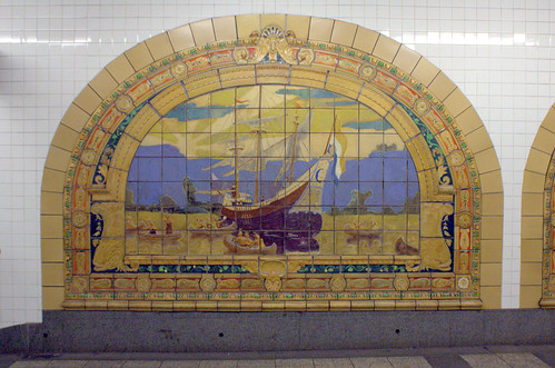
I work in downtown Manhattan. I remember when these tile murals were installed in the Broadway-Nassau Subway Station, astonished when they were revealed. These murals are unusual, even for the subway: they were not originally designed for or located in the subway. They’re also an object lesson in preservation: they were almost lost forever to residential conversion:

The 1913 Marine Grill murals by Fred Dana Marsh, now installed in the Fulton/Broadway/Nassau complex, were originally in a basement restaurant of the McAlpin Hotel on Herald Square. The developer converting the hotel to condos agreed at the last minute to preserve them. While the workers managed to remove most of the ceramic tiles without breaking them, they simply piled them at random in two dozen crates. MTA Arts for Transit had the crates delivered to a TA bus garage with some free floorspace, and a group of college interns spent their summer playing jigsaw puzzle! They were reinstalled at Broadway/Nassau in 2000.
Artwork: Marine Grill Murals, 1913, www.nycsubway.org

Marine Grill Murals (2/6), depicting pilgrims arriving at a Dutch settlement on the shore, complete with windmill and hangings.
Marine Grill Murals (2/6), Broadway-Nassau Subway Station

A 1990 article from the New York Times provides more background:

A collection of colorful terra cotta wall panels designed by the late muralist Fred Dana Marsh that depict New York City’s nautical heritage is looking for a new home. For over 40 years the 24 panels were the backdrop for the 250-seat Marine Grill at the McAlpin Hotel on Herald Square, which opened in 1912 and between World Wars was one of the city’s more fashionable restaurants.

Preservationists failed in a bid to have the restaurant designated by the Landmarks Preservation Commission but the wall tiles may be saved if a museum or historically oriented group can use them at a new location.

POSTING: From the McAlpin; Nautical Tiles, Anyone?, By Richard D. Lyons, Published: January 21, 1990

Marine Grill Murals (3/6), appears to depict a British Man-o-War firing cannons in New York Harbor.
Marine Grill Murals (3/6), Broadway-Nassau Station

A 2001 article, also from the Times, follows up after the murals were installed in the subway:

It would have been hard for Susan Tunick, president of the Friends of Terra Cotta, to imagine a happy ending a decade ago [ie: 1991 or so, shortly after the above NY Times article was written] when she saw dumpsters at the McAlpin Hotel on Herald Square filled with fragments from the fabulously ornate Marine Grill murals of 1912 by Fred Dana Marsh. “It was truly devastating,” she recalled. “I could not go near it.”

That is not where the story ended, however. A rescue effort began that eventually involved the New York Landmarks Conservancy, the Municipal Art Society, the Landmarks Preservation Commission and the Metropolitan Transportation Authority.

Students working under Vel Riberto of the M.T.A. Arts for Transit program reassembled the jumbled pieces, which were turned over for conservation to the Alan M. Farancz Painting Conservation Studio and then reinstalled by New York City Transit workers as part of the overall renovation of the station.

“Something about this terra cotta brought out the best every person had to offer,” said Sandra Bloodworth, director of Arts for Transit. “It was the opportunity to put Humpty Dumpty back together again.” The project cost about $200,000.

POSTINGS: Rescued McAlpin Hotel Murals From 1912 Find a Home in the Subway; For Terra Cotta, Terra Firma, By David W. Dunlap, Published: April 29, 2001

Marine Grill Murals (4/6), depicting Robert Fulton’s steamboat Clermont (1808).
Marine Grill Murals (4/6), Broadway-Nassau Subway Station

Marine Grill Murals (5/6), depicting the Mauretania (1906).
Marine Grill Murals (5/6), Broadway-Nassau Subway Station

Marine Grill Murals (6/6), depicting the Fall River Line steamboat COMMONWEALTH in 1908.
Marine Grill Murals (6/6), Broadway-Nassau Subway Station

It’s also nice to see these murals show up in a visualization of the redesigned Fulton Street Transit Center, the construction of which has been disrupting traffic above and below ground for the past two years:

Fulton Street Transit Center: A view east to the A/C mezzanine, which will improve connections to the J/M/Z platforms. Credit: LowerManhattan.info. Source.
Marine Grill Murals in the Fulton Street Transit Center

I found some more information, including descriptions of what’s depicted in each mural, in This Week in New York. This helped me make out as best I can what’s depicted in each mural:

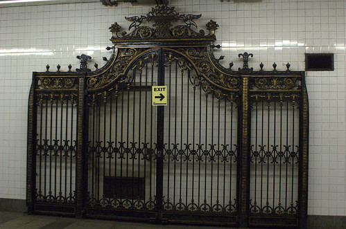
The landmarked terra-cotta murals, designed by Fred Dana Marsh, reveal the history of New York harbor, making their 2000 move to this downtown station near the water rather sensible. The murals depict Native Americans rowing out in canoes to greet a large schooner, pilgrims landing on the shore (look for the Dutch windmill and the two people being hanged), Robert Fulton’s Clermont steamer, a luxury liner sailing in front of the more modern New York City skyline, and lots of other ships bearing a multitude of international flags. In addition to the murals (of which there were originally twenty at the McAlpin), the intricately carved ironwork entrance gate to the restaurant is on display as well.
Exposed bodies and marine murals at the Seaport [Note: Skip past the gruesome photos preserved Chinese prisoners bodies from the Bodies exhibit.]

Ironwork gate from the Marine Grill Restaurant, Broadway-Nassau Subway Station

I can find little information about the artist. Although a Google search turns up hundreds of hits, most of them simply duplicate the same information. He was born in 1872 and died in 1961. There is a Fred Dana Marsh Museum in Tomoka State Park in Ormond Beach, Florida, near Daytona Beach.

Links:

News: Four Borough Neighborhood Preservation Alliance Recommending Brooklyn Neighborhoods

The Four Borough Neighborhood Preservation Alliance (FBNPA), working with local advocates, has come up with a list of 18 buildings and nine potential historic districts in the borough that it would like to see designated by the city’s Landmarks Preservation Commission (LPC). …

Among the Brooklyn neighborhoods that FBNPA is recommending for landmark status are Canarsie’s Seaview Village, two Victorian Flatbush enclaves (Ditmas Park West and West Midwood), Prospect Heights, and streets in Williamsburg and Downtown Brooklyn.

Group touts new ‘landmarks wish list’, March 22, Courier-Life Publications

Ditmas Park West is immediately south of my neighborhood, Beverley Square West, and west (surprise!) of the Ditmas Park Historic District. West Midwood is south of Ditmas Park West and west of Midwood Park and Fiske Terrace, which have already been proposed, but not yet approved, as new Historic Districts.

They are also recommending the expansion of the tiny Carroll Gardens landmark area.

Among the structures on the list are several in Canarsie, Gravesend and Williamsburg, as well as one in Bay Ridge, one in East Flatbush, and one in Bushwick.

I’ve never heard of the Four Borough Neighborhood Preservation Alliance (FBNPA) before reading this article. I can’t find a Web site or any other contact information for them online. I would provide a link if I had one. If you know of anything, please leave a comment.

Gowanus Canal at 9th Street, Brooklyn

Gowanus Canal, looking north from the 9th Street Bridge
Gowanus Canal, North of Ninth Street Bridge

Last Sunday, the Historic District Council‘s Walking Tour of Red Hook began with all of us gathering on the “plaza” outside the Smith & 9th Street station. This station is the highest point above sea level in the NYC subway system. The reason: it has to cross the Gowanus Canal.

The Gowanus Canal has had a deserved reputation for polluted, even toxic, waters. Several years ago, a circulation fan at the head of the canal was repaired, returning water flow to the canal for the first time in decades. Almost immediately, water conditions improved, and life began to return to its waters.

Gowanus Canal, North of the Bridge

Gowanus Canal
Gowanus Canal
Gowanus Canal, North Side of Ninth Street Bridge
Gowanus Canal

All along the New York waterfront, bulkheads and piers are failing. For decades, water pollution preserved the wooden pilings. With improved water quality, shipworms have returned and are devastating the wood. You can see a bulkhead failure in the photo below.

Failing Bulkheads, Gowanus Canal, Ninth Street Bridge

I think this planter qualifies as a defiant garden. There were a couple of them along the edge on the northwest side of the bridge. I want to come back in the spring to see what’s growing in them.

Planter, Gowanus Canal

South of the Bridge

South of the bridge, the Gowanus Expressway crosses over the canal.

Gowanus Canal, South of Ninth Street Bridge

Earlier this week, the Gowanus Lounge noted that the Revere Sugar Dome demolition material was being carted to a scrapyard on the Gowanus. When I was there on Sunday, I noticed activity at the scrapyard south of the bridge. I think it’s the same one. If so, here’s the remains of the Revere Sugar Dome in action.

Crane in Action, Gowanus Canal

The Bridge

The Gowanus Canal is a working waterway. There isn’t enough room for the street bridge beneath the subway station to tilt up, so it lifts vertically, straight up. You can see the cables against the column on the left of this photo.

Ninth Street Bridge

Here’s the hardware connecting the counterweight, the top of which you can see here, to the cables.

Elevator Counterweight, Ninth Street Bridge

The understructure of the subway platform is completely wrapped to contain concrete spalling off beams and trusses.

DSC_6487

Every public structure in NYC is a branding opportunity.

Plaque, Ninth Street Bridge

The View from Above

The station platform, and the approach on either side, of the Smith & 9th Street station provide wonderful views of Brooklyn and New York Harbor.

DSC_6440
DSC_6442
Kentile Floors
DSC_6451
DSC_6452
DSC_6453
Statue of Liberty
Statue of Liberty, from Smith & 9th Street Station Platform

Links:

Waterfront Museum, Red Hook, Brooklyn

[Updated 2007.03.14: Added links to Related Posts.]

The Waterfront Museum was one of the highlights of yesterday’s walking tour of Red Hook, Brooklyn, associated with the Historic District Council‘s 13th Annual Preservation Conference. Myself, I could have spent two hours there alone. The story of the barge, not to mention the people and characters involved in saving and restoring it, is fascinating. I want to go back when the water is warmer!

It was also visual overload. I couldn’t capture everything. Here’s what I got.

Waterfront Museum Barge, Red Hook

Waterfront Museum Barge, Red Hook

Pier 41

Statue of Liberty

David Sharps Speaks to the HDC Red Hook Walking Tour

David Sharps

Rope Ball

Hinge and Hasp

Artifacts

Barge Bunny

Block and Tackle

Chest Hardware

David Sharps

Wooden Propeller Blade, Detail

Kinetic Musical Sculpture

Going ...... going ...... gone!

Musical Sculpture

Related Posts:

HDC Red Hook Walking Tour

Beard and Robinson Warehouse, Beard Street, Red Hook
DSC_6638
[Updated 2007.03.14: Changed post title to link to my Collection – a feature Flickr just added yesterday – of my Sets of photos from the tour. Added links to Related Posts.]
[Updated 2007.03.12: Added several images.]

Today I went on a Walking Tour of Red Hook, sponsored by the the Historic District Council. This and several other tours were organized to cap their 13th Annual Preservation Conference, which I attended all day yesterday.

Follow the link from the title of this post to see today’s pictures. I managed to whittle down more than half of the photos I took today. That still leaves over 200 photos. I have massive editing to do. In no particular order, here are some of my favorite images of the day.


Lamb Baited Area

Barge Bunny

Entran No 6

School Bus Emergency Door

Fish Heads, Valentino Pier

Our Lady of the Corner of Garnet and Court Streets, Botanica de la Milagrosa

Block and Tackle

Cobblestones, Van Dyke Street

Open and Shut

Gowanus Canal

Salt Dunes

Related Posts:

Images of the Children’s Aid Society

Last night I attended the Opening Night Reception of the Historic District Council‘s 13th Annual Preservation Conference. The event was held at the Children’s Aid Society at 219 Sullivan Street. This is within the boundaries proposed by the Greenwich Village Society for Historic Preservation for a new South Village Historic District.

Two Windows, Children's Aid Society

Today I’ll be attending the all-day conference at Hunter College. I’m already running late! So here’s just a few photographic impressions of last night’s location. More later tonight.

Window, Children's Aid Society

Children's Aid Society, 219 Sullivan Street

Empty Easel, Children's Aid Society

Playground Plaque, Children's Aid Society

Playground Pig, Children's Aid Society

40th District Forum on Preservation and Development

[Updated 2007.02.13: Corrected list of candidates attending.]
[Updated 2007.02.09 with more photos.]
DSC_5375Tonight I attended the New York City Council 40th District Candidate Forum on Preservation and Development. Tonight’s Forum was sponsored by the Coalition of Concerned Preservation Voters in the 40th District, comprised of 11 community organizations and neighborhood associations, including that of Beverly Square West, where I live.


Nine of the ten confirmed candidates were present. In alphabetical order, they were:

  • Mathieu Eugene
  • Karlene Gordon
  • Gerry Hopkins (write-in candidate)
  • Jennifer James
  • Zenobia McNally
  • Moe Razvi
  • Harry Schiffman
  • Wellington Sharpe
  • Joel Toney
  • Leithland Tulloch

Jesse Hamilton was not present.

About 100 people attended the event. I was surprised by the turnout, especially since the wind-chill was in the single digits. I’ll post some more photos over the weekend.

Simeon Bankoff, Executive Director of the Historic Districts Council, kicks off the ForumSimeon Bankoff, Executive Director of the Historic Districts Council, kicks off the Forum.

The candidates make their opening statements.The candidates make their opening statements.

Ron Schweiger poses the first question from the audience to the candidates.Ron Schweiger, Brooklyn Borough Historian, poses the first question from the audience to the candidates.

The candidates respond.The candidates respond.

Waiting their turn.Waiting their turn.

Restating the questions.Restating the questions.

Links

My Flickr photo set of the event