Albemarle Road in Prospect Park South featured in the Times

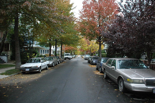
Albemarle Road, just east of Coney Island Avenue, April 2008
Albemarle Road, Prospect Park South

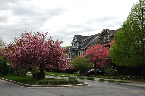
Tomorrow’s New York Times Real Estate section provides a brief history and profile of Albemarle Road in Prospect Park South, a block from my home:

Grandest of all the streets in Prospect Park South is Albemarle Road, a broad, esplanaded boulevard of stately neo-Classical, Queen Anne and Colonial style mansions. In fact, for the three blocks from Argyle to Buckingham Roads, Albemarle is one of the grandest residential streets in the whole city, even with some dings and dents.
Streetscapes | Albemarle Road: Brooklyn’s Stately Esplanade , Christopher Gray, New York Times, June 22, 2008

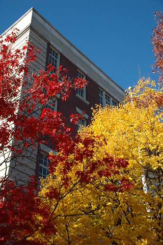
I’ll say. Prospect Park South is the most photogenic neighborhood I know in Brooklyn. I’ve got over 100 photos of Albemarle Road alone on my Flickr site.

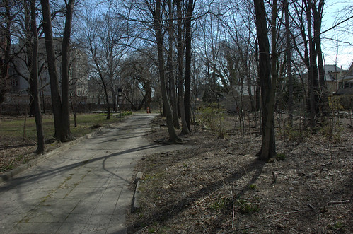
The greenscape is as impressive as the architecture:

Mr. Alvord created Albemarle Road as his main boulevard, with a planted strip down the middle and a dozen imposing houses east of Argyle Road, most built from 1899 to 1910. They created a most unusual place and were made grander by his main requirement — that no fences, hedges or plantings extend beyond the house lines, so the front yards combine into a unified majestic sweep.

Albemarle Road, looking west from Rugby Road, Prospect Park South, November 2007
Albemarle Road, looking east from Rugby Road, Prospect Park South

The Times fails to credit the man responsible for designing and planting these grand grounds, John Aitkin (or Aiken, I’ve seen both spellings):

Thousands of Shrubs, Plants and Trees to Be Set Out in Flatbush

Dean Alvord, owner, and John Aitkin, landscape gardener of Prospect Park South, the new residence park of Flatbush, have just returned from a tour of the nurseries [of several cities], where selections were made of over five thousand five hundred [5,500] ornamental shrubs, plants and trees for planting this fall. The list comprises rare evergreens and deciduous varieties chosen with reference to symmetry of form, color of foliage and beauty of flower. A foreign order has also been placed for 10,000 Holland bulbs of early spring blooming flowers, tulips, hyacinths, crocus and narcissus [Daffodils].

The form of street decoration carried out in Marlborough, Rugby and other north and south roads in Prospect Park South, will be varied in Albemarle road, where the unusual width will admit of a parkway through the center, with an asphalt driveway on either side. The more dwarf growing ornamentals will be planted in the parkway, and rows of shade trees will line the inside of the sidewalks.

Altogether, this fine residence section will contain the widest variety of hardy ornamentals and herbaceous plants to be found outside of city parks.

Suburban Ornamentation, The Brooklyn Daily Eagle, September 17, 1899, page 10 [Note: The same item, with slight variations, appeared with the title “Beautifying the Suburbs” on September 4.]

The Flatbush Malls sit within the area known as Victorian Flatbush, named because of the dominant architectural style. In the early 1900s, private developers constructed malls like this one to make the neighborhoods they built more attractive. Malls are common in New York’s outer boroughs. Dean Alvord bought 50 acres of farmland in 1898 to develop Albermarle and Kenmore Terraces. He hired the Scottish landscape architect John Aiken to create a rustic suburban neighborhood within the constraints of the Brooklyn street grid, and the result was largely achieved through the creation of these malls. Extending down the center of Albemarle Road, the Flatbush Malls run from Coney Island Avenue to Buckingham Road, then round the corner and continue one block north on Buckingham Road.

Aiken looked to Commonwealth Avenue in Boston, Massachusetts for inspiration. His mall on Albemarle Road is narrower than the malls on Commonwealth Avenue, as it does not include a central promenade like the one along the Boston street. The original landscaping of the malls featured shrubs and flowers, but did not include trees. The malls are now lined with a mixture of pine and oak trees, holly bushes, and other trees and shrubs, as well as seasonal flowers that grace the intersections. As part of the streets, the malls are owned by the New York Department of Transportation while Parks is charged with the planting design and maintenance.
Flatbush Malls, Historical Sign, Parks Department

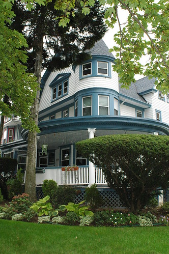
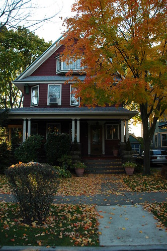
1305 Albemarle Road, Prospect Park South
1305 Albemarle Road

The Times article highlights a handful of individual homes, including 1305 Albemarle Road, the house I picked out as a good place for a haunting last Halloween:

The most unusual of these dwellings is the one built in 1905 for George E. Gale at 1305 Albemarle, at the northeast corner of Argyle Road, in white clapboard with a colossal two-story Ionic portico. Designed by an architect known only as H. B. Moore, the Gale house has a striking assortment of windows, among them roof dormers with a kind of webbed sash, topped by ebullient broken pediments. On the second floor, there are spider-web-type windows with Gothic-style sashes, and on the rear are leaded glass windows.

Related Content

Good Place for a Haunting #2, October 30, 2007
Fall Color along Albemarle Road in Prospect Park South, November 21, 2006
Conservatory Envy, September 10, 2006
Albemarle Road, Prospect Park South (Flickr photo collection)

Links

Streetscapes | Albemarle Road: Brooklyn’s Stately Esplanade , Christopher Gray, New York Times, June 22, 2008
Flatbush Malls, Historical Sign, Parks Department
Suburban Ornamentation, The Brooklyn Daily Eagle, September 17, 1899, page 10

A report on last night’s Flatbush Unity Garden kickoff meeting

Anne Pope reports on last night’s meeting regarding the community garden for Flatbush, now named the Flatbush Unity Garden:

A group of 20+ people met at P.S. 217 to share their ideas of what they’d like this community resource to become. In addition to growing vegetables and fruits and flowers, what many of us expressed was the desire for a place where we can meet our neighbors, form ties to our community, and enjoy a peaceful outdoor environment. New York City has many examples of gardens that serve as hubs of neighborhood cultural and social interaction as well as providing beautiful green spaces (and in some cases food as well). Clearly there is a longing for such a place here in Flatbush, and our goal is to create one.
Flatbush Unity Garden kicks off!, Sustainable Flatbush

I’ve added a new tag, Flatbush Unity Garden, for all my posts and photos of this project.

Related content

Blog posts
Photos

Links

Flatbush Unity Garden kicks off!, Sustainable Flatbush

Sunday, April 27: A day for trees in Flatbush

A reminder that you have two opportunities to get your green on in Victorian Flatbush this Arbor Day weekend on Sunday, April 27.

Ditmas Park West Arbor Day 2008Flyer for Sustainable Flatbush Street Tree Walking Tour

At 9:30am, meet at 458 Rugby Road to plant trees in Ditmas Park West and spruce up tree pits. Over 14 years, Ditmas Park West residents have planted 300 trees. Their long-running tree-planting program can serve as a model for other neighborhoods to green their streets.

Starting at 1pm, meet at 1414 Cortelyou Road to enjoy and learn about some of the trees in Victorian Flatbush. The Sustainable Flatbush Street Tree Walking Tour will loop through the neighborhoods of Beverley Square West and Prospect Park South. A Google Map of the tour route is available.

Related Posts

Plant Trees in Ditmas Park West
Sustainable Flatbush Street Tree Walking Tour

Links

Sustainable Flatbush
Trees New York

Sunday, April 27: Sustainable Flatbush Street Tree Walking Tour

Updated 2008.04.21: Added Google Map.


Westminster Road, Beverley Square West, looking north from Cortelyou Road

On Sunday, April 27, in celebration of Arbor Day weekend and Spring in bloom, join Sustainable Flatbush and others as we take a walking tour of one of our neighborhood’s greatest assets: our street trees.

Experience the neighborhood’s amazing wealth of street trees — including some that are more than 100 years old!

Throughout the tour, your street tree guide will:

  • Identify trees and their characteristics
  • Share interesting facts
  • Explore local tree history
  • Discuss the many ways street trees benefit the environment
  • Explain how to obtain and care for street trees

and much more!

Newly Planted Street Tree on Cortelyou Road

Credit: Keka Marzagao
Flyer for Sustainable Flatbush Street Tree Walking Tour

WHEN:
Sunday, April 27, 2008, Arbor Day Weekend, 1:00 PM – 4:00 PM

LOCATION:
Tours start and finish at 1414 Cortelyou Rd, the office of NY State Assembly Members James Brennan and Rhoda Jacobs. The tour will loop through the neighborhoods of Beverley Square West and the landmarked Prospect Park South Historic District.

DIRECTIONS:
Take the Q train to Cortelyou Rd. and walk one block west (left), toward Marlborough Rd., after exiting the station.

SPECIAL DETAILS:
The tour is just about a mile in length and will take place rain or shine.
Please dress appropriately for the weather and the walk.


View Larger Map

Tree identification with Trees NY at Greening Flatbush
Tree ID, Greening Flatbush

ABOUT SUSTAINABLE FLATBUSH: Sustainable Flatbush provides a neighborhood-based forum to discuss, promote and implement sustainability concepts in Brooklyn and beyond.

Hydrant and Tree, 297 Westminster Road, Beverley Square West

Related Posts

Factoids: Street Trees and Property Values, December 2, 2007
Factoids: NYC’s Street Trees and Stormwater Reduction, November 15, 2007
Basic Research: The State of the Forest in New York City, November 12, 2007

Links

Street-Tree Walking Tour next Sunday!, Sustainable Flatbush
Trees NY

amNY takes a look at Prospect Park South

170 Stratford Road, Prospect Park South
Tomorrow’s edition of amNY has an article on Prospect Park South, my neighborhood neighbor to the north, in their real estate (what else) section:

Deep in the belly of Flatbush lies an enclave of colossal freestanding houses, characterized by turrets, oriel windows, grand entrances flanked by columns and expansive wraparound porches.
City Living: Prospect Park South, amNY, January 3, 2008

I don’t know about “deep in the belly”; PPS lies rather to the northern end of Flatbush.

171 Marlborough Road, Prospect Park South

Unusually for a real estate piece, the article hints at some of the disparities and tensions with which Flatbush is challenged:

Though the neighborhood never fell into disrepair, relations between Prospect Park South and the less-wealthy surrounding areas have seen some rough times in the past.

In the 1970s, muggings and various thefts occurred along Church Avenue and Cortelyou Avenue, the main drags of the area. It had gotten bad enough that Prospect Park South’s residents began paying for private neighborhood security. According to residents, things have improved since then.

Still, some have their doubts about the relationship between Victorian Flatbush — a blanket term for Prospect Park South and the cluster of ritzy neighborhoods to the south [I don’t feel that “ritzy, but okay] — and other parts of Flatbush.

“To be honest, it’s separate,” said one resident, who did not want to be named. “There’s just not much interaction between the two; a silent hostility, perhaps.”

The article includes a brief interview with local realtor and long-time resident Mary Kay Gallagher.

145 (left) and 155 (right) Argyle Road, Prospect Park South
145&155 Argyle Road

Related Content

My Posts tagged Prospect Park South
My Flickr Collection of photos of Prospect Park South
My Flickr photos tagged Prospect Park South

Upcoming Local Events

Some quick notes of things happening within a couple blocks of me over the next few weeks. Details for all these events are available from the Google calendar in the sidebar.

This Weekend

Saturday December 8 and Sunday, December 9, 1-6pm, Prospect Park South resident Karen Friedland hosts an Art Show and Sale.

Sunday, December 9, 10am-3pm, P.S. 139 has their annual Holiday Craft Fair.

Next Week

Wednesday, December 12, starting at 6:30pm, Imagine Flatbush 2030 Workshop #2 at Brooklyn College.

Next Weekend, Sunday December 16

1:45-4pm, Beverley Square West Holiday Caroling. Meet at the Tot Lot at Cortelyou and Argyle Roads at 1:45pm.

3-5pm, Cortelyou Road Tree Lighting, at the Tot Lot.

3:30-5:30pm, The Regina Opera, at the Victorian Place Cultural Center / Temple Beth Emeth.

Forgotten Flatbush: The Albemarle Road Pedestrian Bridge

In the first Imagine Flatbush 2030 workshop, we enumerated “Assets” and “Challenges”. At our table – and it sounded like the experience was shared at others’ – where someone lived emerged as a primary determinant of what appeared in which category. Sometimes shared concerns, such as transportation, appeared as both an asset and a challenge, depending on where one lived. It became clear to me that the lines can be sharply drawn, sometimes block-by-block.

I’m a newcomer to the area, having moved here only in Spring of 2005. I researched more and more about the area and its history as we committed to buying a home and moving here. I’ve still only visited a small portion of Flatbush. IF2030 is making me curious about exploring more of it.

Part of what I want to explore more of is literally “on the other side of the tracks” from where I make my home. The B/Q subway line runs through this neighborhood as an open trench. There are several places where there is no crossing, and the cut forms a geographical barrier, a steel river, separating one side from the other. It wasn’t always so. With homage to Forgotten NY, here’s a little piece of Flatbush that’s not quite forgotten, still part of living memory, the Albemarle Road pedestrian bridge.

Google Map of the location of the old Albemarle Road pedestrian bridge. 143 Buckingham Road is also highlighted; it’s a landmark in all the historical photos of this crossing. The markers show where I took the photos for this article.

View Larger Map

The BMT as I remember — never rode it much, but had relatives on East 17th & Beverley Road. We would always go to the Albemarle Road footbridge by the tennis courts over the BMT cut, and watch the trains.
– Steve Hoskins, SubTalk Post #93389, NYC Subway

Eastern Dead End of Albemarle Road at Buckingham Road. 143 Buckingham Road is at the left of the photograph.
Dead End, Albemarle Road at Buckingham Road

Western foundation of Albemarle Road Pedestrian Bridge

“I seem to have a memory – or is it just a dream? – going back to my earliest childhood, associated with a place about a mile in a different direction from where I lived, towards Prospect Park: it is a stretch of about five blocks of Albemarle Road, going from the Brighton subway underpass to Coney Island Avenue. One got there from our side of the subway tracks by crossing over on a small footbridge. On the far end of the bridge, Albemarle Road suddenly widens, and in the middle of it there is a traffic island, covered with trees and extending a 11 the way to Coney Island Avenue; there are also trees on both sides of the street. My first encounters with this scene are in my memory entirely intermingled with my dreams of it, a recurring vision of overwhelming loveliness at the edge of things, beyond which something entirely new and different must lie.”
– Ronald Sanders, A Brooklyn Memoir, via Living in Victorian Flatbush

Western Dead End of Albemarle Road near East 17th Street. 143 Buckingham Road is at the right of the photograph, across the tracks.
Western Dead End, Albemarle Road, near East 17th Street

East Foundation of Albemarle Road Pedestrian Bridge. 143 Buckingham Road is in the center, across the tracks.
East Foundation of Albemarle Road Pedestrian Bridge

Albemarle Road is interrupted by the subway cut for the B/Q lines. In the late 19th Century, several rail lines were developed to take passengers from the City of Brooklyn, what we now think of as downtown Brooklyn, through the other villages and towns such as Flatbush, to the beach resorts on Coney Island and Brighton Beach. By the 1870s the Brooklyn Coney Island Railroad ran along Coney Island Avenue. By the 1890s, the Brooklyn, Flatbush and Coney Island Railroad (BF&CI) ran along what is now the current route of the B/Q subway line. Most of Flatbush was still farmland at the time. When the Flatbush farms were sold and the area was developed at the turn of the 20th Century, the tracks still ran at grade.

In this 1873 map of Flatbush, Prospect Park and the Parade Grounds are already laid out to the north, and the Brooklyn Coney Island Railroad runs along Coney Island Avenue. On this map, Parkside Avenue is named Franklin Avenue, Church Avenue is named Church Lane, and Cortelyou Road is named Turner Harrow (or Narrow?) Lane. The Waverly Avenue shown on this map no longer exists; it’s later replaced by Albemarle and Beverly Roads Road, whose future locations are shown, but neither named nor yet built. The future route of the B/Q line is not shown. The families whose landholdings and houses appear on this map lent their names to several streets and neighborhoods: Turner, Hinkley, Ditmas and Vanderveer.
Map of Flatbush, Brooklyn, 1873

In an 1888 USGS Survey Map of Brooklyn, just a small portion of which is shown here, Waverly Avenue has been “de-mapped.” The roads built in its place, unnamed on this map, are Avenues B and C; these will be renamed later to Beverly and Cortelyou Roads. Between them run East 11th through East 14th Streets; in the early 1900s, these will be renamed to Stratford, Westminster, Argyle and Rugby Roads to cash in on the cachet of Prospect Park South. The BF&CI, which began service in July 1878, is also now in place. East of that, the eastern half of Avenue A (Albemarle Road) has been built, along with East 17th through 19th Streets.
Detail, 1888 USGS Survey Map of Brooklyn

Through the early 1900s, all these railroad lines ran at grade, at street level. There were also trolley lines, at first horse-drawn, then later electrified, on many of the crossing streets. Development brought a burgeoning residential population, more traffic, and more traffic conflicts and accidents. The decision was made to separate the rail and street traffic by moving them to different levels, passing above and below each other.

This photo from the 1918 “Reports of the Brooklyn Grade Crossing Elimination Commission” shows the Albemarle Road Footbridge. The line has been widened to four tracks and now runs below grade. Today, the local Q train runs on the outer tracks, while the express B runs on the inner tracks. 143 Buckingham Road is visible on the upper left of the photograph. Thanks to Art Huneke for permission to use this photograph. This photo appears on his page Brighton Beach Line, Part 3.
Albemarle Road Footbridge

The physical contrasts could hardly be stronger across the tracks: a wide, tree-lined boulevard with large, detached wood-frame houses on one side, and tall, multiple-unit residential buildings with few trees on the other. It is tempting to imagine what it would be like to restore the pedestrian bridge, eliminating at least a geographical barrier between these two halves of the same neighborhood. Would it help us to make other connections, to recognize our common assets and challenges, and work together to create a future we can all live with?

Related posts

Imagine Flatbush 2030

Links

My Flickr photo set
Brighton Line, NYC Subway
ARRT’s Archives, Art Huneke’s Web site
Rapid Transit Net
The Brooklyn Grade Crossing Elimination Project, 1903-1918

The Luminous Streets

P.S. 139, Cortelyou and Rugby Roads, Beverley Square West, Flatbush, Brooklyn
P.S. 139, Beverley Square West, Brooklyn

This has been a spectacular year for fall foliage. We had ample, sometimes record, rainfall over the summer. We didn’t get a long drought at the end of the summer which often ruins the fall colors. And temperatures finally got cool at night, while warm during the day. We just had our first hard freeze this week.

Barbara Corcoran, avert your eyes. The rest of us can enjoy this gift. We’re just past peak this weekend, but there’s still plenty of great color. So get out and walk around.

Fothergilla, Vinca minor, and Maple leaves, 329 Westminster Road, Beverley Square West
329 Westminster Road

Japanese Maple, 1505 Albemarle Road, Prospect Park South

Field 11, Parade Grounds, Caton Avenue

Abandoned, East 16th Street

315 East 18th Street, Beverly Square East

346 East 18th Street, Beverly Square East
346 East 18th Street, Beverly Square East, Brooklyn

196 Marlborough Road, Prospect Park South

Beverly Road, Beverley Square West
Beverly Road, Beverley Square West, Flatbush, Brooklyn

Japanese Maple in front yard, 260 Westminster Road, Beverley Square West
Japanese Maple in front yard, 260 Westminster Road

I’ve been walking past, beneath, this every morning on my way to the Beverly Road subway station. Nothing like starting your commute in awe.

1422 Beverly Road, Beverley Square West
1422 Beverly Road

Tomorrow’s Flatbush Community Garden Meeting is Cancelled

The public meeting about the nascent Flatbush Community Garden (The “Ex-Lax” Gardens), tentatively scheduled for tomorrow morning, has been cancelled.

The owner of the property is not available to meet tomorrow morning.

There are tentative plans for a community meeting before the end of the year. When those plans are confirmed, I will publish them here.

The Future Home of the Ex-Lax Gardens

Updated 2007.11.03: Updated with more history from Erin’s comment. Added photos of the site I took last April.


Future Flatbush Community Garden

This map highlights the future location of a new community garden to be created in Flatbush, in the neighborhood of Prospect Park South. The red border outlines part of the property, which also includes the smaller wedge of land to the east, next to the B/Q subway line. The underlying image is aerial photography from 2004. The gray shapes are the outlines of buildings. The gray box within the red border is a garage, which you can see in the photos below.

The total area is .8 acres, huge by city standards. You can see from the photo that the property is covered by trees. The property is vacant, but not abandoned. It’s owned by a resident of the area who wants it to benefit the community, as a community garden.

Susan Siegel, outgoing Executive Director of Flatbush Development Corporation, has been in communication with the owner of the property for some time. I first heard about this project in February of this year from Jan Rosenberg of Friends of Cortelyou and Brooklyn Hearth Realty. I attended a meeting of some interested community members. Things have been quiet until this week, when Susan let us know that the owner has given us the go-ahead.

The site has an interesting history. As my neighbor, Erin Joslyn, notes, this was originally the home of Dean Alvord, the developer of Prospect Park South, later purchased by Israel Matz:

One of the most impressive homes in Prospect Park South, was the enormous mansion purchased in 1920 by Israel Matz, founder of the Ex-Lax company. After years of neglect, it was consumed by fire in 1958.
Forgotten Flatbush: When Flatbush was Greenwich, Victorian Flatbush, An Architectural history

The forest which lives on the site now is just 50 years old, grown since the building burned down in 1958. “Forgotten Flatbush” includes an old aerial photo of the area from 1908, a hundred years ago, which shows the old “Ex-Lax Mansion”, and the future location of the community garden. The trees for which the neighborhood is known are absent from the photo; they were just a few years old.

Here are some views of the site, taken last April.

Future Site of Flatbush Community Garden
This is the view south down the central drive into the site. The garage is on the right. There’s a lamp post on the left, with Daffodils blooming at its base. Not visible in this photo, the house foundation is to the right.

Future home of the Flatbush Community Garden
This is a view southwest, to the right of the central drive. The garage is to the left. The area in front of the garage and extending to the right is where the house stood.

Old foundation
The sunken area in this photo is part of the original foundation of the house.

Future Site of Flatbush Community Garden
This view is southeast. You can see the garage in this view, too. Somewhere between the garage and where I stood, behind the fence on the right, is the foundation of the house which stood there.

Most community gardens don’t start with a forest. This presents unique opportunities and challenges. The southern end of the property is already partially cleared and cultivated as gardens. For more residents to grow vegetables, more trees will need to be cleared.

I hope that the northern end, at least, can be kept forested. Many of the trees are likely “weed” trees, invasive species, which can and should be removed. There is already wildlife there, and this part of the property could be preserved as a wildlife and bird refuge and sanctuary. There could be wildflower walks and native plant gardens, cool ferny sanctuaries, shady refuges, and story circles.

The foundation of the old house is largely intact, now largely filled in by a half-century of leaf litter and plant growth. This could be cleared and restored. This could become an educational part of the site, evidence of its history. I have visions of developing it as a sunken garden, a grotto of native plants and ferns, which can fulfill other important educational purposes.

Now that the owner has given their go-ahead, there will be many community meetings and other events for those who want to participate and contribute. I’ll post these here on this blog and add them to the calendar in the sidebar.

Links

Backyard of the Day
Forgotten Flatbush
OASIS online mapping service
Ditmas Park Blog
[where: 1522 Albemarle Road, Brooklyn, NY 11226]