Resource: Animated Map of Historical Development

Trulia Hindsight is an animated map of homes in the United States from Trulia. The animations use the year the properties were built to show the growth of streets, neighborhoods and cities over time.

The title of this post links to a map covering most of Victorian Flatbush, as well as Kensington. On that map, the years range from 1800 to the present. I can only find one little blip for the year 1800; you can find it if you pause the animation, then drag the year slider one year at a time. Then the map shows nothing until 1895

Trulia uses publicly available data for the year of development. For NYC, these data are notoriously unreliable for specific properties; for example, it shows our house was built in the 1930s, although we know it was built in the early 1900s, most likely 1900. Nevertheless, the data are reasonably valid for showing trends.

I’ll try to get a good screenshot.

Via OuterB.

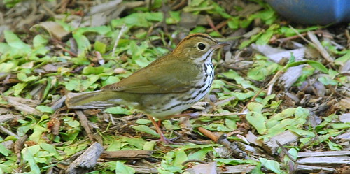
Ovenbird, Seiurus aurocapillus

At 4:30 this afternoon, I photographed another “life bird” for me, this time while I was sitting in the backyard garden: an Ovenbird, Seiurus aurocappilus.

Ovenbird, Seiurus aurocapillus

These are the best from about 35 shots I took in rapid succession. I tried to adjust the color for a truer representation, or at least consistency. I need some better software tools for that, I think. Exposure in the backyard ranges from full shade, to dappled leafy shade, to full sun. And my little visitor ranged through all of it. Most of the shots were ruined due to camera shake, ie: photographer shake. Others were blurred by the motion of the bird itself; in the shade, the shutter speed was too slow to freeze its motion.

In the mixed native plant border, that’s a cinnamon fern behind, and the stem of a Turk’s Cap Lily in front. You can see the orange patch on the crown, a key for this species.
Ovenbird, Seiurus aurocapillus

Here’s the original, full-frame shot showing more of the border. The blurry thing on the right is a wooden planter I’d just finished planting with a female Winterberry, Ilex verticillata.
Ovenbird, Seiurus aurocapillus

Rear view, also showing the orange patch on the crown.
Ovenbird, rear view

The ovenbird visited me for less than five minutes. It started out in our back neighbor’s cherry tree, where I couldn’t get a good shot and lost sight of it. I thought it flew off.

I was surprised to then see the bird on the ground, beneath one of our Adirondack chairs, about six feet from me. It wandered around the backyard. You can see much of the in-progress gardening clutter around the bird: a bin holding compost, a bag of leaves, and so on. It didn’t seem to be probing the ground. Maybe it was just checking out the neighborhood.

I take this as a good sign. My plan for the backyard is to recreate a woodland opening. I’ve been building up a collection of native shrubs, wildflowers and ferns. The past two weekends I’ve been reorganizing the space, clearing beds, and planting things which have been sitting in containers all this time. I’m starting to recreate the layered foliage structure of a clearing in an Eastern woodland. I feel like the ovenbird showed up as if to say: Getting warmer.

Event, June 10: 2007 Victorian Flatbush House Tour

Update 2007.06.11: See my photos from the tour.


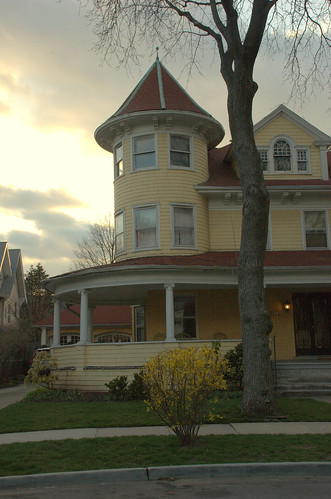
210 Rugby Road, Prospect Park South Historic District, Victorian Flatbush, Brooklyn, New York
210 Rugby Road

I just learned from Living in Victorian Flatbush, the blog of real estate broker Mary Kay Gallagher and company, that you can now buy tickets for the Flatbush Development Corporation‘s 2007 Victorian Flatbush House Tour.

The house featured in the photograph on FDC’s House Tour page is 210 Rugby Road.
I hope this means it’s on the tour this year. This is in the Prospect Park South Historic District, and it’s one of my favorites. At the top of this post is one of my photographs of this house. It’s a perfect Queen Anne Victorian, with a turret and wrap-around porch. It’s also visible from Beverly Road, so I pass it nearly twice every weekday going to and from the subway.

One change this year is that the tour starts out at Temple Beth Emeth at the corner of Church Avenue and Marlborough Road. This is on the north edge of the Prospect Park South Historic District. The past two years, the starting point has been the Flatbush-Tompkins Congregational Church in the Ditmas Park Historic District.

I’m disappointed in two more changes for this year’s tour:

  1. There are only 12 houses on the tour this year. This is fewer than last year, which was fewer still than the year before. I don’t know if this is a trend, or what this signifies for the long-term viability of the tours.
  2. The past two years have been House & Garden Tours. This year, apparently, no gardens are on the tour. Surely there are gardeners willing to open their spaces to visitors. Maybe the audiences for garden and house tours are simply too incompatible.

Corrected subway directions: As of 5/16, the subway directions on FDC’s Web site are still incorrect. I contacted them by email and they’re in the process of updating their materials.

Take the Q train to CHURCH AVENUE, not Beverley Road (or Beverly, both spellings are used). Exit at the Church Avenue (south) end of the station. The start of the tour, Temple Beth Emeth, is on Church Avenue at the corner of Marlborough Road, just three streets West of the station. (Marlborough Road is the same as East 15th Street.)

You can walk 2-1/2 blocks North to Church Avenue from Beverley Road to get there. It’s just a longer walk. On the other hand, it’s also a prettier walk, since you walk through the Prospect Park Historic District. Take your pick!

Another reason to loathe real estate brokers …

Trying to locate their recent report on sales figures, I idly browsed the Corcoran (“Live Who You Are”! Be All That You Can Be!) Web site for my neighborhood. I don’t expect to find Beverley Square West. I would hope to find Victorian Flatbush. They’d don’t even list Flatbush. I found what I expected:

Ditmas Park: Runs from Parkside Avenue to the north, Ditmas Avenue to the south, Ocean Avenue to the east and Coney Island Avenue to the west.
Corcoran Neighborhood Guide to Ditmas Park

Lest one quibble “Oh, it’s just a real estate name,” they continue in the second paragraph:

… This landmarked district …

WRONG! The landmarked Ditmas Park Historic District lies only within the boundaries of Dorchester and Newkirk Avenues, and Ocean Avenue and the B/Q line. The only other landmarked area within the boundaries they describe is Prospect Park South. The rest of their “Ditmas Park” is not landmarked.

It’s worse than that. They have no idea where they are.

Their descriptions conflate several neighborhoods – some landmarked, most not – and get basic information wrong. They provide the wrong school number for P.S. 139. There’s this:

These homes were originally built for the likes of the Guggenheims and films stars like Mary Pickford and Douglas Fairbanks.

Again, not in Ditmas Park. The Guggenheim Honeymoon Cottage is in Beverley Square West, my neighborhood. The Pickford/Fairbanks House is in Ditmas Park West.

And there’s this:

Many have porches and garages and sit on wide tree-lined streets with English sounding names like Argyle and Rugby.

Only the streets between Coney Island Avenue and the B/Q lines – half the area they claim to describe – carry these names, borrowed from the status of Prospect Park South. Four different neighborhoods span those streets from Parkside to Ditmas, and none of them are Ditmas Park.

The boundaries they give describe only part of greater Victorian Flatbush; they omit half the neighborhoods. Extending the southern boundary from Ditmas Avenue to Avenue H, between Coney Island Avenue Ocean Avenue lie West Midwood, Midwood Park, and Fiske Terrace. The latter two are proposed Historic Districts and are on track to become landmarked. Extending the eastern boundary to Flatbush Avenue, the Albemarle-Kenmore Terraces Historic District lies east of Prospect Park South, between Ocean and Flatbush Avenues, and South Midwood lies between Ocean and Bedford Avenues, and Foster Avenue south to Brooklyn College.

I’ve never had any dealings with Corcoran. We tried working with them when we were shopping for our home three years ago. They had yet to “discover” this area, and so had nothing to show us. Their reach had only extended to Windsor Terrace at that point, and we went to one open house there.

And, don’t bother trying to find a house a house on their Web site. You won’t find any. They only have “townhouses” …

Changes on Cortelyou Road

Cortelyou Streetscape – Looking East from Argyle Road. Credit: FDC
Dry-laid cobblestones, Cortelyou Road, South side, West of Stratford Road

Construction to revamp the streetscape on Cortelyou Road is well underway. I’m really interested to see how the new, wider tree pits and extra planting areas work out. With adoption by business and residents, they could be beautiful.

The plan calls for the planting of 40 new Linden trees, Flatbush Light Poles, benches, clocks, bike racks and wrought iron tree guards. This streetscape will create a public space that invites pedestrianism, improves public health, stimulates local economic activity, and attracts residents and visitors to the community.
Cortelyou Road, FDC

Today, the block was hopping, with activity from Coney Island Avenue to Rugby Road. Here’s the front of the library, at the northeast corner of Argyle Road:

Library Plaza, Cortelyou Road and Argyle Road, Northeast corner

Click the image above for larger sizes where you can see the scoring line along the sidewalk on the right-hand side.

Here are some other images from this afternoon.

Scoring the sidewalk, Cortelyou Road, North side, in front of library between Argyle and Rugby Roads

Curb and sidewalk reconstruction in progress, Cortelyou Road, South side, looking East from Stratford Road

Street Tree “”Barrier””, Cortelyou Road, South side, Stratford-Westminster Roads
Street Tree “"Barrier”", Cortelyou Road, South side, Stratford-Westminster Roads

Dry-laid cobblestones, Cortelyou Road, South side, West of Stratford Road

Cobblestone sidewalk margin, Cortelyou Road, South side, West of Rugby Road

Links

News: Four Borough Neighborhood Preservation Alliance Recommending Brooklyn Neighborhoods

The Four Borough Neighborhood Preservation Alliance (FBNPA), working with local advocates, has come up with a list of 18 buildings and nine potential historic districts in the borough that it would like to see designated by the city’s Landmarks Preservation Commission (LPC). …

Among the Brooklyn neighborhoods that FBNPA is recommending for landmark status are Canarsie’s Seaview Village, two Victorian Flatbush enclaves (Ditmas Park West and West Midwood), Prospect Heights, and streets in Williamsburg and Downtown Brooklyn.

Group touts new ‘landmarks wish list’, March 22, Courier-Life Publications

Ditmas Park West is immediately south of my neighborhood, Beverley Square West, and west (surprise!) of the Ditmas Park Historic District. West Midwood is south of Ditmas Park West and west of Midwood Park and Fiske Terrace, which have already been proposed, but not yet approved, as new Historic Districts.

They are also recommending the expansion of the tiny Carroll Gardens landmark area.

Among the structures on the list are several in Canarsie, Gravesend and Williamsburg, as well as one in Bay Ridge, one in East Flatbush, and one in Bushwick.

I’ve never heard of the Four Borough Neighborhood Preservation Alliance (FBNPA) before reading this article. I can’t find a Web site or any other contact information for them online. I would provide a link if I had one. If you know of anything, please leave a comment.

Landscape and Politics in Brooklyn’s City Council District 40

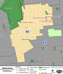
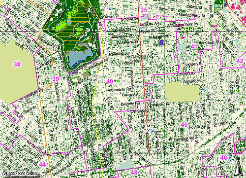
Brooklyn City Council District 40Next week, on Tuesday, February 20, there will be a special election to replace Yvette Clarke as Brooklyn’s 40th District City Council Member. Clarke was elected to Congress in last year’s elections. The council member elected on February 20 will serve only until the end of 2007. A general election in November will elect the member to serve the remainder of Clarke’s unfinished term.

Last week I attended a Candidates’ Forum on Preservation and Development. The Historic Districts Council, a sponsor of the Forum, has issued a Preservation Voter Guide.

There are several landmarked historic districts within District 40, and hopefully another soon. Still, most of the Victorian Flatbush neighborhoods are at risk of being lost forever due to inappropriate zoning and development.

NYC asks us to imagine What kind of city we want to live in by 2030. What happens to this area in the next decade will determine not only what happens by 2030, but this century and beyond. The neighborhoods of Victorian Flatbush are not only worth preserving, it’s critical to the future of this area that we do so. It’s not just about pretty houses, or property values. It’s about open space and shade. It’s about the rates of asthma and respiratory disorders. It’s about moderating surface temperatures by preserving and managing the urban forest, reducing heating and cooling demands. It’s about how many people will die in the heat waves we will experience by the end of the century. It’s about the quality of life for the entire area, and whether or not it will be livable in the future.


This map shows the locations of schools and parks in City Council District 40. Schools are indicated with blue dots. The green labels identify the location of parks. Open space, including cemeteries, ball fields, and so on, are outlined in green. Prospect Park abuts District 40 on the northwest. The Parade Ground south of that is ballfields. Other than that, there is a near complete absence of parks within District 40.

Brooklyn City Council District 40: Schools and Parks

This map shows landcover classification in District 40. Dark green areas are trees and forest. Light green areas are grassland, fields and such. Everything else is classified “impervious”, ie: buildings, streets, sidewalks, pavement, etc.

Brooklyn City Council District 40: Classified Landcover

South of Prospect Park, note the interrupted band of dark green that extends to the south boundary of the District. These trees provide the only greenery and shelter in District 40. This area is the lungs of Flatbush.

Now we zoom in on my little neck of the woods, the Victorian Flatbush neighborhood of Beverly Square West. This map shows the outlines of buildings and the landcover classification. At this scale, it becomes clear that it is the trees on private property, not street trees, and certainly not parks or “open areas”, that provide most of the tree cover.

Beverly Square West: Buildings and Classified Landcover

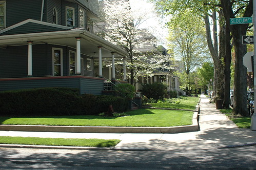
And this is what it looks like from the ground. These two photos show the view from the same street corner on my block, as it looks in Spring and Fall.

DSC_0498
Stratford Road, East side, looking South from the corner of Slocum Place

With no parks for blocks around, and few playgrounds, it’s no wonder that parents come to our streets to stroll their babies and walk their children. It’s the only green space within walking distance for many people.

Links:

Recent Neighborhood News

Still cleaning up my blogger clutter. Some recent news and other items about the area where we live.

Matthews Park

Our house was built in Matthews Park. Don’t look for it on any current maps of Brooklyn. Beverly Square West, the neighborhood where we live, was originally known as Matthews Park from at least 1900, the same year our house was built, to 1902. Two articles from the Brooklyn Eagle document the boundaries of Matthews Park, which exactly coincide with those of what is today called Beverly Square West.

A March 30, 1900 article, Attempt to Rob Bolles’ Home, is a report on burglaries in the area:

Mr. Bolles is one of a committee of three of the Matthews Park Association, appointed to visit the Police Board to find out why there are so few policeman in that section. Matthews Park extends from Beverley road to Avenue C, and from Coney Island avenue to Fifteenth street.

A March 5, 1902 article, Sign Posts for Matthews Park, describes the submission of “a design for cast iron sign posts to be placed on all corners of Beverley and Cortelyou Roads, from East Eleventh to East Fifteenth Streets, inclusive.” The same article also mentions that “it is intended to adopt on these blocks the same names at present in vogue for the same streets in Prospect Park South,” which is today a landmarked Historic District just up the block from us. So the numbered streets – East 11th through 15th Streets – became named Streets: Stratford, Westminster, Argyle, Rugby and Marlborough. Tony sounding, eh? Or, if you prefer, the acronym SWARM.

Links

Other Gardens: South Midwood Garden Tour, Sunday, July 30, 2006

[2006.08.03-11:40am EDT: See bottom of entry for link to article describing history of the Avenue H Station House.]

This post is rather lengthy. I’m hoping to make up for my numerous small and seemingly scattered, though all intricately interwoven in my mind, posts.

Google Map image of South Midwood area of Victorian Flatbush in Brooklyn. North is to the left in this image. The neighborhood is bounded by Foster Avenue (diagonal road) on the north (left), Brooklyn College (large ballfield) on the south (right), East 21st Street on the west, and Bedford Avenue on the east. South Midwood is one of about a dozen distinct neighborhoods of Victorian Flatbush.

On Sunday, July 30, I attended the South Midwood Garden Tour. I was invited by a fellow gardener from that neighborhood whose husband I had met at a “new neighbors” event last year, after we bought our house. We invited them to our house opening party last fall, and I got to sketch out the “garden in my mind” which was forming out of the weeds and dust which came with the house.

Avenue H Subway Station

The Avenue H Subway Station, just a few blocks from the start of the tour at the community garden. This station was recently granted landmark status. At the turn of the last century, it was a real estate office for the new developments arising along the old Coney Island RR line, now the B/Q lines. It’s the only wood-frame station house in the subway system, and the only one which was not originally built for a railroad purpose.

My journey began by taking the Q train from my local station a couple of stops south to Avenue H. The tour began at 11am at a community garden, the Campus Road Garden at Brooklyn College. This is located at the western end of the Brooklyn College campus, near the ball fields.

The light towers surrounding the playing fields have large nests of Monk Parakeets. Their calls were constant. Dragonflies were swarming over and around the gardens. Butterflies were everywhere.

DSC_0951

DSC_0940

Campus Road Garden, looking north.

DSC_0942

Campus Road Garden, looking west back toward Avenue H.

DSC_0947

DSC_0961

DSC_0962

The house of the first garden on the tour. The garden in the backyard was lovely, but I really liked the look of these vines embracing the turret.

DSC_0965

The backyard garden of the same house. The gardener was not available for interrogation, but the tour guide told us that everything had been designed and built over several years by the owner.

DSC_0974

Second garden on the tour. The cool shade and sound of the waterfall was a welcome relief from the oppressive heat that day. The owner is standing with her back to the camera. This garden was just built in June of this year.

The next four photos are all from the same house and gardens. It’s on a double lot, 100ft x 100ft, a rarity in Brooklyn, but South Midwood has several of them. This garden was one of the highlights of the tour for me.
DSC_0978
DSC_0981
DSC_0982
DSC_0983

Skipping ahead a few gardens, these next two photos are different views of a well-designed and inviting accessible garden. The raised beds were customed designed and built for the gardener, whose mobility had become restricted over time. The integral seating is a terrific feature, providing both a place to sit and work the beds, and inviting visitors to get up close and personal with the plantings. This was another garden at the top of my list of favorites. I have so many ideas for my own gardens from this one.
DSC_0993
DSC_0995

Another backyard garden.
DSC_0997

At this stop it was the house, and not the gardens, which was featured on the tour. But the gardens make their own statement, which I would not want you to do without.
DSC_0999

A couple of flower portraits from two other gardens.
DSC_1008
DSC_1012

I have a special fondness for large, red Hibiscus. It takes me back to my childhood in space-age Florida. I picked flowers just like this from the monstrous, garage-sized shrubs outside our house to dissect, study, and learn all the parts of the flower. I even put together a presentation on flowers and pollination for my grade school classmates and school. Yes, I was a curious child, in all the meanings of the word.

At the penultimate stop, the gardener invites his guests to enjoy the sensual pleasures of his herb garden.
DSC_1016

The last, but not least, stop on the tour, home of the tour guide. The food and refreshments were raved over. And the gardens were nothing to sneeze at, either.
DSC_1020

Links: