I am astonished to find that tomorrow’s New York Times City Section has an article on Victorian Flatbush, not “Ditmas Park,” which they finally realize only applies to one historic district in this large area. And in this article, they focus on the “forgotten” neighborhoods, those which don’t have landmark protection, and which are in danger of being eroded and lost forever to “development”:
The neighborhoods of Victorian Flatbush are of particular interest to historians because in many respects they were the first suburbs. With the newly built Brooklyn Rapid Transit rail line stretching out to Coney Island, the farmland of the Dutch village of Flatbush became a prime location in the early 20th century for what was considered commuter living.
– Peaked Roofs, Crossed Fingers
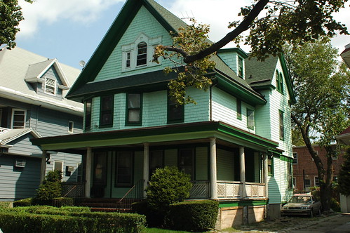
315 East 18th Street, Beverly Square East
All the neighborhoods featured houses built in the most fashionable of Victorian-era styles, among them Tudor, Queen Anne, Colonial Revival and Georgian. These houses, adorned with carved moldings, fluted columns, copper trimmings and wide, open porches, evoked a lifestyle that went beyond architecture. Exclusive social clubs flourished in the area, as did community associations, many of which have been the driving force in campaigns for historic protection.
457 Rugby Road, Ditmas Park West
“We don’t want the Manhattanization of Brooklyn,” said Ron Schweiger, the Brooklyn borough historian and a longtime resident of Beverley Square West. “We don’t want high-rises coming into residential areas. That’s why we want all of Victorian Flatbush to get historic district status.”
And though the neighborhoods of Victorian Flatbush have distinct characters, nearly all of them have one thing in common: residents eager to protect what is a remarkable and in some cases irreplaceable architectural history.
Beverley Square West
341 Rugby Road, Beverley Square West
209 (Left) & 215 (Right) Stratford Road, Beverley Square West
There’s a little bit of hand-waving around my neighborhood of Beverley Square West, resulting in several inaccuracies.
Beverley Square East and West, nestled between Prospect Park South and Ditmas Park [and Ditmas Park West] and completed just after the turn of the 20th century, were Ackerson’s major projects. The developer also got certain streets that run through Beverley Square West rechristened with upper-crust British names: East 12th, 13th, 14th and 15th Streets became Westminster, Argyle, Rugby and Marlborough Roads.
Somehow the Times lost one-fifth of Beverley Square West, omitting Stratford Road (East 11th Street) from their description of the neighborhood. Stratford Road is both the westernmost block and the one most at risk from inappropriate zoning in Beverley Square West and Ditmas Park West.
The street names originated in the development of Prospect Park South by Dean Alvord. Ackerson’s early advertising for developments here still used the numbered designations of East 11th, 12th, and so forth, not the names. By 1902, the named designations were extended south to what would become Beverley Square West and Ditmas Park West. Our bill from Con Ed, which was around before this building boom of the early 1900s, still uses the numbered designation for our street address.
All the original homes of the Beverley Squares were individually designed. Ackerson himself lived in a house in Beverley Square West, and the developer Pounds, a future borough president, lived in Beverley Square East.
From what I’ve learned of the history of the development here, this is not accurate. The houses on Stratford and Westminster Roads are stylistically different from those on Argyle, Rugby and Marlborough. Although no two houses are exactly alike on Stratford and Westminster, neither do they feature much of the architectural details – turrets, round oeil de boeuf (ox-eye) windows, unusual dormers, and so on – visible on nearly every house on the other blocks.
I think the houses on these two westernmost blocks were built largely using Victorian pattern books widely available at the time; they were mostly “builders’ specials,” not designed by architects. They were built earlier, and not by Ackerson. Early Ackerson promotional photos show houses already standing on Stratford and Westminster while Argyle and Rugby are nothing more than empty lots.
The earliest neighborhood name I’ve found for these five blocks is Matthews Park. Matthews Court is one of the short side streets joining Stratford Road and Coney Island Avenue. Not that long ago, “Beverley Square West” referred only to the Ackerson-developed blocks of Argyle, Rugby and Marlborough Roads. Stratford and Westminster had their own neighborhood association, called Westford Park. These two neighborhood associations joined forces to form the current, five-block Beverley Square West Association.
Related Posts
Victorian Flatbush at risk from inappropriate zoning, October 23, 2007
Landscape and Politics in Brooklyn’s City Council District 40, February 14, 2007
Matthews Park, September 29, 2006
Links
NoProPaSo, Kneel Before Your Creator, Crazy Stable
Victorian Flatbush: An Architectural History (Warning: contains intrusive popups)


